
Cymraeg / English
|

|
Historic Landscape Characterisation
The Tanat Valley
The following description, taken from the Historic Landscapes Register, identifies the essential historic landscape themes in the historic character area.
|
Character areas defined in the Tanat Valley Historic Landscape
|
The River Tanat and its dendritic tributaries dominate this narrow valley landscape running east to west in north Powys. The Tanat separates the Berwyn Mountains, to the north, from the rolling Montgomery Hills, to the south. It occupies a valley less than 1km wide whose floor is nowhere more than 150m above OD and with both sides rising steeply to about 300m above OD.
Cwm Rhiwarth and Cwm Pennant, the source of the River Tanat, are two deeply glaciated valleys cut into the south eastern slopes of the Berwyn Mountains. From their confluence at Llangynog, the River Tanat flows east through a broader valley surrounded by low hills. The Berwyn Mountains, which rise to 827m above OD at the summit of Cader Berwyn, present a formidable barrier to communications to the west, and as a result, the area has closer links with the borderlands to the east. The influence of man in this area has been present from prehistoric times and has not been confined to the valley floor. Consequently, the area presents a landscape of great diversity with evidence of landuse and settlement patterns from several periods and of varied nature.
The earliest evidence for occupation in the valley consists of a series of Bronze Age monuments now only visible from the air as crop-marks. The individual sites are often small and discrete, but together they comprise one of the best surviving groups of this type of archaeological evidence in Wales. They include a probable henge and pit circles at Meusydd and ring ditches, and ploughed out burial mounds, at Banhadla. More tangible remains survive from the later prehistoric period in the form of two large and impressive Iron Age hillforts at Llwyn Bryn-dinas and Craig Rhiwarth, each dominating the visual prospects of their respective halves of the valley. Excavations at the former have revealed evidence for early metalworking and might suggest that the size and location of the fort is the result of the importance of local ore which was more fully worked during the 19th century. The remains of prehistoric workings can also be seen at the upper end of Cwm Orog, north of Craig Rhiwarth hillfort.
The principal historic settlements of the area, Llanrhaeadr-ym-Mochnant and Pennant Melangell, are both the result of medieval religious foundations. Pennant Melangell, located in a secluded and tranquil valley, is associated with the 8th century legend of St Melangell. The existing church, which in parts can be dated to the 12th century, was supposed to have replaced a nunnery founded by Melangell, and contains the remains of a shrine which may once have held the saint's remains. Llanrhaeadr was an important ecclesiastical site and a clas foundation (a unit of administration based on monastic settlement) dedicated to St Dogfan. It is one of the 'Welsh churches, with the villages and churchyards' burned by the English in 1165, as recorded by Giraldus Cambrensis, and was the incumbency of William Morgan when he completed his Welsh translation of the Bible in 1587. Earlier medieval, secular settlement in the valley is evidence by the mottes at Cefn-côch, Cefn Glaniwrch and Maerdy.
While the landscape of much of the valley is the result of medieval and post-medieval agriculture, the upper reaches of the valley around Llangynog bear the marks of an industrial past. The mining of lead, phosphate and slate, together with granite quarrying had a significant effect on the landscape and economy of the area. The early origins of mining around Llangynog have already been mentioned, and it is possible that similar workings existed during the Roman period. However, it is not until the 16th century that the main period of exploitation began and continued until relatively recent times. Today, the remains of the mine workings are still evident, consisting of ruined buildings, levels, tramways, inclines, filter beds and spoil tips, much of which is readily identifiable. The mines and quarries were served by the Tanat Light Railway which was in operation from 1904 until 1960. The track has been removed, but much of the line and the ruins of the stations are still discernible.
 The Natural Landscape The Natural Landscape
The Administrative Landscape
Settlement Landscapes
Agricultural Landscapes
Transport and Communications
Industrial Landscapes
Defended Landscapes
Funerary, Ecclesiastical and Legendary
Landscapes
Ornamental and Picturesque Landscapes
Character areas
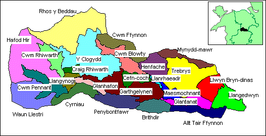
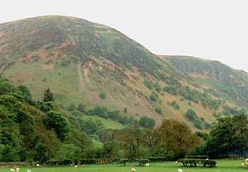
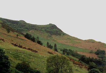
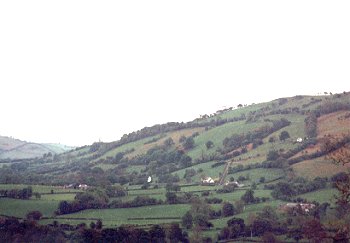
1000 Llwyn Bryn-dinas character area. Steeply sloping hill land with rocky outcrops, prehistoric hillfort, and late 18th- to early 19th-century encroachment of commons, and areas of ancient semi-natural woodland and modern plantations. Seen here is Llwyn Bryn-dinas viewed from the west, with the B4396 in the foreground, the former turnpike road between Knockin to Llanrhaeadr, improved in 1756. The field boundaries are mostly single-species hedges, now generally overgrown, representing 19th-century enclosure of common land. The ramparts of the prehistoric hillfort, established in the later Bronze Age, are visible on the skyline. Photo: CPAT 803.01 (back to map)
Click here for further information about this Historic Landscape Character area
Click here for character area map
|
|
|
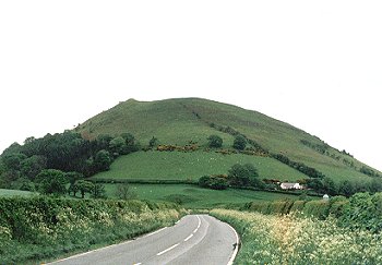
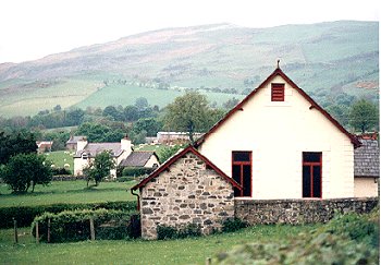
1001 Llangedwyn character area. Hilly, wooded and ornamental landscape, with large houses and gardens and estate farms with rolling pasture. Shown here is Plas-uchaf, the imposing early 18th-century brick house with sandstone dressings on the lower slopes of Llwyn Bryn-dinas, set in parkland with recent coniferous plantation beyond, viewed from the south-east. The probable late prehistoric enclosure at Plas-uchaf lies on the small hillock on the lower right foreground. The rampart of the prehistoric hillfort on Llwyn Bryn-dinas is visible on the skyline to the right. Photo: CPAT 803.00A (back to map)
Click here for further information about this Historic Landscape Character area
Click here for character area map
|
|
|
|
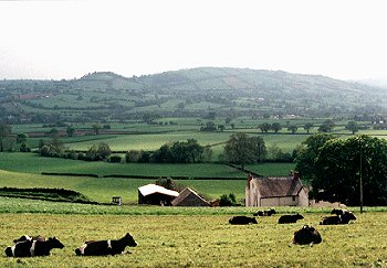
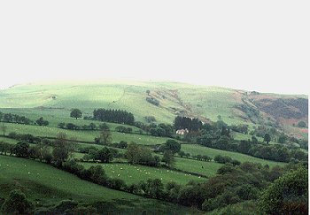
1002 Maesmochnant character area. Large rectangular fields with hedge boundaries on flat terrace slightly raised above the valley bottom, with complex of cropmark prehistoric and funerary monuments and standing stone. The large, flat rectilinear fields characteristic of the character area are visible in the middle distance, viewed from the north-east, which probably represent the enclosure of the open fields belonging to the medieval market town of Llanrhaeadr-ym-mochnant. In the foreground is Glaniwrch farm, in the Trebrys character area. On the horizon is part of the Brithdir character area. Photo: CPAT 805.12 (back to map)
Click here for further information about this Historic Landscape Character area
Click here for character area map
|
|
|
|
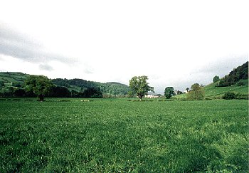
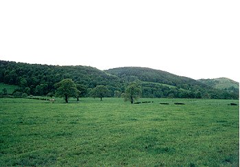
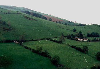
1003 Glantanat character area. Large rectangular fields with hedged boundaries on valley bottom in eastern area of Dyffryn Tanat. Seen here are the large, flat, low-lying fields, looking westwards towards Tan Llwyn farm. The valley floor at this point is only about 600m across, most of the fields, with low-cut hawthorn hedges, representing 18th- to early 19th-century enclosure of former common meadow. Photo: CPAT 803.04 (back to map)
Click here for further information about this Historic Landscape Character area
Click here for character area map
|
|
|
|
1004 Trebrys character area. Landscape of scattered larger farms of late medieval and early post-medieval origin generally set within their own medium- to large-sized semi-irregular fields. The view here is looking north-east towards Lloran-uchaf, one of the substantial farms dispersed farms of late medieval origin in this character area, characteristically with small to medium-sized irregularly shaped fields. New areas were being cleared and enclosed to meet the demand for land during the Tudor period, leading to the creation of a number of substantial farms. In 1560, Maurice ap Meredith of Lloran-uchaf was able to divide his small estate amongst his eight surviving sons. Photo: CPAT 803.18 (back to map)
Click here for further information about this Historic Landscape Character area
Click here for character area map
|
|
|
|
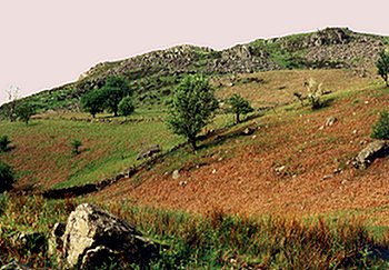
1005 Craig Rhiwarth character area, viewed from the south-east. Prominent craggy mountain with prehistoric hillfort, dominating Llangynog. The prehistoric hillfort lies on the summit of the distinctive hill overlooking Llangynog near the head of the Tanat valley. The hill is defended by natural cliffs and crags on all sides except the north, which is defended by a single stone rampart. The hillfort is undated, but is likely to have been first built in the later Bronze Age or early Iron Age, possibly in order to defend the lead and copper ores which occur at various points on the hill, that were worked from at least the late Tudor period up until the early 20th-century. Photo: CPAT 806.17A (back to map)
Click here for further information about this Historic Landscape Character area
Click here for character area map
|
|
|
|
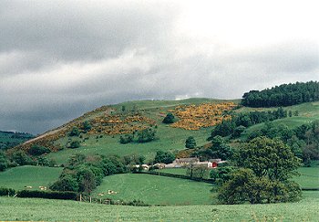
1006 Garthgelynen character area. Closely-spaced, small and medium-sized farms and fields, representing piecemeal expansion and enclosure of lower hill-slopes between the early 16th and 18th centuries. Viewed here are Cileos and Mochnant farms, seen from the south-west, with part of the Y Clogydd character area beyond. The clustering of medium-sized farms set in their own often irregularly-shaped and medium-sized fields is characteristic of the character area. A number of the farms in the character area have late medieval origins, with late 15th- to early 16th-century cruck-built farmhouses. Photo: CPAT 806.00A (back to map)
Click here for further information about this Historic Landscape Character area
Click here for character area map
|
|
|
|
1007 Cefn-côch character area, a 19th-century cottage landscape on the edge of the more marginal land at the boundary between the ecclesiastical parishes of Pennant Melangell and Llanrhaeadr-ym-mochnant. In the foreground is the Elim Calvinist Methodist chapel built in 1839, viewed from the south-east. Each of the cottages had its own small fields, gardens and paddocks enclosed often without permission from the common grazing. In the background is part of the Y Clogydd character area, a large area of common upland grazing enclosed during the later 19th century. Photo: CPAT 804.19A (back to map)
Click here for further information about this Historic Landscape Character area
Click here for character area map
|
|
|
|
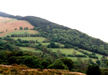
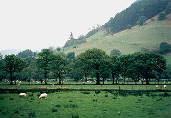
1008 Allt Tair Ffynnon character area. Diverse, steeply-sloping area with north-facing slopes on south side of Dyffryn Tanat, part wooded and part 19th-century enclosure of upland common. Seen here are Coed Garth-eryr and Coed Glan-Tanat, the wooded hills on the north-facing southern slopes of the Tanat valley opposite Llangedwyn, with the flat valley-bottom land in the foreground. The woodland is partly semi-natural oak woodland and part conifer plantation. The hill called Allt Tair Ffynnon, at the extreme right, is unwooded except around its lower slopes. Photo: CPAT 803.2 (back to map)
Click here for further information about this Historic Landscape Character area
Click here for character area map
|
|
|
|
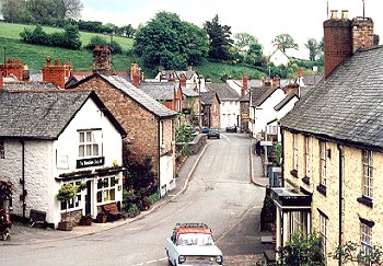
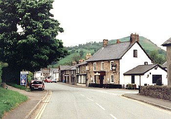
1009 Llanrhaeadr-ym-mochnant character area. Small former market town around early medieval clas church, with 18th- and 19th-century stone houses, inns, shops, chapels, and former mills, huddled in narrow valley of the Afon Rhaeadr. An early settlement probably grew up around the early medieval clas church on the east bank of the Afon Rhaeadr. The settlement, granted a market charter in 1284, continues to be of local importance as a commercial centre to the present day. As a consequence of the division of the kingdom of Powys in the late 12th century, the houses in the background, on the east side of the river, fell within Denbighshire, whilst those in the foreground fell within Montgomeryshire, until local government reorgnisation in 1996. Photo: CPAT 804.22A (back to map)
Click here for further information about this Historic Landscape Character area
Click here for character area map
|
|
|
|
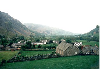
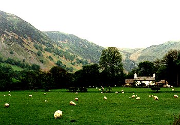
1010 Llangynog character area. Mining village with workers' cottages, inns, shops and chapels, viewed from the west, overshadowed by Craig Rhiwarth to the left. At its core is St Cynog's medieval church, but the origins of the present village lie in the early 18th-century when lead ore was discovered. It suffered from poor communications early on, though this improved when the turnpike road to Bala was built in the late 18th century, followed by the railway in the early 20th century. Photo: CPAT 804.12A (back to map)
Click here for further information about this Historic Landscape Character area
Click here for character area map
|
|
|
|
1011 Cwm Pennant character area. Remote and isolated, deeply glaciated valley with clustered small farms with small enclosed fields on lower slopes and valley bottom, medieval church and legendary associations with St Melangell, abandoned farms. The river Tanat begins at the waterfall at the top of the deeply glaciated valley. The valley is associated with the 8th-century legend of St Melangell whose church near the head of the valley became an important medieval cult centre. The valley formed the upper part of the large and complex parish of Pennant Melangell. The parish was split up due to population shift in the second half of the 19th century, portions being transferred to Llanrhaeadr-ym-mochnant, Llangynog, Llanwddyn and the new parish of Pennant Melangell created at Penybontfawr, almost 7km to the east. Photo: CPAT 806.24A (back to map)
Click here for further information about this Historic Landscape Character area
Click here for character area map
|
|
|
|
1012 Cwm Blowty character area. Remote and isolated, deeply glaciated valley with clustered small farms, some abandoned, with small enclosed fields on lower slopes and valley bottom, dramatic waterfall, associations with the giant Cawr Berwyn. Early fields with field-clearance boundaries of rounded boulders on the floor of the valley. The medium-sized farms, as here at Tan-y-graig on the northern side of the valley, are characteristically sited on springs or streams on the valley sides. The boundaries of 19th-century enclosures extend onto the higher ground, on the slopes of the Y Clogydd character area beyond. A modern farm track cuts across the slope of the hill to the right. Photo: CPAT 808.16 (back to map)
Click here for further information about this Historic Landscape Character area
Click here for character area map
|
|
|
|
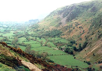
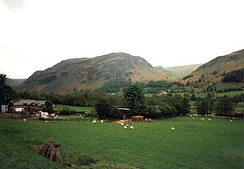
1013 Cwm Rhiwarth character area. Remote and isolated, deeply glaciated valley with clustered small farms with small enclosed fields on lower slopes and valley bottom. Seen here looking eastwards towards Llangynog, showing the narrow tract of flat enclosed land along the floor of the valley. Some of fields extend onto the gentler slopes along the sides of the valleys, although a number of these have now been abandoned and have now become invaded by bracken and gorse. The medium and small-sized farms within the valley are often in small groups and in a number of instances there are suggestions that they were clustered around small open arable fields, probably of early medieval or medieval origin. Photo: CPAT 807.14 (back to map)
Click here for further information about this Historic Landscape Character area
Click here for character area map
|
|
|
|
1014 Waen Llestri character area. Forestry plantation on upper valley edge and upland to south and west of Cwm Pennant, with mining reservoir and leats. Viewed here looking south-westwards up towards Pen y Craig-lâs with regenerated deciduous woodland on the lower slopes and the modern conifer plantation of Llechwedd y Garth above. The lower edges of the forestry overlie abandoned fields probably of late medieval or early post-medieval date running on boundaries marked by the overgrown hedges towards the left. Photo: CPAT 806.22A (back to map)
Click here for further information about this Historic Landscape Character area
Click here for character area map
|
|
|
|
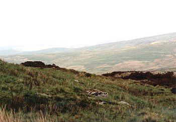
1015 Hafod Hir character area. Steep slopes and crags and rocky hilltops above and between Cwm Pennant and Cwm Rhiwarth, with abandoned fields on lower slopes and flatter land higher up, 19th-century partitioning of upland commons, sheepfolds. The extensive flat and monotonous uplands end abruptly in steep crags and screes on the edges of the deeply glaciated valleys of Cwm Rhiwarth and Cwm Pennant, the view here being of the edge of Cwm Pennant, to the west of Pennant Melangell church. Access to the upland grazing is limited to a number of paths and trackways following gentler stream valleys, which were probably jointly shared by the low-lying farms in the valleys from early times. Photo: CPAT 807.10 (back to map)
Click here for further information about this Historic Landscape Character area
Click here for character area map
|
|
|
|
1016 Rhos y Beddau character area. Unenclosed moorland on Berwyns, common land, with scattered sheepfolds and prehistoric funerary and ritual monuments. Flat and gently undulating moorland, characteristic of the Berwyns, seen here looking eastwards towards Cadair Berwyn, the chair of the giant Berwyn on the far horizon. These were the hills that George Borrow described � 'darkly blue, a rain cloud like ink, hanging over their summits. Oh, the wild hills of Wales, the land of old renown and of wonder, the land of Arthur and Merlin'. Photo: CPAT 807.19 (back to map)
Click here for further information about this Historic Landscape Character area
Click here for character area map
|
|
|
|
1017 Y Clogydd character area. Extensive area of 19th-century enclosure of common land with sheepfolds and metal mining remains on southern edge of Berwyns. Viewed here, looking westwards towards Y Garn, from a point to the north of Llanrhaeadr-ym-mochnant, with some of the fields forming part of the Cefn-côch character area in the foreground. Large areas of the upland pasture were enclosed during the 19th-century and continue to be improved by stone clearance and grassland management. Photo: CPAT 805.10 (back to map)
Click here for further information about this Historic Landscape Character area
Click here for character area map
|
|
|
|
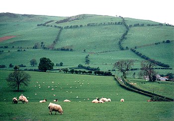
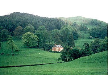
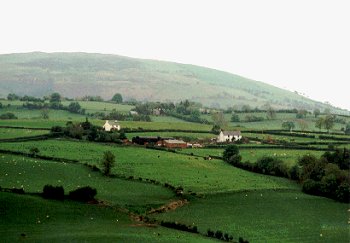
1018 Mynydd-mawr character area. Early post-medieval to 18th/19th-century piecemeal enclosure of isolated upland area on southern edge of the Berwyns. Viewed here, looking northwards, with fields forming part of the Trebrys character area in the foreground. The irregular hedged boundaries probably represent piecemeal clearance and enclosure of the upland pasture probably from the early post-medieval periods onwards. Many of the upland hedges are no longer regularly maintained, resulting in a number of fields being now run into one. Photo: CPAT 803.23 (back to map)
Click here for further information about this Historic Landscape Character area
Click here for character area map
|
|
|
|
1019 Cyrniau character area. Isolated upland area with screes and rocky outcrops, former common land enclosed in 19th century, viewed here from the east. The distinctively pointed hills probably gave rise to the name, meaning 'horns', a place-name element found elsewhere in the Tanat Valley area. The steeper slopes of the hill generally remain as rough grazing, but the lower slopes and flatter areas towards the summit have been improved by stone clearance and grassland management. Photo: CPAT 806.13A (back to map)
Click here for further information about this Historic Landscape Character area
Click here for character area map
|
|
|
|
1020 Penybontfawr character area. 19th-century village and surroundings, with church, chapel, school and inn which grew up at the junction of turnpikes, and superseding more remote medieval parish centre. Penybontfawr, seen here looking westwards with the hills of the Cyrniau character area beyond, is a late 18th- and early 19th-century settlement built at the crossroads of two turnpike roads linking the borderland with west and north-west Wales. The village is unique in Montgomeryshire in being a relatively modern settlement that became an ecclesiastical parish and civil community in its own right. Photo: CPAT 806.3 (back to map)
Click here for further information about this Historic Landscape Character area
Click here for character area map
|
|
|
|
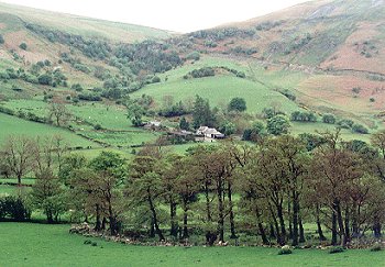
1021 Henfache character area. Large, widely spaced farms on lower ground and more closely spaced, medium-sized farms on lower hill-slopes, late medieval cruck-built halls and field systems. Seen here, looking eastwards, with part of the Mynydd Mawr character area beyond. The farm to the right is Plas-yn-glyn, which includes a 16th/17th-century timber-framed hall, now encased in stone. Along the same trackway to the left is Ty-draw, a dilapidated barn that preserves the remains of a late medieval cruck-built hall house. The buildings, trackway and fields on the lower slopes of the hill represent a late medieval enclosed landscape created by yeoman farmers. Photo:CPAT 805.2 (back to map)
Click here for further information about this Historic Landscape Character area
Click here for character area map
|
|
|
|
1022 Cwm Ffynnon character area. 19th-century enclosure and improvement of upland common on southern edge of the Berwyns. Fields with boundaries formed by drystone walls on the northern slopes of Cwm Rhiwarth, probably of late medieval to early post-medieval date. Many of the walls have now become dilapidated and have been strengthened by the addition of by post and wire fences. Photo: CPAT 808.12 (back to map)
Click here for further information about this Historic Landscape Character area
Click here for character area map
|
|
|
|
1023 Brithdir character area, on the north-facing slopes of Dyffryn Tanat to the south of Llanrhaeadr-ym-mochnant. Small irregular fields and close-set farms on southern slopes of Dyffryn Tanat. The landscape is characterized by small irregular fields with mixed species hedges and tightly clustered small to medium-sized farms and smallholdings, which appears to have been created by gradual woodland clearance during the late medieval and early post-medieval periods with agricultural expansion following the gradual breakdown of medieval systems of land ownership. Photo: CPAT 808.02 (back to map)
Click here for further information about this Historic Landscape Character area
Click here for character area map
|
|
|
|
1024 Glanhafon character area. Narrow tract of low-lying, valley-bottom meadow and marsh towards the eastern end of Dyffryn Tanat. Lines of mature trees represent hedges belonging to the post-medieval enclosure of the low-lying and poorly-drained meadows alongside the Tanat, to the east of Llangynog. Once a number of fields have been run into one in this way there is a tendency for the hedges to eventually disappear, as the older trees die and fail to be replaced by younger saplings. Photo: CPAT 804.16A (back to map)
Click here for further information about this Historic Landscape Character area
Click here for character area map
|
For further information please contact the Clwyd-Powys Archaeological Trust at this address, or link to the Countryside Council for Wales' web site at www.ccw.gov.uk.
Privacy and cookies
|
