Cymraeg / English

|
Tanat Valley Historic Landscape |

|
Character area map |
Historic Landscape Characterisation
The Tanat Valley:
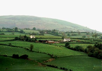
Garthgelynen, Llangynog and Llanrhaeadr-ym-mochnant, Powys
(HLCA 1006)
Closely-spaced, small and medium-sized farms and fields, representing piecemeal expansion and enclosure of lower hill-slopes between the early 16th and 18th centuries.
Historic background
Early activity in the area is reresented by the hoard of nine Bronze Age torcs found on Bryndreinog farm in the 19th century. The area lay within the former ecclesiastical parishes of Llangynog, the lower detached portion Pennant Melangell and the Denbighshire portion of Llanrhaeadr-ym-mochnant parish, and administratively fell within the commote of Mochnant Uwch Rhaeadr.
Key historic landscape characteristics
The area mostly occupies the lower hill-slopes and flatter ground above the valley bottom on the northern side of the Tanat valley between Llangynog and Llanrhaeadr-ym-mochnant, but also includes a stretch of valley-bottom just to the west of Aber Rhaeadr. Broken by occasional steep-sided stream valleys. Predominantly south-facing slopes, between about 130-400m OD.
Reasonably closely-spaced, medium-sized farmsteads, characteristically sited near springs and on the edge of the higher ground, and generally set within their own fields rather than on the public road, with occasional roadside cottages and smallholdings. A significant portion of the farms in the character area have or had cruck-framed hall houses or box-framed timber farmhouses of late 15th- to early 17th-century date, including Tyddyn-llwydion, Cileos-isaf, Tan-y-graig, Trap House and Llwyn-onn, generally subsequently encased in stone, of which many had a secondary use as outbuildings. Sadly, a high proportion of these buildings, including the first three listed here, have disappeared during the later 20th-century. Other farmhouses that have been abandoned and are now in ruins include Siambr. Some of the buildings have been lost due to disrepair and others to as the result of the amalgamation of holdings during the 20th-century. The foundations of timber buildings and the earlier stone buildings tend to be of rounded field-clearance stone, the later 18th-century buildings onwards normally being of quarried stone. Drystone walled farmyard at Llwyn-onn and small walled farmyard and enclosures partly of quarried and partly of field clearance stone at the abandoned farm of Tan-y-graig. 17th to 18th/19th-century stone farmhouses and outbuildings at Arllen-fawr, Plas-Du, Cadnant, Castell-pren, Rhydycul, Glanhafon-uchaf, and Llwyn-onn. Low stone cottage with datestone of 1734 to east of Rhydycul. Late 18th- to early 19th-century century brick farmhouses at Celynog (Clynog) and Efail-wâg, both with stone outbuildings with some weatherboarding, the farmhouses in both instances probably replacing earlier stone-built farmhouses. ?19th-century stone farmhouses at Frongôch and Bryndreinog, the latter partly rendered and with brick dressings. Cluster of 18th/19th-century cottages and smallholdings near mouth of Cwm Glan-hafon, to the east of Llangynog.
Irregularly-shaped, small and medium-sized fields predominantly down to pasture, with boundaries generally either along or at right-angles to the contour. Some older, mature, mixed species hedges, including maple, elder, hazel and hawthorn, others single species, hawthorn hedges. Some hedges low-cut, others overgrown, and some evidently formerly laid. Various field boundary changes including some abandoned boundaries represented by slight banks, lynchets or tree stumps or intermittent lines of trees and shrubs. Occasional newly-planted hedges. Scattered larger oaks and sycamores in field boundaries. Lynchets on sloping ground indicating that ploughing was once much more widespread than it is today. Post and wire stockproof fencing is now widespread. Some stone clearance banks up to 2m across and almost 1m high made of rounded glacially-derived boulders on the shelf of higher ground running westwards from Llanrhaeadr-ym-mochnant towards Llangynog. In some cases there are larger enclosures defined by clearance banks, subdivided by single-species hawthorn hedges. Some areas with dilapidated drystone walls, as near Castell Pren and Llwyn-onn. Some fields on higher slopes of upland area to the north and north-west have now been abandoned. Small areas of semi natural mixed deciduous woodland on steeper slopes. Interestingly, the farm at Arllen-fawr, which can be traced back to at least the second half of the 16th century, is one of only a small number of instances in the area where a lowland farm can be directly linked to a probable upland summer dwelling known as Hafoty Arllen-fawr on the moorland about 9km to the south-west at a height of 450 metres OD.
Public roads, green lanes and trackways running in hollow-ways evidently, occasionally stone-revetted, particularly on steeper slopes. Some of the hollow-ways are up to 4m deep and are evidently of some antiquity, having been formed in the centuries before the installation of road drainage during the 20th century. Some of the green lanes between farms are now abandoned and overgrown. The now dismantled Tanat Valley Light Railway cuts a distinctive course across the southern side of the area, partly on the flat, partly in a cutting and party on an embankment and including the site of the former station at Pedairffordd. Occasional surface evidence of the Vyrnwy aqueduct which cuts across the area, including the Cileos Valve House and the deep cutting west of Llanrhaeadr-ym-mochnant.
Sources
Britnell 1994aBritnell & Suggett forthcoming
Hancock 1877; 1878; 1879
Haslam 1979
For further information please contact the Clwyd-Powys Archaeological Trust at this address, or link to the Countryside Council for Wales' web site at www.ccw.gov.uk.
Privacy and cookies