Cymraeg / English

|
Tanat Valley Historic Landscape |

|
Character area map |
Historic Landscape Characterisation
The Tanat Valley:
Rhos-y-beddau, Llangynog and Llanrhaeadr-ym-mochnant, Powys
(HLCA 1016)
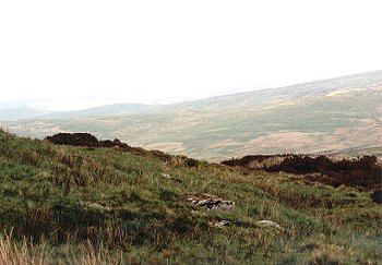
Unenclosed moorland on Berwyns, common land, with scattered sheepfolds and prehistoric funerary and ritual monuments.
Historic background
Unenclosed common land within the medieval ecclesiastical parishes of Llangynog and Llanrhaeadr-ym-mochnant.
Practically the only visible evidence of human activity is represented by occasional stone sheepfolds and mineral trials around the mountain edge, and Bronze Age funerary and ritual sites, notably including the complex comprising the Rhos-y-beddau and Cwm-rhiwiau stone circles, stone avenue and burial cairns on the moorland above Pistyll Rhaeadr.
Key historic landscape characteristics
Unimproved moorland accessed by roads trackways and footpaths from the head of Cwm Rhiwarth and Cwm Blowty with waterlogged, boggy areas and extensive heather, between a height of about 350-800m OD. Topographically, the mountaintop is the remnant of a peneplain with a flattened skyline, broken by the deeply glaciated valleys to the south, the steep and unenclosed upper sides of which are included in the character area. The bleak and dramatic scenery has greatly impressed travellers: George Borrow taking a short cut from Pistyll Rhaeadr across the Berwyns to Bala described it as follows:
Here I turned and looked at the hills I had come across. There they stood, darkly blue, a rain cloud like ink, hanging over their summits. Oh, the wild hills of Wales, the land of old renown and of wonder, the land of Arthur and Merlin. Wild Wales 1862
Sources
Grimes 1963For further information please contact the Clwyd-Powys Archaeological Trust at this address, or link to the Countryside Council for Wales' web site at www.ccw.gov.uk.
Privacy and cookies