Cymraeg / English

|
Tanat Valley Historic Landscape |

|
Character area map |
Historic Landscape Characterisation
The Tanat Valley:
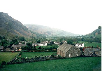
Llangynog, Llangynog, Powys
(HLCA 1010)
Medieval church site, mining village with 18th/19th-century cottages, inn and chapels, associated with lead mining, slate quarrying and roadstone industries.
Historic background
Early activity is represented by a Bronze Age bronze axe found in the 19th century. The area lay within the medieval ecclesiastical parish of Llangynog and in the ancient commote of Llanrhaeadr Uwch Rhaeadr, Montgomeryshire. The church, dedicated to St Cynog, is first recorded in the 13th century but as in the case of a number of other medieval churches in Dyffryn Tanat there is any clear evidence of the nature or form of a nucleated settlement that it might have been associated.
The history of the settlement effectively begins with the development of the lead mines which witnessed a rapid rise early in the 18th century, followed by a long decline to the end of the 19th century. Production reached its peak during the first half of the 18th century, much early than many of the other famous mines of mid Wales, and at one time ranked as the most productive lead mines in the region. Probable evidence of early mining activity of prehistoric, Roman or medieval date is represented by early workings (opencuts and stopes) on the south side of Craig Rhiwarth above Llangynog.
Tourism is now an important industry and there is a caravan park just to the east of the village
Key historic landscape characteristics
The character area includes the valley-bottom and valley sides at the junction of the Tanat valley with Cwm Pennant, Cwm Rhiwarth, and the southern slopes of Craig Rhiwarth, and ranges in height from between about 160m at Llangynog to a height of about 450m north of Craig Rhiwarth.
The nucleus of the village around the church and across the river at Pentre includes 18th/19th-century terraced cottages, 19th chapels, the New Inn of 1751, 19th-century school and church rebuilt in 1791-92 and greatly renovated in 1894, with mid and later 20th-century housing estates on west side and miners' cottages with small walled gardens on the hillside to the north-west, strung out along the road to Bala.
Problems of communication continually beset the early development of extractive industries though this was to some extent improved by the construction of the turnpike roads through the valley and across the hills to Bala in the second half of the 18th-century. The opening of the terminus of the Tanat Valley Light Railway at Llangynog in 1904 came too late to revitalize the local mineral industry, but gave some stimulus to the quarrying industry, however, including mining at Llangynog for barytes in 1916, and slate quarrying. The increasing use of road transport in the 1940s and 1950s eventually led to the demise of the railway, the terminus at Llanrhaeadr eventually closing in 1951.
Important and in some instances well-preserved remains of the extraction and processing of lead ore at Llangynog survive on the south side of the village, much destroyed by later stone quarrying. Most of the ores from the mined in the Llangynog district were smelted outside the valley, at either Pool Quay where a smelter was built by the earl of Powis in 1706, or Benthall, Coalbrookdale, and later to Minera, although a smelter was in operation on a smaller scale at Llangynog itself in the 1750s. Production declined dramatically during the second half of the 18th century, though small-scale working continued intermittently until 1912.
Significant remains of slate quarrying survive on the side of the hills to the west of the village and again on the southern slopes of Craig Rhiwarth to the north of the village. Slate quarrying appears to have begun in the late 16th-century, thrived during the later 18th-century and declined towards the end of the 19th century, finally ceasing in 1941. Stone quarrying probably began at Llangynog from the late 16th. Quarrying for roadstone began on a more commercial scale began at a number of sites in the immediate neighbourhood of Llangynog in about 1910 with the impetus of the Tanat Valley Light Railway, declining during the 1930s and eventually ceasing production in the 1950s.
Sources
Haslam 1979Silvester 1992
Walters 1993
Williams 1985
Wren 1968
For further information please contact the Clwyd-Powys Archaeological Trust at this address, or link to the Countryside Council for Wales' web site at www.ccw.gov.uk.
Privacy and cookies