Cymraeg / English

|
Tanat Valley Historic Landscape |

|
Character area map |
Historic Landscape Characterisation
The Tanat Valley:
Llangedwyn, Llangedwyn, Powys
(HLCA 1001)
Hilly, wooded and ornamental landscape, with large houses and gardens and estate farms with rolling pasture.
Historic background
Early settlement and land-use is indicated by several cropmark enclosure sites and a pit alignment on the valley bottom and by an earthwork enclosure on the small hillock near Plas-uchaf which possibly represent Iron Age farmsteads. Llangedwyn was a single township in the commote of Mochnant Is Rhaeadr, Denbighshire, having originally, like Llanarmon-mynydd-mawr, been a dependent chapelry within the ecclesiastical parish of Llanrhaeadr-ym-mochnant. Despite this, there is no clear evidence for the existence of early nucleated at Llangedwyn during the medieval period, and most the surviving settlement evidence belongs to the 17th-century onwards. The present church of St Cedwin's church, Llangedwyn, was rebuilt under the patronage of the Williams-Wynn family in 1869-70, but evidence of early medieval activity is represented by a decorated cross slab, set up against the eastern end of the church.
Key historic landscape characteristics
Broken, hilly landscape, predominantly south-facing, between about 100-250m OD. As late as the early 14th century the greater part of parish of Llangedwyn is said to have continued to be wooded and still today the area includes large areas of semi-natural mixed deciduous woodland and coniferous plantation on the steeper slopes including Coed Mawr, The Warren, Wenallt and Yr Allt, balanced by the extensive mixed woodland of Coed Pen-isa'r-mynydd outside the historic landscape area on the southern side of the river Tanat. The meadow land alongside the river is similar to the Glantanat character area but is included here because of its visual importance to the ornamental aspects of the Llangedwyn character area, a feature enhanced by the scattered mature oaks and the plantation at Coed Tan Llwyn, which give this low-lying area a park-like character.
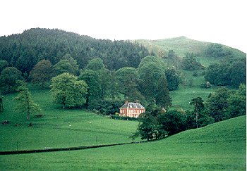
Present-day settlement is dominated by Llangedwyn Hall, probably the only grand Tudor or Renaissance building to be built in Dyffryn Tanat, being a late 17th- or early 18th-century remodelling of a late 16th- or early 17th-century building, inherited by the Williams-Wynns in 1718, with walled gardens, estate buildings, stable block and the octagonal structure with loose boxes in a paddock to the east of the house. Other large houses include Bryn-y-gwalia in woodland to the east and Plas-uchaf, the imposing early 18th-century brick house with sandstone dressings on the lower slopes of Llwyn Bryn-dinas on the western side of the character area - Plas Uchaf ('Place Xcha') being incidentally one of only two places in Dyffryn Tanat named on Robert Morden's map of North Wales published in 1695. Other settlement includes the Pen-y-bryn has a 19th-century stone and brick farmhouse with brick outbuildings which include elements of a model farm, and the house and estate cottages at Tyn-y-rhos in the hills to the north, and the mid and later 20th-century housing estate on the main road, with its red-brick school of 1897 and rendered and red-brick village hall of 1907.
The area includes substantial areas of improved pasture as well as woodland. On the hills to the north are large rolling fields of pasture with low-cut single-species, hawthorn hedges, probably representing post-medieval woodland clearance and subsequent 18th/19th-century enclosure of pasture, with scattered mature oaks within some fields lending a park-like character. The large, flat and low-lying rectangular fields alongside the river Tanat to the south, are similar to those in the Glantanat character area to the west. The field boundaries are of low-cut hawthorn hedges, and represent 19th-century enclosure of former common meadow. Squared stone gateposts to field entrances on the main road.
The principal road running through the area is the mid 18th-century turnpike from Knockin to Llanrhaeadr, observing and observed by the gardens and entrance drive to Llangedwyn Hall. The lane linking the farms to the north of Llangedwyn appears to represent a more ancient route, and runs for part of its course in substantial hollow-way that has been cut through shaley outcrops in places. The large 19th-century stone road bridge at Pont Llangedwyn and the site of the halt on the dismantled Tanat Valley Light Railway also fall within the character area, the present course of the river Tanat just to the east of Llangedwyn having been straightened to prevent it from undermining the railway.
Industry is limited to the 18th/19th-century complex at Llangedwyn Mill.
Ornamental landscapes are an important feature of the Llangedwyn character area, and notably including the listed gardens at Llangedwyn Hall created by Sir Watkin Williams-Wynn of Wynnstay, constructed in the early 18th century, and including terraces set out on the sloping grounds (featuring in the verses of Robert Southey, Poet Laureate, in the early 19th century), walled kitchen garden as well as the managed woodland on the hillside above. Also of importance are the prominently sited gardens and parkland with mature deciduous and conifer trees around Plas-uchaf, framed by the picturesque backdrop of Llwyn Bryn-dinas whose prehistoric ramparts enhance its craggy skyline.
Sources
Cadw 1995;1999Hubbard 1986
Musson et al 1992
Thomas 1881
Wren 1968
For further information please contact the Clwyd-Powys Archaeological Trust at this address, or link to the Countryside Council for Wales' web site at www.ccw.gov.uk.
Privacy and cookies