Cymraeg / English

|
Tanat Valley Historic Landscape |

|
Character area map |
Historic Landscape Characterisation
The Tanat Valley:
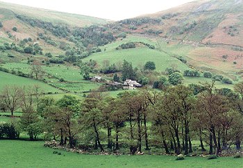
Cwm Blowty, Llanrhaeadr-ym-mochnant, Powys
(HLCA 1012)
Remote and isolated, deeply glaciated valley with clustered small farms, some abandoned, with small enclosed fields on lower slopes and valley bottom, dramatic waterfall, associations with the giant Cawr Berwyn.
Historic background
Part of the valley fell within the Denbighshire portion of the medieval ecclesiastical parish of Llanrhaeadr-ym-mochnant, but the township of Cwm Blowty formed a detached portion of the parish of Pennant Melangell, Montgomeryshire. Administratively, it lay within the commote of Mochnant Is Rhaeadr, Denbighshire. Gwernfeifod, a farm at a height of about 380m OD in Cwm-ffynnon, branching from the northern side of Cwm Blowty, was formerly a medieval grange belonging to Valle Crucis Abbey. Significantly, perhaps, the farm includes St Dogfan's well, the holy well dedicated to the patron saint of the parish church at Llanrhaeadr-ym-mochnant, in whose parish it lay. The name of the farm includes the place-name element meifod (May dwelling) suggesting that at an earlier period it was a summer dwelling.
Key historic landscape characteristics
Deeply glaciated valley with the Afon Rhaeadr running along its floor, extending in an unbroken line for about 6km to the north-west of Llanrhaeadr-ym-mochnant. The valley is narrow and constricted at its mouth, just outside Llanrhaeadr, its floor broadening to about 400m across towards the head of the valley. The valley floor rises from a height of about 170m OD near Llanrhaeadr to about 300m near the foot of the waterfall, the hills around the edge of the valley rising precipitously to a height of over 500m OD. Some poorly-drained areas on valley bottom.
Clustered small and medium-sized farms generally on the lower sides of the valley bottom, often near the roadside, including the 17th/19th-century stone farmhouse and outbuildings at Cefnderwen, 17th/18th-century complex of farmhouse and outbuildings at Maes-y-bwch, the farmhouse now dilapidated and replaced by a modern brick farmhouse, 18th-century stone farmhouse and outbuildings at Tyn-y-ddol and Gorwallt, Tyn-y-wern, Tan-y-graig and Tyn-y-celyn. A number of the more less accessible farms on sloping ground on the southern side of the valley are now deserted, including Tyn-y-llwyn, and abandoned cottage at Gardden-fâch on the northern side of the valley. Cluster of late 18th- to early 19th-century cottage encroachments on former common land in the narrow and steep-sided portion of the valley at Commins, the buildings being of quarried as well as rounded boulders, with Carmel chapel built in 1836 and rebuilt in 1861, now converted to house.
Present-day land-use is exclusively pasture. Some mixed-species roadside hedges, with evidence of former traditional hedgelaying. Occasional, roughly-hewn stone gateposts on some field entrances. On the gentler slopes on the south-east side of the valley are medium-sized rectilinear fields and some earlier fields with curving boundaries defined by stone banks and drystone walls up to 1.5m across and 1m high formed from stone clearance, many of which are now dilapidated, probably representing 17th/18th-century enclosure. Some of the banks and walls support low-cut hedges, overgrown hedges or either intermittent trees and shrubs and in some instances. In some cases here and on the northern side, towards the head of the valley, larger enclosures defined by stone clearance banks have been subdivided by single-species (hawthorn) hedges without banks. Clearance cairns of uncertain date on sloping ground in some stonier areas. Relict field banks in some instances where several fields have been run into one.
Small, irregular fields with drystone walls of probable medieval and late medieval fields date on the valley floor and sides in the area from the west of Commins to the head of the valley, some with lynchets indicating former intensive ploughing. The walls, some of which are dilapidated, are of rounded boulders and derived from the clearance of stone in the valley bottom. Several upright slate slab walls towards head of valley. The flatter areas of farmland and field-names including the element maes in the neighbourhood of Maes-y-bwch farms suggest the presence of former areas of medieval open arable sharelands in this area.
Numerous sheepfolds towards the margins of the enclosed land. Access to the surrounding upland grazing is principally up the stream courses at the head of the valley and along a number of other lateral stream valleys including Cwm-ffynnon north of Maes-y-bwch. A modern upland access road zigzagging across the hillside west of Tan-y-graig follows the course of a probably more ancient route partly represented by a braided trackway.
Areas of semi-natural mixed deciduous and oak woodland on steeper slopes along the valley sides and in Cwm-ffynnon, with stands of alders along stream banks and along the banks of the Afon Rhaeadr. Small coniferous plantations and scattered larger trees.
Ornamental conifers and box shrubs around Pen-y-bryn Hall and its drive, high on the north side of the valley.
The valley is most famous for Pistyll Rhaeadr, the impressive waterfall at the head of the valley and one of the attractions on the itinerary of visitors to North Wales since the later 18th century. The road along the valley was a turnpike built to assist tourists at this time, its construction involving the erection of the single-arched stone bridge across Nant Cwm-ffynnon at Maes-y-bwch. The public road is generally scarped into the slope, and is revetted in places by rounded boulders. Gravestone-shaped slate milestones on northern side of road erected by Wrexham District, Denbighshire County Council in 1903. The three enormous boulders at the foot of the waterfall are associated with the legend of the giant Cawr Berwyn, his wife and his maid.
Sources
Britnell 1994aEvans 1994
Hancock 1871; 1872; 1873; 1875
Haslam 1979
Richards 1934b
Williams 1990
For further information please contact the Clwyd-Powys Archaeological Trust at this address, or link to the Countryside Council for Wales' web site at www.ccw.gov.uk.
Privacy and cookies