CPAT logo


Cymraeg / English
Back Home
Historic Landscapes

Historic Landscape Characterisation

Vale of Llangollen and Eglwyseg


Introduction

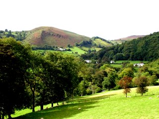
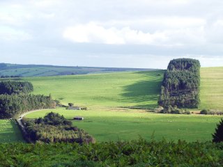
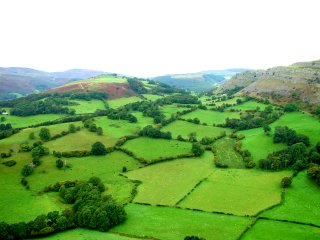
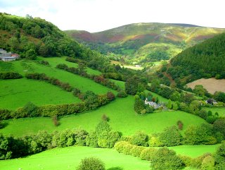
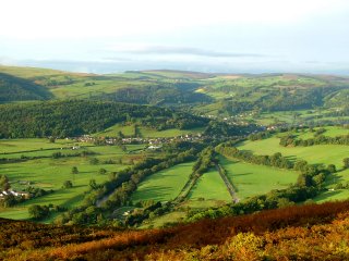
The following description, taken from the Historic Landscapes Register, identifies the essential historic landscape themes in the Vale of Llangollen and Eglwyseg historic landscape area.

The Vale of Llangollen in North East Wales presents a remarkable visual combination of stark natural landforms and ancient and modern man-made features. Geomorphologically the vale is a broad rift valley, dominated on the north by the towering limestone cliffs of Eglwyseg Mountain. The cliff tops gradually gain in height from 300m above OD at their southernmost point overlooking the middle of the vale, to 450m above OD at their northernmost point overlooking the upper reaches of the narrow tributary valley of the Eglwyseg river. On the south side of the vale, the slopes rise steeply to 400m above OD along the summit of the ridge that divides the vale from the Ceiriog valley to the south.

CPAT PHOTO 1766-08

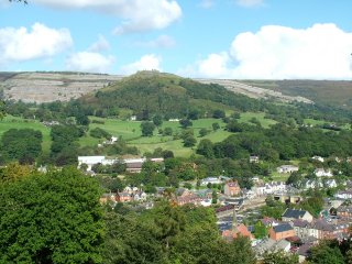
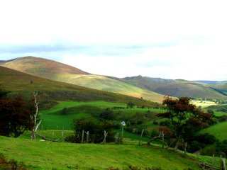
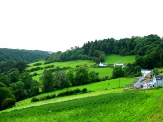
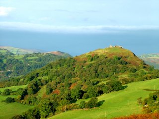
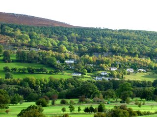
Llangollen, Castell Dinas Brân, and Creigiau Eglwyseg. Photo: CPAT 1766-08.

The flat floor of the vale is about 100m above OD and contains the winding course of the River Dee, although at Llangollen, the vale narrows into what is more characteristically a river valley, first turning north and then west to continue beyond the part of the vale described here. Overlooking Llangollen from the east are the imposing remains of Castell Dinas Brân, a medieval masonry castle located within the earthworks of an earlier, Iron Age hillfort. The site occupies the summit of a steep sided, conical shaped hill which rises spectacularly to 320m above OD out of the valley floor and is topped by the picturesque ruins of the castle which was possibly built by Gruffydd ap Madoc, son of the founder of Valle Crucis Abbey.

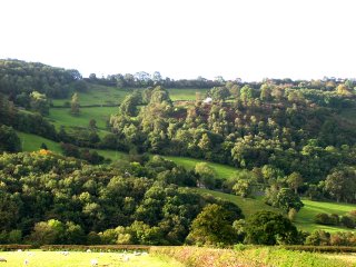
The Cistercian abbey of Valle Crucis lies near the confluence of the Eglwyseg and the Dee north of Llangollen, and was founded by Madog ap Gruffydd in 1201 as a colony of Strata Marcella near Welshpool. The now ruined abbey buildings are typical of many Cistercian foundations, lying in a secluded river valley surrounded by farmland. Local folklore associates Valle Crucis with Owain Glyn Dwˆ r who disappeared in about 1410 after the failure of his rebellion against the English.

The fragmentary 9th-century cross, the Pillar of Eliseg, is set on a small circular mound which is perhaps a Bronze Age barrow, just to the north of the Abbey. The cross has a Latin inscription which is now too eroded to read, but according to a transcription of 1696, celebrated the glories of the house of Powys and recorded that the stone was erected by Cyngen in honour of his great-grandfather Eliseg.

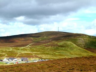
At the northern end of the Eglwyseg valley, at World’s End, lies the impressive timber-framed manor house Plas Uchaf which bears a date of 1563. West of the Eglwyseg valley, the northern limit of the landscape is dominated by the majestic sweep of the Horseshoe Pass where the road finally climbs over Maesyrychen Mountain, past abandoned 19thcentury slate quarries, and on towards the Vale of Clwyd.

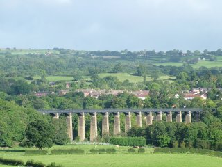
The Dee valley has always been a major communications route and bears the evidence of successive innovations in the history of transport. Perhaps the most notable of these is the Llangollen branch of the Shropshire Union Canal, constructed by Thomas Telford and opened in 1805. From its source at the Horseshoe Falls the canal follows the northern side of the valley before crossing the Dee with the dramatic Pontcysyllte aqueduct, overshadowing its medieval ‘counterpart’ which carried the road over the River Dee. At the northern end of the aqueduct is Trevor Wharf where Telford reputedly stayed during its construction. Telford was also responsible for the construction of the new Holyhead Road, now the A5, which runs through the vale and was recently officially marked as a historic route.

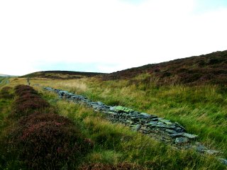
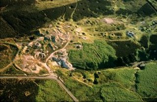
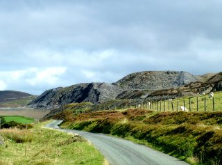
The vale also bears the scars of an industrial past. The limestone cliffs of Eglwyseg have been quarried for centuries both for building stone and as a source of lime. Several lead mines drove adits directly into the cliffs, and the remains of both industries are still to be seen. The north west of the area displays the remains of slate quarrying, including inclines and parts of an embanked tramway, while its southern end is dominated by the industrial complexes of Cefn-mawr and Acre-fair (both currently outside the area described here).

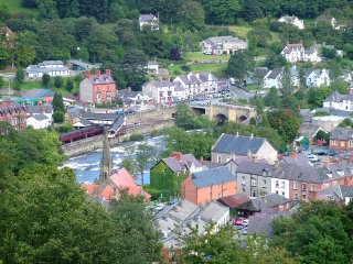
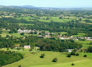
Llangollen itself straddles the Dee via the arched bridge built about 1500. The historic core of the town lies on the southern side, focusing on the church and the river crossing. Later development occurred largely because of the woollen i n d u s t r y, which used the natural power source of the Dee to drive several mills, and then during the 19th century because of the coming of the railway which, although finally closed to traffic in 1968, has now been partly reopened for tourists, as the Dee Va l l e y R a i l w a y. On the outskirts of the town is Plas Newydd, the home of the Ladies of Llangollen who at the turn of the 19th century were renowned patrons of the arts and did much to promote a resurgent interest in Welsh culture. Llangollen has built on these artistic traditions and is now known throughout the world for the International Eisteddfod held annually in the t o w n .

The Making of the Vale of Llangollen and Eglwyseg Landscape

The forces which have helped to form this landscape of special historic interest in Wales are outlined in the following sections.

Environments and Boundaries

Land Use and Settlement

Industrial Landscapes

Transport and Communications

Cultural Landscapes

Sources of information

Information on the Vale of Llangollen and Eglwyseg can be found in various published sources.

Published sources of information
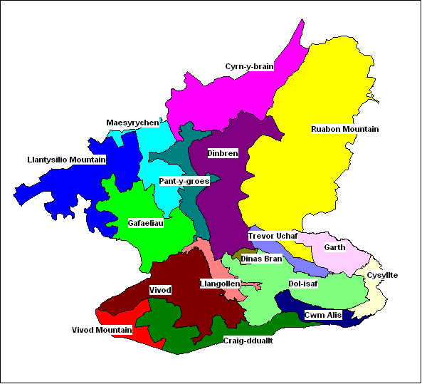
Character areas

The following historic landscape character areas have been defined within the historic landscape area.

Click for landscape description

Character areas defined in the Vale of Llangollen and Eglwyseg Historic Landscape


CPAT PHOTO 1766-10

1140 Vivod Mountain character area. Former 19th-century conifer woodland south of Vivod now forming heather moorland managed for game shooting. Photo: CPAT 1766-10. (back to map)

Click here for further information about character area

Click here for character area map

CPAT PHOTO 1766-184

1141 Gafaeliau character area. Isolated tract of the Dee valley west of Llangollen, with lowland and upland margin farms and fieldscapes of medieval and later origin; Victorian country houses, parkland and gardens, estate farms and cottages; small nucleated settlements partly associated with former slate mining. Photo: CPAT 1766-184 (back to map)

Click here for further information about this character area

Click here for character area map

CPAT PHOTO 1766-259

1142 Llantysilio Mountain character area. Extensive, unihabited upland moorland ridge mostly forming unenclosed common land, with prehistoric ridge-top hillfort and burial mounds, formerly partly managed as a grouse moor. Photo: CPAT 1766-259 (back to map)

Click here for further information about this character area

Click here for character area map

CPAT PHOTO 1766-267

1143 Cyrn-y-brain character area. Unihabited upland moorland ridge mostly forming unenclosed common land, with prehistoric burial mounds, formerly partly managed as a grouse moor. Photo: CPAT 1766-267. (back to map)

Click here for further information about this character area

Click here for character area map

RCAHMW 93-CS-1550

1144 Ruabon Mountain character area. Extensive, unihabited upland moorland plateau mostly forming unenclosed common land, managed as a grouse moor, with clustered and more isolated Bronze Age burial and ritual monuments and the remains of metal mining and prospecting in the 19th century. Photo: Crown Copyright: RCAHMW 93-CS-1550. (back to map)

Click here for further information about this character area

Click here for character area map

CPAT PHOTO 1766-91

1145 Maesyrychen character area. Open moorland with extensive remains of predominantly 19th-century slate quarries, waste heaps, tramways and inclines. Photo: CPAT 1766-91. (back to map)

Click here for further information about this character area

Click here for character area map

CPAT PHOTO 1766-250

1146 Vivod character area. Irregular fieldscapes and woodland in stream valleys and hillslopes south and west of Llangollen with 19th-century estate, estate farms and cottages. Photo: CPAT 1766-250. (back to map)

Click here for further information about this character area

Click here for character area map

CPAT PHOTO 1766-79

1147 Craig-dduallt character area. 19th-century enclosed upland and woodland bordering southern side of the Vale of Llangollen with evidence of early prehistoric activity. Photo: CPAT 1766-79. (back to map)

Click here for further information about this character area

Click here for character area map

CPAT PHOTO 1766-252

1148 Cwm Alis character area. Broadleaved woodland, scrub and patches of small irregular fields on steep-sided valley slopes on the southern side of the Vale of Llangollen. Photo: CPAT 1766-252. (back to map)

Click here for further information about this character area

Click here for character area map

CPAT PHOTO 1766-315

1149 Dinbren character area. Relatively remote area of dispersed farms and woodland bordering Eglwyseg Mountain with traces of quarrying and mining in the later 19th and early 20th centuries. Photo: CPAT 1766-315. (back to map)

Click here for further information about this character area

Click here for character area map

CPAT PHOTO 1766-303

1150 Dinas Brân character area. Steep, conical hill with gaunt, picturesque ruins of medieval castle inside prehistoric hillfort defences, overlooking Llangollen and visually dominating the Vale of Llangollen. Photo: CPAT 1766-303. (back to map)

Click here for further information about this character area

Click here for character area map

CPAT PHOTO 1766-144

1151 Pant-y-groes character area. Anciently enclosed farmland and scattered farms in the valley of the Eglwyseg river, below the Horseshoe Pass, including the historically important remains of Eliseg’s Pillar and Valle Crucis abbey and significant remains of the slate industry. Photo: CPAT 1766-144. (back to map)

Click here for further information about this character area

Click here for character area map

CPAT PHOTO 1766-01

1152 Llangollen character area. Small market town of early medieval and medieval origins now forming an important regional tourist centre exploiting its canal and railway heritage. Photo: CPAT 1766-01. (back to map)

Click here for further information about this character area

Click here for character area map

CPAT PHOTO 1766-300

1153 Dol-isaf character area. Visually outstanding valley floor of the steep-sided Dee valley between Llangollen and Pontcysyllte, with fieldscapes, golf-course and prominent gardens and parkland areas. Photo: CPAT 1766-300. (back to map)

Click here for further information about this character area

Click here for character area map

CPAT PHOTO 1766-370

1154 Trevor Uchaf character area. Rural landscape of dispersed farms and irregular fields of medieval and late medieval origin with 18th- and 19th-century industrial remains associated with the lime industry and dispersed linear settlement originally of quarrymens’ cottages. Photo: CPAT 1766-370. (back to map)

Click here for further information about this character area

Click here for character area map

CPAT PHOTO 1766-26

1155 Garth character area. Sloping ground on south-eastern edge of Ruabon Mountain with rural landscape of medieval and late medieval origin partly superimposed by 19th and 20th-century industrial remains and dispersed settlement at Garth. Photo: CPAT 1766-026. (back to map)

Click here for further information about this character area

Click here for character area map

CPAT PHOTO 1766-50

1156 Cysyllte character area. Area of 19th and early 20th century industrial expansion including limestone quarrying, lime burning and industrial ceramics and associated workers' housing spanning the Dee valley to either side of the Pontcysyllte Aqueduct. Photo: CPAT 1766-50. (back to map)

Click here for further information about this character area

Click here for character area map


For further information please contact the Clwyd-Powys Archaeological Trust at this address, or link to the Countryside Council for Wales web site at www.ccw.gov.uk.


Privacy and cookies
1150 1154 1156 1152 1152 1152 1148 1140 1155 1151 1145 1145 1147 1141 1153 1142 1146 1143 1149 1144