Cymraeg / English

|
Vale of Llangollen Historic Landscape |

|
Character area map |
|
|
More photographs |
Historic Landscape Characterisation
The Vale of Llangollen:
Vivod Mountain
Llangollen Community, Denbighshire
(HLCA 1140)
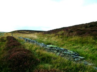
Former 19th-century conifer woodland south of Vivod now forming heather moorland managed for game shooting.
Historic background
Early activity is represented by two Bronze Age burial mounds, on sited on a hilltop and one on the crest of a hill, which may which might indicate clearance for grazing domestic animals in the early prehistoric period. By the 7th or 8th century the area fell within the Welsh kingdom of Powys, and from the late 12th century within the subdivided northern portion of the kingdom, known as Powys Fadog. Following the Edwardian conquest of Wales in the late 13th century the area to the south of the Dee fell within the newly-created marcher lordship of Chirkland. Following the Act of Union in 1536 it formed part of the newly created county of Denbighshire.
Key historic landscape characteristics
Gently undulating land between a height of 390–500 metres south of Vivod, the moorland edge being defined by drystone walls in places. Much of the area formed a conifer plantation felled during the first half of the 20th century which has now reverted to heather moorland, the pattern of trackways in the area reflecting earlier rides within the woodland. Lines of shooting butts relate to the modern management of much of the area for game shooting which has been carried out since the 1950s.
Sources
CPAT Historic Environment Record; Davies 1929For further information please contact the Clwyd-Powys Archaeological Trust at this address, or link to the Countryside Council for Wales' web site at www.ccw.gov.uk.
Privacy and cookies