Cymraeg / English

|
Vale of Clwyd Historic Landscape |

|
Character area map |
Historic Landscape Characterisation
The Vale of Clwyd:
Felin-ysguboriau, Ruthin and Llanfair Dyffryn Clwyd, Denbighshire
(HLCA 1034)
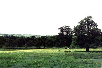
Large dispersed farms and mills in landscape of medium to large-sized fields of low-lying but well drained pasture between the Afon Clwyd and the Dwr Iāl stream on the southern outskirts of Ruthin.

Historic background
Falling largely within the medieval ecclesiastical parish of Llanynys, within the cantref of Dyffryn Clwyd. Early settlement or possibly burial of pre-Roman Iron Age date is represented by a pair of bronze spoons found during the construction of the former railway to the south of Ffynnogion. Evidence of Roman agricultural settlement and land-use is represented by evidence in the Brynhyfryd Park area on the eastern side of Ruthin and there have also been occasional Roman finds elsewhere in the area including several finds of gold and silver coins near Llanrhudd. The church of St Meugan's at Llanrhudd lies on a bluff overlooking the Dwr Iāl stream has by tradition been thought to have been founded in the 6th-century. It was certainly in existence by the 13th-century, becoming the mother church of Ruthin when the castle and town were begun. High status medieval settlement appears to be represented by the moated site just to the north of Ffynnogion.
Key historic landscape characteristics
Gently undulating, relatively well-drained valley bottom, between about 70-90m OD, between the Afon Clwyd on the west and the Dwr Iāl stream on the east. Dominated by the higher ground below Ruthin to the north and by the higher ground on the western side of the vale to the west.
Settlement is limited to a relatively small number of widely dispersed, well-established farms such as Ffynnogion, a late medieval storied half-timbered house, rendered externally, with 18th/19th-century brick outbuildings and stone-walled yard, and Merllyn with a now derelict farmhouse with stone-built ground floor and brick upper storeys and again with brick outbuildings, and stone outbuildings at Felin-ysguboriau/Castle Park Farm.
Medium to large fields predominantly laid out to pasture, with some fodder crops, with low-cut hawthorn hedges, the boundaries of a number of earlier larger fields being cut by the improved turnpike and later roads leading into Ruthin from the south and south-east, the course of earlier road sometimes represented by abandoned hollow-ways. The slightly higher ground towards Llanrhudd in the area of Maes-y-llan and Ty'n-y-caeau farms seems likely to have been the location of arable fields associated with the medieval town of Ruthin, and may be the concentric field patterns on the eastern and south-eastern sides of Ruthin. Scattered larger oaks, ash and holly, and with alders along watercourses. Willow beds to the south of Felin-ysguboriau.
The now disused railway forms a significant element of the townscape of eastern Ruthin and can still be traced in places to the south of the town, former station buildings surviving at Eyarth Old Station, to the north-west of Llanfair Dyffryn Clwyd.
Industry represented by the former mill at Llanrhudd Mill of the Dwr Iāl, and by Felin-ysguboriau and associated mill leat taken from the Afon Clwyd. The former Ruthin town mill was fed by a second leat taken off the Clwyd just to the north of Felin-ysguboriau.
Castle Park, an important area of parkland and land of parkland character immediately to the south of Ruthin listed in Register of Landscapes, Parks and Gardens, is fenced along the public road by iron railings. The course of the pre-1859 Corwen to Ruthin road and single-span road-bridge are visible in the parkland. There is also some land of parkland character to the south of Merllyn farm.
Sources
Cadw/ICOMOS UK 1995Hubbard 1986
For further information please contact the Clwyd-Powys Archaeological Trust at this address, or link to the Countryside Council for Wales' web site at www.ccw.gov.uk.
Privacy and cookies