Cymraeg / English

|
Bro Trefldwyn Historic Landscape |

|
Character area map |
Historic Landscape Characterisation
Bro Trefaldwyn:
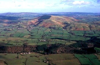
Aldress
Churchstoke, Powys and Chirbury, Shropshire
(HLCA 1071)
Scattered medium-sized farms in ordered landscape of irregular sloping fields set out along the contour, with more recent enclosures along the upland margin.
Historic background
The northern part of the character area fell within the township of Priest Weston in the ecclesiastical parish of Chirbury, Shropshire. The southern tip fell within the township and parish of Churchstoke, Montgomeryshire. Early prehistoric activity in the area is indicated by several burial cairns of Bronze Age date on the higher ground to the east. Settlements are recorded at both Priest Weston (Westune) and Churchstoke (Cirestoc) in the Domesday Book of 1086. Of six manors at Priest Weston four were said to have been waste at the time of the conquest in 1066, presumably because of hostilities between the English and Welsh. Most of the lower-lying land had been enclosed by at least the early 19th century, the present-day field pattern showing relatively little change since at least the mid 19th century. Higher ground on Lan Fawr in the parish of Churchstoke was still unenclosed common at the time of the Tithe, parcels of higher land just to the north of Priest Weston also being listed as 'Old Enclosure' in the Tithe.Key historic landscape characteristics
Gently sloping farmland looking westwards, in a relatively secluded 'valley' between Priest Weston and Churchstoke, bounded by Marrington Dingle on the west, and extending onto the western slopes of the upland area of Lan Fawr on the east, dissected by a number of streams running off the upland area to the east which join the Camlad. Most of the lower-lying ground lies between 160-220m OD, with the uplands on the eastern side of the character area reaching a height of about 400m OD. The underlying solid geology is relatively diverse. The lower ground on the western side of the character area is composed of relatively narrow north-south bands of Ordovician mudstones, shales and grits and flaggy calcareous sandstone, with number of thin, often brecciated, beds of volcanic tuffs. The upland mass of Lan Fawr is formed of intrusive igneous andesites and dolerites. Fine silty, clayey and loamy stagnogley soils, subject to some seasonal waterlogging.Apart from the hamlet of Priest Weston, settlement is largely confined to scattered small and medium-sized farms spaced at distances of between 600-700m, some set in their own fields and some on public roads. An earlier building horizon is represented by the 16th/17th-century timber-framed farmhouse and cottage at Cwmdulla Farm. Stone buildings are common elsewhere, with late 17th to early 19th-century uncoursed stone cottages, houses, farmhouses and barns in the hamlet of Priest Weston, a number of which like the Old Post Office and the Old Smithy have undergone several different changes in use. An earlier horizon of domestic timber buildings is represented by the possibly 15th or early 16th-century buildings at the Tin House and the Old Smithy, partly rebuilt or encased in uncoursed stone or brick, the Old Smithy probably originally having an open hall floored over in the 17th century. A number of the farms in the surrounding countryside have 18th-century farmhouses in uncoursed stonework, some with 19th-century brick extensions, Brook House, Upper Aldress and Lower Aldress, together with 18th/19th-century stone and brick outbuildings and 20th-century steel-framed buildings. Again, however, there is again an earlier horizon of timber-framed buildings, of mid to late 17th-century date, as in the case of the weather-boarded barn and cowhouse at Lower Aldress and a barn at Kingswood Farm, some partly with corrugated iron cladding and gable ends of uncoursed stonework.
Irregular but orderly arrangement of medium-sized fields, predominantly used for pasture at the present day with rough grazing on the slopes of Lan Fawr. Field boundaries are generally set out along the contour and with some fields on the west encroaching onto the lower slopes of Lan Fawr. Multiple-species hedges, some grown out and replaced by post and wire fences, and with scattered mature oaks. Occasional lynchets and old field banks indicating where several smaller fields have been amalgamated into one, with some clearance cairns on Lan Fawr. Public roads and farm tracks of some antiquity, generally set out along the contour, with respect to the field boundaries. The area is peripheral to the mining areas of south-west Shropshire, though there are visible remains of trial levels near Upper Aldress on west side of Lan Fawr as the remains of small quarries for building stone near Kingswood and Hagley which had gone out of use by the time they were mapped by the Ordnance Survey at the end of the 19th century.
Published sources
Earp & Haines 1971Soil Survey 1983
Thorn & Thorn 1986
Toghill 1990
For further information please contact the Clwyd-Powys Archaeological Trust at this address, or link to the Countryside Council for Wales' web site at www.ccw.gov.uk.
Privacy and cookies