Cymraeg / English

|
Bro Trefldwyn Historic Landscape |

|
Character area map |
Historic Landscape Characterisation
Bro Trefaldwyn:
Lymore
Montgomery and Churchstoke, Powys
(HLCA 1068)
Late 16th- to early 17th-century parkland overlying former open-fields belonging to the medieval town of Montgomery, with ancient trackways and small woodland plantations.
Historic background
The area lies between the town of Montgomery on the west and Offa's Dyke on the east, which here forms the national boundary between Wales and England. The northern part of the area falls within the parish of Montgomery and the southern part in the township of Weston Madoc in the parish of Churchstoke. It has been suggested that the settlement of Benehale, recorded in the Domesday Book, may have fallen within this area, it being one of a number of Mercian settlements that appear to have been laid waste in about the 1040s and were still 'waste' in 1086, and used for hunting. It has been suggested that possible building platforms and areas of ridge and furrow cultivation within the parkland might the site of the settlement, but this was unconfirmed by archaeological excavation. It seems likely that the areas of ridge and furrow were or became part of the open-fields of the town of Montgomery, established in the 1220s in the shadow of the stone castle on the hill above.The place-name Lymore is first recorded in the 14th century and derives from English place-name elements with the meaning 'fallow moor'. Much of the area appears to have been emparked or enclosed at a relatively early date, though part of the area to south of the former Lymore Park and north of the now missing farm at Gwernllwyd or Wernllwyd (to the north of Pen-y-bryn Hall), in the parish of Churchstoke, was enclosed in about 1803. Some copies of Speed's map of Montgomeryshire of 1610 show Lymore Park as a ring fence - though for some reason this is not shown on all published copies. The pools were already in existence by the mid 17th century, a steel helmet with a head still in it being found within one of the pools during drainage work in about 1860 probably resulting from the Civil War battle of Montgomery in September 1644. Lymore Hall was a large late 16th- to early 17th-century timber-framed hall, built or enlarged in about 1675, and dismantled in 1930/31, which has been described as 'one of the last and also one of the greatest half timbered mansions in Britain', and used mainly as a hunting lodge
The Lower Pool is shown in a painting of Lord Powis (1745-1839) with his hounds at Lymore Park with Corndon Hill beyond.
Key historic landscape characteristics
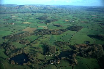
The landscape occupies a relatively flat area on the west side of the Vale of Montgomery, generally between a height of about 120-150m OD. The underlying solid geology is composed of Silurian shales and the soils are fine silty and clayey stagnogleys, subject to some seasonal waterlogging. There are a number of low-lying areas with impeded drainage where natural ponds have formed, some of which have been artificially enlarged. There are a number of managed poplar and conifer plantations in the arrea. Some of the woodland areas, like Dudston Covet, New Covet (Plantation) and Boardyhall Wood have been in existence since at least the mid 19th century.Present-day settlement is limited to Lymore and Pen-y-bryn Hall. The surviving buildings at Lymore include a large 18th/19th-century brick farmhouse, stone and brick walled gardens and various outbuildings including 17th/18th-century timber-framed buildings, 18th/19th-century brick buildings, ?19th-century stone-ended dutch barn and 20th-century steel-framed buildings, and gardener's/gamekeeper's cottages. Included in the area is Pen-y-bryn Hall is a brick-built Georgian country house of about 1800, with courtyard and gardens, on south-facing slopes about 2km further south.
The predominant land-use is pasture and small woodland plantations though some former areas of parkland are now ploughed. Substantial areas of medieval ridge and furrow in Lymore Park, noted above, seem likely to represent part of the medieval open-fields associated with the town of Montgomery, fossilised when the area was emparked, possibly in the 16th century. A modern plant nursery, together with taller trees and shrubs along field boundaries and watercourses and former fish ponds on the stream known as Lack Brook to the south of Pen-y-bryn Hall have the effect of extending the parkland character of the area further to the south. Disused marl pits are recorded in the southern part of the area, probably used in the course of the agricultural improvements which took place during the 18th and 19th centuries.
The area is crossed by a number of footpaths and tracks, some of which represent early medieval and later routeways, parts of which survive as hollow-ways, replaced by more recent turnpike roads. One route appears to have run from the ford across the Severn at Rhydwhiman (see Trehelig-gro character area) to Churchstoke, via Hen Domen. Another cut across the northern end of the character area, marking the line of the former route between Montgomery and Chirbury, via Dudston.
Present-day parkland is represented by scattered mature oaks, planes, chestnuts and beeches, including a partial line of trees alongside the B4385 between Montgomery and Brompton. A comparison between the modern map and Ordnance Survey maps of the late 19th century indicates that the parkland area is now less extensive than it was, particularly on the south, some former parkland areas now being ploughed, though there is some recent planting of parkland trees. Some of the former parkland is subdivided into medium-sized rectilinear and polygonal fields by clipped and formerly laid multiple-species hedges, including hawthorn, oak, holly, hazel and elder. Other divisions are of iron park railings. Part of the parkland is occupied by Montgomery Cricket Club cricket pitch, in an area where part of the ridge and furrow field system has been levelled. 18th-century improvements to the parkland included the creation of a two lakes - Upper Pool and Lower Pool - formed by earthen dams at the springs which feed a stream running northwards, parallel with Offa's Dyke, to meet the Camlad at Caemwgal. A duck decoy was built above the Upper Pool between the late 18th and early 19th centuries. Some of the ponds fringed with willow and alder.
Published sources
Arnold & Reilly 1986Barker & Higham 1982
Cadw 1999
Charles 1938
Davies 1945-6
Haslam 1979
Lloyd 1986
Margary 1973
O'Neil 1942
Owen 1932
Powis 1942
Roscoe 1838
Soil Survey 1983
Sotheby's 1999
Walters & Hunnisett 1995
Waters 1932
Williams 1938
For further information please contact the Clwyd-Powys Archaeological Trust at this address, or link to the Countryside Council for Wales' web site at www.ccw.gov.uk.
Privacy and cookies