Cymraeg / English

|
Bro Trefldwyn Historic Landscape |

|
Character area map |
Historic Landscape Characterisation
Bro Trefaldwyn:
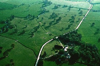
Gunley
Forden, Powys and Chirbury, Shropshire
(HLCA 1064)
Scattered farms, ancient field boundaries, country houses in parkland setting, on sloping ground overlooking northern side of Bro Trefaldwyn.
Historic background
Early settlement is suggested by cropmark enclosure sites of possible Iron Age or Roman date just to the north of Woodlands farm and to the east of Hem Farm. The earliest settlement evidence in the historic period is represented by three settlements listed in the Domesday Book of 1086, Ackley (Achelai), Wropton (Urbetune, an ancient township in the parish of Forden, to the south of Nantcribba), and Hem (Heme). Between them the settlements possessed up to about 600 acres of land (5 hides) of all kinds, with woodland at Hem and hedged enclosures (haia) at both Hem and Ackley of a kind used for capturing deer, presumably driven from woodland on the higher slopes of Long Mountain. Hem in addition possessed three fisheries, presumably along the Camlad, to the south (see Fflôs character area). The place-name Gunley first appears in the 14th century: its origin is obscure, but might derive from a Scandinavian personal name. It may be significant that Hem, lying on the line of Offa's Dyke, is derived from the Old English hem 'border, edge' used by reference to piece of land. A Mercian origin for the defensive works at Nantcribba have been suggested but are as yet unproven.The land attached to the three Domesday settlements, is like many others in the vale of Montgomery described as having been 'waste' at the time of the Norman Conquest and used only for hunting. The area was possibly laid waste in the previous generation during the Welsh attacks on Mercian territory. These three settlements, together with Stockton, on the eastern side of the character area, all lie to the east of the Mercian frontier built before the death of king Offa in 796, and were probably founded or taken over from the Welsh some time between about the late 8th or early 9th centuries. Indeed, it has been suggested that the course of the dyke, jutting forward at this point to include a substantial portion of the lower Camlad valley, is likely to have been set out across a cleared and cultivated landscape in relation to the limits of the actual or agreed contemporary extent of Mercian settlement.
Recovery was evidently being made at the time of Domesday, once the area had come under Norman control. The farming landscape probably continuing to develop throughout the Middle ages despite the continued unrest along the borderland in the 12th and 13th centuries - Ackley, for example, together with Lletty Gyngfach, on the high ground towards the northern side of the character area, being counted amongst the settlements said to be held by Llywelyn ap Gruffudd, Prince of Wales, in about 1270. Nantcribba Gaer, a rectangular stone castle on a high natural rock outcrop was known as Gwyddgrwg castle, and probably built by Thomas Corbet of Caus in about 1260 and destroyed by Gruffydd ap Gwenwynwyn in 1263. It was evidently much better preserved when visited by Thomas Pennant in the 1780s.
Most of the farmland in the character area is likely to have developed to something approaching its present form by the early post-medieval period by the gradual clearance of woodland and piecemeal enclosure. None of the area was subject to enclosure awards during the later 18th or early 19th centuries.
The 17th and 18th centuries saw the rise of the estates, Gunley Hall with its Jacobean and subsequent late Georgian hall in its parkland setting forming the focus of the smaller Montgomeryshire estates which included Ackley and Llettyfynfach. Nantcribba, formerly belonging to the Devereux family and purchased by the Naylor's in 1863, formed part of the Leighton Hall Estate. By the 19th century the western part of the character area fell within the townships of Hem, Wropton, Ackley and Llettygynwyr, in the ecclesiastical parish of Forden, Powys and the eastern part of fell within the townships of Stockton and Wortherton, in parish of Chirbury, Shropshire.
Key historic landscape characteristics
Steep to more gently sloping, south-facing lower slopes on the southern end of Long Mountain, ranging in height from between about 90-225m OD and dominating the lower Camlad valley. Well-drained, fine, loamy and silty soils, on higher ground, with shallow soil profiles on steeper slopes, overlying shalely bedrock. Fine silt-loam-clay stagnogley soils on lower slopes, with occasional seasonal waterlogging. The principal modern land-use is pasture, but there are extensive wooded areas on high ground including the ancient replanted woodland at Gunley Wood, with numerous smaller and residual areas of ancient semi-natural deciduous woodland, predominantly oak, on steeper slopes and stream valleys elsewhere.Present-day settlement is represented by clustered, medium-sized farms, often sited on public roads, some seemingly amalgamated in recent years. Late 18th to late 19th-century brick farmhouses and outbuildings at Woodlands, Parklands, Hem, and Cwm Farm. More uncommon is the substantial, early to mid-18th-century farmhouse at Llwynrhedydd and the possibly 18th-century stone outbuildings, as at Woodlands, Rhyd-y-groes and Llwynrhedydd, some with weatherboarding, ?19th-century brick hay barn at Cwm Farm, and 20th-century steel-framed buildings frequently and slurry tanks or grain silos less frequently added to the earlier farm complexes. Few early timber buildings appear to have survived, but examples include Hen Nantcribba, ?17th century timber-framed house partly rebuilt in stone, and the 17th to possibly early 18th-century timber-framed cottages at Stockton Smithy, with brick infill. Nothing remains of the subsequent late 17th-century to early 18th-century brick hall at Nantcribba, burnt down in about 1900, though the late 18th-century brick-walled garden and late 19th-century yellow brick, single-storey lodge with brick entranceway with stone pillars and copings survive. The adjacent Nantcribba Hall Farm, built in the 1860s as part of the Leighton Hall estate, has a large 19th-century brick farmhouse with sandstone dressings and a range of brick outbuildings which form part of a model farm complex, the effluent from which is said to have flowed away via an underground system to the adjoining fields. Also forming part of the complex were the Victorian Nantcribba Cottages, probably built as farmworkers' cottages. The medium-sized country house at Gunley Hall, where an original Jacobean house was replaced by an early 19th-century stucco-fronted house, enlarged in late 19th century. Associated with Gunley Hall are a converted brick stable block, 18th- to early 19th-century octagonal brick dovecote and brick gazebo or garden pavilion, together with entrance with stone and marble pillars and iron railings.
Irregular small- to medium-sized fields with hedged boundaries characteristically set out along or up and down the contour, with lynchet formation on steeper slopes, suggesting progressive piecemeal woodland clearance and amalgamation of boundaries. Multiple-species hedges, including hawthorn, hazel, field maple, holly and elder, likewise suggest that many of the boundaries are of some antiquity and derive from woodland clearance.
Comparison with the tithe maps and early editions of the Ordnance Survey indicate that the present-day field pattern has changed little since at least the middle of the 19th century.
The main east-west road running across the area B4386 was improved as a turnpike road in the late 18th century but for much of its course overlies the line of the Roman road between Roman fort at The Gaer and Roman Wroxeter. The Roman road is visible as an earthwork just to the east of Gunley Hall.
There are scattered small stone quarries, largely of unknown date, though some are marked as 'Old Quarry' on Ordnance Survey maps of the 1880s, including gravel pits in Gunley Wood and to the east of Ackley Farm. The boss of rock on which the stone castle at Nantcribba Gaer was sited was used as a quarry for repairing roads in the late 18th and early 19th centuries. Stockton Mill, an early 19th-century brick structure, was a former watermill on the Camlad.
Much of the parkland survives at Gunley Hall, though some areas to the south of the Camlad have been lost since the 19th century. Plantings include ash, oak, Scot's pine, Wellingtonia, plane, and cedar, with some subdivision of the parkland pasture by post and wire fencing and iron railings along the public road through park. The parkland overlies and has helped to preseve a significant area of ridge and furrow representing an area of medieval open-field arable in the township of Ackley, emparked in possibly the 17th or 18th century.
Formerly there were a number of notable springs in the area. A roadside spring on the lane to Cwm Farm was said to be a place of pilgrimage for those seeking a cure for weak eyes. Annual gatherings were held at a spring in King's Wood, and there was a petrifying spring in Gunley Wood in which objects were placed.
Published sources
Anon 1892Charles 1938
Eyton 1854-60
Fox 1955
Gelling 1992
Haslam 1979
Hogg & King 1967
Humphreys 1996
King & Spurgeon 1965
Musson & Spurgeon 1988
Pennant 1784
Pryce 1898
Putnam 1969-70
Smith 1999
Soil Survey 1983
Sothern & Drewett 1991
Spurgeon 1961-62
Spurgeon 1981
Thorn & Thorn 1986
Vize 1882; 1883; 1884
For further information please contact the Clwyd-Powys Archaeological Trust at this address, or link to the Countryside Council for Wales' web site at www.ccw.gov.uk.
Privacy and cookies