Cymraeg / English

|
Bro Trefldwyn Historic Landscape |

|
Character area map |
Historic Landscape Characterisation
Bro Trefaldwyn:
Forden
Forden, Powys
(HLCA 1063)
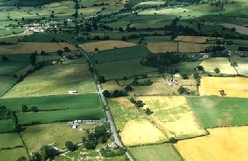
Late 18th- to early 19th-century enclosure landscape, small farms and tenements, set out along turnpike road and straddling Offa's Dyke, superimposed upon possible early medieval and medieval nucleated settlement with medieval chapel.

Historic background
The area falls within the 19th-century ecclesiastical parish of Forden, formerly within the diocese of Hereford but now within the diocese of St Asaph, and was originally a dependent chapelry within the much larger parish belonging to St Michael's Church, Chirbury. The new ecclesiastical parish of Forden was created following the dissolution, when the priory at Chirbury was closed.The parish of Forden sits astride Offa's Dyke, built in the late 8th century. A settlement at Furtune is first recorded in the Domesday Book of 1086, having up to about 60 acres (1/2 hide). It appears to have been one of a number of townships in Bro Trefaldwyn which have their origin as Mercian settlements, probably established after the construction of Offa's Dyke, in the 9th and 10th centuries, abandoned in the 1040s, before the Norman Conquest, but which had recovered by 1086. The name of the settlement derives from Old English ford 'ford' and tun 'settlement', presumably by reference either to the ancient ford across the Severn at Rhydwhiman at the southernmost tip of the ecclesiatical parish or alternatively the fording point on the western side of the parish between Dyffryn and Lower Munlyn. A chapel at Forden had probably been founded by about the beginning of the 14th century, but is not mentioned in the ecclesiastical taxation of 1291.
Considerable changes to the landscape were made to the character area at the end of the 18th century and during the course of the 19th century, following the construction of the Montgomery-Welshpool turnpike road (B4388/A490) across the area in the late 18th century. A large proportion of the area subject to enclosure awards 1803 had formerly been unenclosed 'wild heath or common' stretching from The Gaer along the road to Cilcewydd, Upper Munlyn, for example, being described as being 'in an open, wild place'. With enclosure came a proliferation of 'huts erected suddenly, so as to give their builders an invested right to them', though by the later 19th century the area was already suffering from depopulation as the children of farmers and labourers were heading for the larger towns.
The imposing redbrick Pool-Montgomery Union 'House of Industry' (the former Bryn Hyfryd Hospitable) which dominates the southern end of the character area was built in 1793-95 by nine parishes and six townships in the neighbouring border country of Montgomeryshire and Shropshire with the intention of relieving the heavy burden of ministering the poor. The old medieval church was pulled down and replaced slightly to the north by a new church dedicated to St Michael in 1867. Until 1818 those that died in the workhouse were buried at the church, but due to the enormous number of deaths that occurred there at that time and the high burden this imposed on the parish a new graveyard with unmarked graves was consecrated next to the workhouse, which was further extended in 1881. At its height, in 1817, up to 500 of Montgomeryshire's rural poor were in residence at the workhouse. With a motto reading 'Religion and Industry, Produce and Happiness' it was equipped for a wide variety of trades, including flannel and linen looms, workshops for clothing and shoe manufacture, a farm and a corn mill (Gaer Mill, Penylan character area).
Key historic landscape characteristics
Flattish and gently undulating landscape between a height of between about 80-150m above Ordnance Datum. The underlying geology is composed of Silurian shales, overlain by boulder clay with rounded pebbles. Soils are fine silty and clayey stagnogleys, subject to some seasonal waterlogging.Little evidence is forthcoming about the form of settlements that probably developed in the early medieval and medieval periods, and possibly around the medieval church. Two distinct focal points had formed by the earlier 19th-century at least, one around the church and the other around Cock Inn, where the road branches off northwards towards Leighton. The complex around the Victorian church includes a brick school of 1842, Victorian brick vicarage, late 18th/early 19th-century brick cottages with traces of 18th-century timber-framing, with modern houses and bungalows, modern community hall, playing fields. The complex around the Cock Inn comprises the large late 18th-century roadside brick inn, 18th/19th-century stone and brick cottages, large two-storey brick hay barn, late 19th-century stone chapel with brick dressings and corrugated-iron hall and two modern garages, and occasional earlier buildings, including a 16th-century timber-framed cottage. Actively expanding modern residential developments at Kingswood, further to the north. In the countryside between and around these two centres are small scattered farms and smallholdings, generally within 400-500m of each other, often with late 19th/20th-century brick farmhouses, as at Church Farm and Farchwel Newydd, but with occasional remnants of 18th-century timber-framing. Small 19th/20th-century weatherboarded and brick outbuildings, small steel-framed dutch barns and Nissen huts, and occasional larger modern steel-framed outbuildings.
Relatively small rectangular hedged fields, predominantly single-species hawthorn, with some former hedge-laying, generally low cut, with some post and wire fence subdivisions, largely set out in relation to the late 18th-century turnpike roads. Taller willows along water courses. The field pattern shown on the mid 19th-century tithe map survives though some field boundaries have been lost.
Published sources
Barton 1999Ellis 1935
Fox 1955
Haslam 1979
Humphreys 1996
Pryce 1898
Soil Survey 1983
Thorn & Thorn 1986
Vize 1882a; 1882b; 1883; 1884
For further information please contact the Clwyd-Powys Archaeological Trust at this address, or link to the Countryside Council for Wales' web site at www.ccw.gov.uk.
Privacy and cookies