Cymraeg / English

|
Caersws Basin Historic Landscape |

|
Character area map |
|
|
More photographs |
Historic Landscape Characterisation
The Caersws Basin:
Caersws
Caersws, Llandinam, Aberhafesp and Mochdre communities, Powys
(HLCA 1182)
Modern village, originating as a medieval borough, overlying a Roman civilian settlement alongside a Roman fort, which owes its development initially to its position on the road and rail networks of the later 18th and 19th centuries and latterly as a dormitory village for Newtown.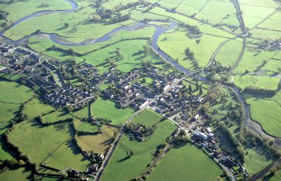
Historic background
The area formed parts of the manorial township of Caersws in the tithe parish of Llanwnog.Key historic landscape characteristics
Lowlying and relatively flat valley bottom mostly just above the floodplain of the river Severn, at a height of 120-130 metres. Flood defences along the Garno and Severn appear to have been built partly in the later 19th century in conjunction with the construction of the railways and partly during the 20th century.A number of small lowland commons in and around the village Caersws were the subject of parliamentary enclosure in the early 19th century.
The Roman fort, whose defences still survive as earthworks just to the north of the modern village centre, was built in the angle between the Severn and Garno in the later 1st century, following the conquest period. The fort included a complex of both stone and timber buildings and was defended by stone walls and gate towers. It lay at the hub of a Roman road network connecting to the fortress and town of Wroxeter to the east, probably to a fort in the Bala area to the north, probably with the fortlet at Penycrocbren and the fort at Pennal to the west, and with the fort at Castell Collen near Llandrindod Wells to the south. A civilian settlement grew up over an area of at least 8 hectares on the southern and eastern sides of the Roman fort, much of it now below the modern village. It was formed of timber buildings set out on a grid of streets and lanes, which housed merchants and artisans supplying goods and services to the Roman army. The industries which were carried out here included kilns manufacturing floor tiles based upon local clay deposits, as well as ironworking and bronze casting. A bathhouse was built just to the south-west of the fort which was probably fed by water taken by a leat from the river Garno. There are suggestions that a Roman cemetery may also have been established in this area. Occupation of both the fort and associated civilian settlement appear to have rapidly declined in the first half of the 2nd century AD though there are indications that the fort at Caersws may have been maintained as an administrative centre until at least the 3rd or 4th century.
In the post-Roman period the administrative focus of the area appear to have shifted to the nucleated church settlements at Llandinam to the south of the Severn and Llanwnog to the north. It appears that attempts were made by the lords of Arwystli or Powys to establish a borough with weekly markets at Caersws, lying between those which were created further upstream at Llanidloes and further downstream at Newtown. This was evidently unsuccessful, and by the 16th century it was no more than a small hamlet. The name Caersws, first recorded in the 1470s, is thought to combine caer, a reference to the Roman fort, and a personal name, possibly Swys.
Areas of lowland common in and around the village of Caersws and the lower Manthrig Brook survived until the early 19th century when they were the subject of the Arwystli enclosure act.
The main period of development of Caersws came with the improvements to the turnpike roads in the later 18th and earlier 19th centuries and it consequently has the character of a roadside village developed at an important river crossing and road junction. Although there is at least one traditional vernacular building in the village, its character is in many respects much more urban and industrial than rural (albeit on a very small scale). This development includes a series of terraces, one of which is 3-storeyed, probably early C19 and is reminiscent of the rows associated with the woollen industry in Penygloddfa, Newtown. Much of the rest clearly post-dates the railway.
Several inns were built to serve travellers passing through the village and the village also includes the stone-faced, mid 19th-century house of Dolaethnen associated with the Williams Wynn estate. The Caersws Workhouse was built on the eastern side of the village in the 1830s to house up to 350 paupers, being partly built of bricks from local clay dug and fired in kilns to the north-east of the village centre. It subsequently became Llys Maldwyn Hospital and has recently been converted to alternative uses. The village further expanded with the coming of the railways in the 1860s and 1870s, when Caersws was provided with a single storey station with attached two-storey stationmaster’s house and a detached signal box. Caersws was also the mainline junction for the Van Railway, the mineral line serving the lead mines north of Llanidloes, for which an office and engine shed were provided on the west side of the village. The engine shed of yellow brick with cast-iron windows survives, as does a much altered small red brick station building which stands on the original platform. Workers housing and shops were built in Caersws, as well as a church and two nonconformist chapels during the 19th century which together with other buildings display a particularly good variety of brick types and colours, including a distinctive yellow brick. During the 20th century there has been some infill housing in the village core, but the most marked expansion has been the housing estates and school to the east of the village centre, across the Manthrig Brook. The diversity of building, building functions and building materials all make important contributions to the distinctive character of the village core at Caersws.
Sources
Historic Environment Record; Cadw Listed Building descriptions; modern Ordnance Survey 1:10,000, 1:25,000 mapping and 1st edn Ordnance Survey 1:2,500 mapping; Anthony 1995; Baughan 1980; Bosanquet 1909; Britnell 1989; Burnham 1995; Colt Hoare 1806; Cozens 1953; Cozens et al. 2004; Daniels, Jones and Putnam 1966, 1968, 1970; Davies 1829; Davies 1943-44, 1945-46; Davies 1943-44, 1945-46; Davies 1943-44, 1945-46; Davies and Jones 2006; Hankinson and Jones 2003; Haslam 1979; Howell 1875; Jarrett 1969; Jarrett 1994; Jones 1961; Jones 1983; Jones 1985; Jones 1987; Jones 1993; Lewis 1833; Morgan 2001; Owen 1990; Owen 1993; Pennant 1783; Pritchard 1962; Pryce 1940; Pryce 1931; Putnam 1961-62; Rivet and Smith 1979; Silvester 1992; Soulsby 1983; Stephens 1986; Thomas 1955-56For further information please contact the Clwyd-Powys Archaeological Trust at this address, or link to the Countryside Council for Wales' web site at www.ccw.gov.uk.
Privacy and cookies