Cymraeg / English

|
Tanat Valley Historic Landscape |

|
Character area map |
Historic Landscape Characterisation
The Tanat Valley:
Mynydd Mawr, Llanrhaeadr-ym-mochnant, Powys
(HLCA 1018)
Early post-medieval to 18th/19th-century piecemeal enclosure of isolated upland area on southern edge of the Berwyns.

Historic background
The area fell within the parish of Llanarmon-mynydd-mawr, which during the medieval period was a chapelry within the parish of Llanrhaeadr-ym-mochnant, falling with the commote of Mochnant Is Rhaeadr.
Key historic landscape characteristics
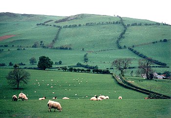
Upland area on southern edge of the Berwyns with predominantly south-facing slopes, ranging in height from between about 330-530m OD, with small rocky outcrops and screes.
The more sheltered, south-facing slopes on the eastern side of the character area are predominantly improved grassland, the steeper and more exposed western slopes being rough grazing with bracken and gorse. Large irregular fields probably representing piecemeal enclosure of upland common from the early post-medieval period to the 18th/19th century. Mixture of boundary types including grown out hedges with spaced trees and shrubs, stony clearance banks, dilapidated drystone walling, and post and wire fencing.
For further information please contact the Clwyd-Powys Archaeological Trust at this address, or link to the Countryside Council for Wales' web site at www.ccw.gov.uk.
Privacy and cookies