Cymraeg / English

|
Tanat Valley Historic Landscape |

|
Character area map |
Historic Landscape Characterisation
Dyffryn Tanat / The Tanat Valley:
Glantanat, Llanrhaeadr-ym-mochnant and Llangedwyn, Powys
(HLCA 1003)
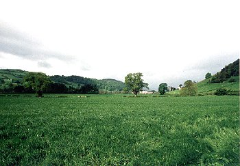
Large rectangular fields with hedged boundaries on valley bottom in eastern area of Dyffryn Tanat

Historic background
The character area falls largely within the medieval ecclesiastical parish of Llanrhaeadr-ym-mochnant and partly in the parish of Llangedwyn, and administratively within the ancient commote of Mochnant Is Rhaeadr, Denbighshire. A thin slip of land to the west of Glantanat-uchaf fell within the Montgomeryshire portion of the Llanrhaeadr-ym-mochnant parish.
Probable late Neolithic and early Bronze Age activity in the character area is represented by at least two linear settings of up to five or six ring-ditches of ploughed-out burial mounds, recorded as cropmarks by aerial photography. The broader context of the monuments is uncertain, but it can be assumed that at least some clearance of woodland had already taken place by this date. Indeed, the linear settings of ring-ditches may indicate that they were set out along pre-existing boundaries or along the edges of fields.
Key historic landscape characteristics
Flat valley-bottom land, alongside the Afon Tanat, between about 105-120m OD, with slight river terraces in places towards the margins of the area. Confluences with the Afon Rhaeadr and Afon Iwrch fall within the western end of the character area. The land lies on gravels and alluvium and is generally well drained, though old river meanders are represented by fairly extensive areas of waterlogging and standing water alongside the river as well as by dry palaeochannels represented by undulations in the surface. The meadow land continues further to the east but has been included within the Llangedwyn character area because of its visual importance to that landscape.
Settlement is confined to a number of scattered, large and well-established farms of probable late medieval or early post-medieval origin on narrow strip of flatter ground to the south of the river, often 1km or more apart, together with a number of post-medieval farms and houses along the turnpike road between Llangedwyn and Llanrhaeadr, including a row of 18th-century stone cottages with brick dressings and slate roofs at Pentrefelin. The older farms include Gartheryr, the two large farmhouses at Glantanat-uchaf and Glantanat-isaf, which are of mid 17th-century date, and Henblas where a late medieval cruck-built barn probably represents the earlier house, replaced a brick farmhouse in the 18th century. 17th/18th-century stone outbuildings at Glantanat-isaf, stone-walled yard and some stone outbuildings at Glantanat-uchaf. Rendered ?18th-century stone farmhouse at Banhadla with 18th/19th-century stone outbuildings, some with weatherboarding, 18th-century stone farmhouse and outbuildings, some again with weatherboarding, at Bont Glantanat Farm.
The predominant land-use is as pasture and meadow. Large, rectangular and irregular pasture fields, generally with low clipped hedges and occasionally subdivided by post and wire fences. The boundaries are generally single species hedges, invariably hawthorn, and often supplemented by post and wire stock-proof fencing, with occasional laid hedges on roadsides. Scattered mature oaks in hedgerows and taller alders and ashes along the river edge and along streams and watercourses. Occasional stone gateposts on field gates on public roads. A majority of the field boundaries appear to be set out in relation to the turnpike road between Llangedwyn and Llanrhaeadr, and it therefore seems likely that they represent 18th-century enclosure of formerly unenclosed meadow in a number of townships bordering the river.
The main road between Llangedwyn and Llanrhaeadr is a turnpike road built in the later 18th century and probably replacing a route which ran across higher ground to the north. The principal crossings of the Afon Tanat, by means of the stone bridges at Pont Glantanat-uchaf at the western end of the character area and Pont Llangedwyn at the eastern end, together with Pont Pentrefelin across the Lleiriog and Pont Maesmochnant across the Afon Iwrch, are also of this date.
The course of the former, early 20th-century Tanat Valley Light Railway is still visible as either an embankment or cutting, running at an angle across the earlier field pattern. There was originally a railway bridge across the Afon Tanat, just to the east of Gartheryr. The platform and sidings at the former station at Pentrefelin are still visible.
Sources
Hubbard 1986Wren 1968
For further information please contact the Clwyd-Powys Archaeological Trust at this address, or link to the Countryside Council for Wales' web site at www.ccw.gov.uk.
Privacy and cookies