Cymraeg / English

|
Bro Trefldwyn Historic Landscape |

|
Character area map |
Historic Landscape Characterisation
Bro Trefaldwyn:
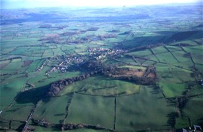
Ffridd Faldwyn
Montgomery, Llandyssil and Churchstoke, Powys
(HLCA 1079)
Hill-land on the western side of the vale of Montgomery, with prehistoric hillfort and smaller defended settlements, ancient routeways, scattered farms, residual areas of natural woodland, and enclosed upland common.
Historic background
The area falls within the following ecclesiastical parishes of Montgomery, Llandyssil, Churchstoke (Weston Madoc township), and Kerry (Caeliber Issa township). Little is known about the history of land enclosure in the landscape area as a whole. The majority of the land is shown as being enclosed by the time of the tithe apportionments, in the first half of the 19th century, though some the more rectilinear fields on the edge of the hill to the south-east of Little Pentre Farm, on the western edge of Churchstoke parish, and on the hill edge land of Caeliber Isaf, between Drainllwynellyn farm and Perthybu farm, in the parish of Kerry were subject to enclosure awards in 1803 and 1805.The earliest settlement in the area is represented by fragments of Neolithic pottery, flintwork and a polished flint axe found during in pits pre-dating the hillfort at Ffridd Faldwyn during the course of archaeological excavations in the late 1930s. The first fortification of on the hill appears to have been a timber palisaded settlement which though undated may belong to the later Bronze Age. This was in turn superseded by a univallate and subsequently by a multivallate enclosure, probably of the middle to later Iron Age, with heavily defended entrances and an interior crammed with timber structures including rows of four- and six-post timber buildings possibly representing storage buildings, which had probably been abandoned before or at about the time of the Roman conquest. Other smaller defended enclosures occupy a number of hill-tops and hill-slopes in the area, including two cropmark sites to the north of Jamesford and an earthwork enclosure near Butcher's Wood which are likely to have been occupied in the Iron Age and possibly Roman and possibly later periods. A royal windmill, dating to the 1220s and 1230s appears to have been built in the area, somewhere to the west of Montgomery, though its precise location is unknown.
Ffridd Faldwyn hillfort was probably used as the siege camp by the Royalists during the siege of Montgomery Castle between 7-8 September 1644, a large amount of lead shot having been found in the fields between the hillfort and Montgomery Castle.
Key historic landscape characteristics
North-south upland ridge of Silurian shales or varying hardness and softness, between a height of between about 130-320m above Ordnance Datum, sloping more gently on the west where it overlooks the Severn valley and more steeply on the east where it overlooks the vale of Montgomery. Generally well-drained, fine loamy and silty soils, shallow on more steeply sloping ground, with rock exposures on the steepest prominences, sometimes with gorse and bracken. Areas of ancient semi-natural deciduous woodland survive on the eastern slopes of Ffridd Faldwyn and on a number of steeper slopes elsewhere, such as Pant-y-maen wood. There are also a number of areas of replanted conifer plantation at Butcher's Nursery south of Montgomery and elsewhere, again on the steeper slopes. A number of place-names in the southern part of the area include elements indicating woodland or scrub vegetation, such as Welsh perthi 'bushes' (Perthybu) and llwyn 'grove' (Drainllwynellyn).Medium- to large-sized scattered farms, characteristically sited on the spring line, with some abandoned farm buildings, as in the case of the hill-top stone and brick complex at Pant-y-maen. The antiquity of these farms on the hill-land above Montgomery is uncertain, though some seem likely to be associated with relatively late resettlement of the hill-land following enclosure of upland commons belonging to Montgomery, Llandyssil, Churchstoke and Kerry. ?19th-century brick farmhouse and outbuildings at Rhiew Goch, Jamesford and Little Pentre Farm, with timber outbuildings at Rhiew Goch and 20th-century steel-framed outbuildings at Jamesford and Little Pentre.
The predominant modern land-use is as pasture. A majority of fields are small to medium in size often with curving upper boundaries running along the contour with woodland above, indicating piecemeal and progressive woodland clearance extending uphill from the lower ground, possibly from the medieval period onwards, though in view of the evidence of prehistoric settlement it is not inconceivable that some of the boundaries have their origins in the prehistoric period. Multiple-species hedges in these areas, including ash, hawthorn and hazel, oak and holly, some laid or low cut and some overgrown or intermittent, often associated with low banks and lynchets, some of substantial size, on more steeply-sloping ground. Some fields have been amalgamated into one, former boundaries being represented by low old field banks, but comparison with the tithe and early editions of the Ordnance Survey indicates that the present-day field pattern here has changed little since the middle of the 19th century, though some former hedges have now been replaced by post and wire fencing. Relatively recent enclosure of cleared land is suggested by areas of planned field patterns with rectilinear boundaries on the hill just to the south of Ffridd Faldwyn and the west of Montgomery, and in the Caeliber Isaf area towards the southern end of the area. The former seems likely to represent enclosure of the upland common once belonging to the parish of Montgomery, its name being derived from the Welsh ffridd 'woodland, or mountain pasture' (from English frith) and faldwyn from the Welsh name for Montgomery. As noted above, the areas with more regular field boundaries towards the southern part of the area represent late 18th- and early 19th-enclosure of upland common in the parishes of Kerry and Churchstoke. Field boundaries in the latter areas are generally mixed species, however, including hawthorn, wild cherry, hazel and ash, some low cut, some overgrown, some formerly laid and some grown out and being replaced with post and wire fences.
There is a network of twisting lanes, green lanes and footpaths, some of which are likely to be of considerable antiquity, including possibly an ancient route linking Ffridd Faldwyn hillfort and the upland area beyond with the historic ford at Rhydwhiman (see Trehelig-gro character area), routes giving access to the ffridd from the town of Montgomery, and the hill road to Llandyssil. Some hollow-ways are up to 3-4m deep and clearly of considerable antiquity.
There are numerous small, old, scattered stone quarries of uncertain date, though many are shown as either 'Quarry' or 'Old Quarry' on Ordnance Survey maps of the 1880s.
The war memorial on the highest point of the hill forms a distinctive Montgomeryshire landmark.
Published sources
Arnold 1987Barker & Higham 1982
Barton 1997
Guilbert 1975; 1981
Hogg 1975
Musson 1991
O'Neil 1942
Savory 1976
Soil Survey 1983
Sothern & Drewett 1991
Stanford 1974; 1980
Walters & Hunnisett 1995
For further information please contact the Clwyd-Powys Archaeological Trust at this address, or link to the Countryside Council for Wales' web site at www.ccw.gov.uk.
Privacy and cookies