Cymraeg / English

|
Bro Trefldwyn Historic Landscape |

|
Character area map |
Historic Landscape Characterisation
Bro Trefaldwyn:
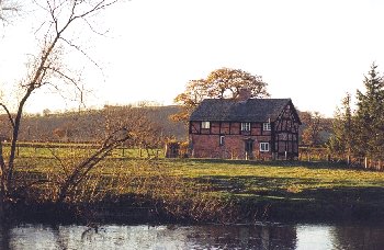
Trehelig-gro
Berriew and Forden, Powys
(HLCA 1062)
River Severn and floodplain landscape with river cliffs, small beaches, river meanders, oxbow lakes and palaeochannels, historic fords and ferries, bordered by large flat irregular fields representing late enclosure of common meadowland.
Historic background
The area forms parts of the ecclesiastical parishes of Forden, Berriew and Montgomery. Early settlement is suggested by a cropmark ring-ditch to the north of Lower Munlyn, possibly representing a Bronze Age round barrow, though little other evidence of early prehistoric activity is known from the area.The upper reaches of the Severn between Welshpool and Newtown is normally insufficiently deep to still be navigable yet is sufficiently formidable to have acted as a barrier rather than a routeway into mid Wales until the early post-medieval period when bridges were built at Cilcewydd at the northern end of the area and Caerhowel just to the south. For a period it became a linguistic boundary - the life of St Beuno of Berriew, whose early years, in the late sixth and early 7th century, was spent at Berriew, notes that he was so shocked at hearing 'Saxon' spoken on the opposite bank of the river that he left for north Wales. It became a political boundary at various periods during the early historic periods, and a meeting ground between the two nations, being the spot where the treaty of Montgomery was concluded between Llywelyn ap Gruffudd and Henry III in 1267, conferring the status of Prince of Wales upon Llywelyn. For a time it became the boundary between Welsh and English dioceses, Bishop Swinfield of Hereford in 1288 declaring the river between the ford at Rhydwhiman and the ford at Shrawardine to the west of Shrewsbury to be the boundary between the dioceses of Hereford and St Asaph. Fords became the important and symbolic meeting grounds between the political entities to either side of the river by at least the 12th and 13th centuries, of which at least two fell along this stretch of the river. The first, Rhydwhiman - the ford of Montgomery - became the most important of these early meeting places in the central borderland, the earliest reference to it perhaps being Horseforde in the Domesday Book of 1086, its Welsh name being derived from rhyd chwima meaning 'swift ford'. It became the meeting ground of Welsh princes and English kings in the early historic period, a status is maintained until the Edwardian conquest of Wales in the 1270s. It was here that the Treaty of Montgomery between Llywelyn ap Gruffudd and Henry III was concluded in 1267, conferring the status of Prince of Wales upon Llywelyn.The second was at Dyffryn, on Carreg Beuno lane. By the 12th century both fords had become defended on the English side, by Hen Domen in the case of Rhydwhiman and by Lower Munlyn motte in the case of the Dyffryn ford. A ferry is shown on early Ordnance Survey maps between Trehelig-gro and Cilcewydd.
Most of the agricultural land in the character area appears to have been enclosed by the late 18th and early 19th centuries, though some of the riverside meadow land to the north of The Gaer, in the township of Thornbury, was subject to enclosure awards in 1803. Changes in the course of the river are evident near the confluence of the Camlad and the Severn, where part of the parish of Berriew lies on the eastern side of the river along the line of oxbow lakes marking the former course of the Severn.
Key historic landscape characteristics
Flat floodplain of the Severn and its confluence with the river Camlad, between 70-95m OD. Well-drained, deep, stonefree, brown alluvial silty soils, with gravelly subsoil in places, liable to flooding. The riverside landscape includes low river cliffs, small gravel beaches and islands, river meanders, and oxbow lakes and palaeochannels of potential palaeoenvironmental importance. The present-day land-use is predominantly pasture and meadow, with some fodder crops. Reed beds in oxbows, and hazel scrub vegetation and taller sycamores, oaks, poplars, willows, alders and ash and small areas of deciduous woodland on steeper terraces on edge of floodplain. Part of the area forms the Dolydd Hafren wetland nature reserve, and as a whole it is virtually devoid of modern settlement which is largely restricted to a small number of farms on ground slightly elevated above the floodplain.Large irregular fields with curving boundaries defined by the river and old river terraces, with generally low-cut multi-species hedges including willow, oak and hazel, and some larger fields subdivided by straight, post and wire fencing. Extensive flood bank system of uncertain date on the west side of the river near Trehelig-gro, (again shown on Ordnance Survey maps of the 1880s). One of the few structures recorded in the area is a sheepfold on the opposite site of the river to Trehelig-gro, shown on the 1st edition of the 6-in Ordnance Survey. Most of the field boundaries in the character area are likely to represent late medieval or post-medieval enclosure of former commons and wastes belonging to the townships on either bank of the river, those in the parish of Berriew frequently going by names such as Gro 'gravel' and Llyndir, possibly llyng-dir 'swampy ground'. Comparison with tithe maps and early editions of the Ordnance Survey indicate that the present-day field pattern had become established by at least the mid 19th century, though a reasonable number of field boundaries have evidently disappeared since the 1880s. Trackways and footpaths, some probably of considerable antiquity, give access to the former fords, ferries and commons.
Fishing must always have been an important activity along the riverbank, the fishing rights being privately owned at the present day. The stretch of the Severn next to the Gaer was formerly known as Llyn y glisied 'salmon pool'.
Published sources
Anon 1888aAnthony 1995
Bowen 1930
Davies 1999
Gibson 1995
O'Neil 1942
Jenkinson 1997
Jones & Jones 1949
King & Spurgeon 1965
Smith & Evans 1995
Soil Survey 1983
Spurgeon 1965-66
Thorn & Thorn 1986
Vize 1882
For further information please contact the Clwyd-Powys Archaeological Trust at this address, or link to the Countryside Council for Wales' web site at www.ccw.gov.uk.
Privacy and cookies