Cymraeg / English

|
The Middle Wye Historic Landscape |

|
Character area map |
Historic Landscape Characterisation
The Middle Wye:
Gwy
Bronllys, Glasbury and Gwernyfed, Powys
(HLCA 1098)
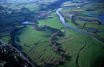
Floodplain of the Wye with oxbow lakes and river meanders and field boundaries representing late enclosure of former low-lying common meadows between Glasbury and Hay.
Historic background
Prehistoric burial and ritual activity is represented by cropmark ring ditches on the edge of the floodplain near Applebury to the north of the Wye and at Spread Eagle to the south, and by a probable Neolithic cursus monument at Spread Eagle. The probable site of the pre-conquest medieval clas or mother church of Glasbury is still to be seen at the confluence of the Wye and Llynfi rivers, abandoned following a change in the course of the river in about 1660 and replaced by a church on the present site of St Peter's Church. The church was refounded in about 1090, its incomes being gifted to St Peter's, Gloucester. The church was originally the focus of the extensive ecclesiastical parish of Glasbury which extended from southern Radnorshire to the foothills of the Black Mountains. In the middle of the 19th century the area formed part of the medieval ecclesiastical parishes of Aberllynfi, Boughrood, and Glasbury. The character area is named after the Welsh name for the Wye, first recorded by the historian Nennius in the 8th century. The river name may be derived from the element wy ('water'), or may alternative be a simple form of the adjective gwyr ('curving, bending'), describing a meandering river.
Key historic landscape characteristics
Broad, flat and low-lying floodplain of the Wye, to the west of Glasbury, between a height of between 80m and 90m above Ordnance Datum. Soils are predominantly a combination of deep permeable alluvial soil, overlying gravel in places (Teme Series), and well-drained fine loamy soils, overlying gravel in places and in places affected by groundwater in hollows (Rheidol Series). Present-day land-use is as pasture.
The only modern habitations within the area are the isolated low-lying farm complexs at Glasbury Farm and at Y Dderw, just to the east of Llyswen. Y Dderw was originally a large gentry house of the later 16th century with former carriage house and stables, all in stone rubble, the house being rendered and with a stone tile roof, with later 17th century stone rubble corn-barn, converted in the 19th century when the complex became the home farm for Boughrood Castle. Two mounds near Y Dderw, of which one survives, might be 16th- to 17th-century garden viewing platforms.
The landscape is parcelled into medium to large-sized rectangular fields with hedged and fenced boundaries, some laid out with regard to old river channels, and probably representing early post-medieval enclosure of former common meadow land along the floodplain of the Wye. Enclosed orchards near Y Dderw, Applebury Farm, Grange Farm and Pipton on the margins of the floodplain were recorded in the mid 19th century. Elements of transport history within the character area include the late 18th-century sandstone pillar milestones near Little Eames and near Y Dderw on the road between Pipton and Llyswen, and just to the north of Marish on the road between Bronllys and Llyswen, belonging to the turnpike era of road transport, and the embankment of the dismantled late 19th-century Mid Wales Railway, cutting across the floodplain between Little Eames and Boughrood, which ceased operation in the 1960s.
Oxbow lakes and palaeochannels mark the former course of the Wye and potentially preserve deposits which are important to an understanding of the history of vegetation and land-use change in the Middle Wye Valley since the last glaciation.
Sources
Briggs 1991;
Gibson 1999;
Jenkinson 1997;
Jones & Smith 1964;
Powys Sites and Monuments Record;
Soil Survey 1983;
Williams 1965
For further information please contact the Clwyd-Powys Archaeological Trust at this address, or link to the Countryside Council for Wales' web site at www.ccw.gov.uk.
Privacy and cookies