Cymraeg / English

|
The Middle Wye Historic Landscape |

|
Character area map |
Historic Landscape Characterisation
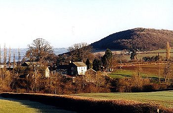
The Middle Wye:
Gwrlodde
Talgarth, Powys
(HLCA 1094)
Dispersed farmsteads and small orderly fields resulting from the systematic woodland clearance and enclosure on the sloping foothills of the Black Mountains south of Talgarth during the medieval period.
Historic background
Early settlement and activity in the area is indicated by the Neolithic long cairn at Penyrwrlodd (Talgarth) and by surface finds of Neolithic and Bronze Age flintwork in the Genffordd area. Later prehistoric settlement is indicated by the Pendre Iron Age hillfort. Nothing is known of early medieval or medieval activity in the area prior to the conquest, and it is possible that it was still largely wooded at this date. Following the Norman conquest the area fell within the sub-lordship of Talgarth. The two farms of Upper and Lower Trewalkin which formed a township near the centre of the character area, have their origin in the period of the Norman conquest. They are named after Walkelin Visdelon whose father, Humphrey, accompanied Bernard de Neufmarché in his conquest of Brycheiniog and who appears to have been granted the manor and probably the motte at Garn-y-castell, sited on spur just below Mynydd Troed. The castle itself is possibly to be identified as 'Waynard's Castle', referred to in an early 12th-century source. The manor was subsequently forfeited and granted to the Benedictine monks of Brecon Priory, disputes arising from their attempts to assart land probably between Trewalkin and Whitelow Farm and Garn-y-castell, at the foot of Mynydd Troed. By the 14th century Genffordd had become an English subtenancy and Garn-y-castell a Welsh freehold tenancy within the lordship. With the exception of several fields which lay within Llangorse, the remainder of the area fell within the tithe parish of Talgarth by the mid 19th century.
Key historic landscape characteristics
The area occupies the lower hill land on the northern edge of the Black Mountains, between Mynydd Troed and Talgarth, broken by the steep-sided wooded fast-flowing stream valleys and waterfalls, including those of the Ennig and Nant yr Eiddil. The area is predominantly north-facing and lies at a height of between 125-370m above Ordnance Datum. The area generally has well-drained fine loamy reddish soils (Milford Series) which overlie sandstone bedrock. The present-day land-use is almost exclusively pasture, which is becoming encroached upon bracken and scrub vegetation in some more marginal areas.
The present day settlement pattern is characterized by small to medium-sized roadside farms, often in close-set clusters, 700-800m apart. The earliest surviving building horizon, possibly of later 16th-century date and contemporary with the pattern of enclosure within the historic landscape character area, is represented by farmhouses of longhouse derivation characteristically set on platforms built up and down the slope, as at Whole House Farm, Upper Trewalkin and Lower Genffordd. The farmhouse at Middle Genffordd, substantially altered in the later 18th or earlier 19th century, retains raised or upper crucks, and reused crucks survive in the roof of a barn at Gwrlodde. The older, possibly later 16th-century farmhouse at The Rhos apparently having stone ground-floor and a timber-framed first floor. A possibly earlier, medieval building horizon may be represented by platform sites, of which a number are recorded in the area between Penisha Rhos and Blaenau-isaf. Complexes of 17th to early 19th-century stone farmhouses and outbuildings, often set out around a farmyard, are represented at Gwrlodde, The Rhos, Troed-yr-harn, Cwm, Rhyd-y-pont, often including barns with cart doors and ventilation slits, and with pigeon lofts in the gable wall of a barn at Pentwyn and under the eaves of the farmhouse at Pendre. A possible former 17th to early 18th-century bakehouse survives at Gwrlodde. The later, early 19th-century brick farmhouse at The Rhos, is relatively unusual in the area. The predominant roofing material is slate, though many of the barn roofs have now been replaced in corrugated iron. Some of the more marginal farms have been abandoned since the later 19th-century due to the amalgamation of holdings, leaving derelict or ruinous farmhouses and outbuildings, as at Blaenau-isaf, though in some instances, as at Blaenau-uchaf the farm buildings continue to be used. A scattering of small ruined cottages and farmhouses in a number of areas points to the abandonment and amalgamation of a number of smaller holdings in more marginal areas during the course of the 19th century.
The area has a distinctive enclosed landscape of small rectilinear fields representing systematic and progressive assarting and enclosure from the medieval period. Field boundaries are generally formed of robust, low-cut multi-species hedges including ash, hazel, oak, and holly. In some areas the clearance and enclosure of farmland had probably already reached the margins of the mountain land by the middle of the 13th century. This is suggested by records which suggest that during the first few decades of the 13th century the monks of Brecon Priory were extending the land they held at Trewalkin by clearing woodland in the direction of Mynydd Troed, at heights of between about 300-400m above Ordnance Datum. Some hedge-laying is still undertaken on lower-lying ground, though frequently derelict or grown out hedges being replaced by post and wire fences on higher ground. Some of the later enclosed fields on higher ground have single-species hawthorn hedges set on low or moderately-sized clearance banks and probably represent 18th- and 19th-century enclosure of former areas of upland grazing. Some lynchet formation on steeper ground represents former more extensive cultivation, former field boundaries occasionally being represented by low banks. There are several sheepfolds on the edge of the common near Pen-y-bryn, some of which are first recorded on the early editions of Ordnance Survey maps published in the later 19th century. An animal pound is shown on the mid 19th-century Tithe Map at Penygenffordd. Many of the farms such as Trewalkin, Whole House, Whitelow, Genffordd, Gwrlodde, Pendre, and Pentwyn, were accompanied by orchards in the 19th century, of which traces survive in some instances.
The area is crossed by a regular network of small lanes and green-lanes, contemporary with the pattern of enclosure link the farms throughout the area, running in hollow-ways, some up to 5m or more deep and evidently of considerable antiquity. The medieval road south of Talgarth via Genffordd has been superseded by the present-day main road to Crickhowell, an engineered turnpike road of the later 18th or early 19th century, which cuts across the pattern of earlier field boundaries. Small modern concrete road bridges have replaced many of the former fords across streams in the area, though several stone slab bridges survive, as for example near the entrance to Blaenau-isaf.
Extractive industry is represented by small scattered sandstone quarries for building stone, probably mostly dating from the 17th century onwards when the use of stone was beginning to replace timber as a building material, together with a number of limestone quarries probably for the production of lime. No surviving limekilns have been identified in the area though a number of field-names with the elements Cae'r odyn ('kiln field') to the north of Troed-yr-harn and to the east of Penyrwrlodd farm, probably indicate former kilns producing agricultural lime during the period following the introduction of agricultural improvements in the later 18th and earlier 19th centuries. Shallow surface quarries to the south of the Neolithic long cairn at Penyrwrlodd may have been used as a source of building stone to construct the monument. Clay deposits in the side of a steep-sided stream valley to the west of Whole House farm supported a local pottery kiln, now destroyed, which produced tygs, jugs, jars and slipware plates and dishes and probably glazed ridge tiles between abotu the mid 17th century and the early 18th century. A saw pit recorded at Genffordd in the 19th-century is the only other evidence of former industry in the character area.
Significant defensive elements in the landscape are represented by a number of earthwork monuments, namely the Iron Age hillfort at Pendre, its possible outer ditch reduced by ploughing, the medieval ringwork at Cefn Bank, south of Trefecca Fawr, whose defences on south and west are disturbed by quarrying, and Garn-y-castell motte on the moorland edge at the foot of Mynydd Troed, partly ploughed but with its ditch visible in places.
Religious expression in the area is confined to the former upland nonconformist chapels at Rhosgwyn and Penygenffordd.
Sources
Bevan & Sothern 1991;
Britnell 1992;
Britnell & Savory 1984;
Cadw 1995a;
Coplestone-Crow 1992-93;
Davies et al. 1983;
Jenkinson 1997;
Jones & Smith 1964;
Lewis 1980;
Powys Sites and Monuments Record;
RCAHMW 1986;
Soil Survey 1983
For further information please contact the Clwyd-Powys Archaeological Trust at this address, or link to the Countryside Council for Wales' web site at www.ccw.gov.uk.
Privacy and cookies