Cymraeg / English

|
Vale of Llangollen Historic Landscape |

|
Character area map |

|
More photographs |
Historic Landscape Characterisation
The Vale of Llangollen:
Cysyllte
Llangollen Rural Community, Wrexham
(HLCA 1156)
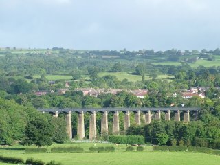
Area of 19th and early 20th industrial expansion including limestone quarrying, lime burning and industrial ceramics and associated workers’ housing spanning the Dee valley to either side of the Pontcysyllte Aqueduct.

Historic background
From the early medieval period the area fell within the Welsh kingdom of Powys and from the late 12th century within the commote of Nanheudwy in the subdivided northern portion of the kingdom known as Powys Fadog. Following the Edwardian conquest in the late 13th century the area formed part of the marcher lordship of Chirk and in the 14th century may have formed part of the forest of Isclawdd within the lordship. Native Welsh farming communities at Cysyllte are first recorded in the late 14th century. Following the Act of Union in 1536 the area became part of the newly created county of Denbighshire. Part of the area was transferred to Wrexham County Borough Council in 1997.
Key historic landscape characteristics
The character area spans the northern and southern sides of the Dee valley with the Pontcysyllte Aqueduct at its centre, and includes the settlements of Trevor and Froncysyllte. Topographically the area falls between about 60–280 metres above sea level. The northern and eastern parts of the area are composed of sandstones and marls associated with the Coal Measures overlain by glacial till and recent alluvial deposits in the valley bottom. At Froncysyllte, on the south side of the valley, is an isolated block of Carboniferous Limestone. The present-day land use is predominantly for housing but includes some former manufacturing and processing complexes and areas devoted to sporting and leisure activities. An area of pasture on the northern bank of the Dee has been included in this area because of the essential setting it provides for the Pontcysyllte Aqueduct.An important river crossing of the river Dee on the route between Chirk and Wrexham appears to have been first achieved by the construction of the stone-built Pont Cysyllte in the 1690s. The bridge is mentioned by the antiquary Edward Lhwyd in the early 18th century probably before the substantial reconstruction of the bridge later in that century.
The coming of the canal and the construction of the Pontcysyllte Aqueduct between 1795 and 1805 greatly encouraged the industrial exploitation of the area which has now almost completely masked a earlier and probably medieval landscape of small irregular fields. Canal-side limekilns were in operation at Froncysyllte from the end of the 18th century onwards, producing lime for both agricultural and industrial purposes and transported as far as Cheshire, Staffordshire and the Midlands. The kilns were supplied by stone quarried in the Pen y Graig quarries on the hillside above Froncysyllte, being transported by a series of tramroads and inclines, lime being produced by coal imported by barge from the Ruabon coalfield. The small nucleated settlement at Froncysyllte with its miners’ and kiln workers’ cottages, nonconformist chapels, church and public houses having come into existence during the 19th century along Telford’s Holyhead Road (A5) and on the hillside to the south. The local lime industry underwent a period of decline towards the end of the 19th century though quarrying for limestone was to continue at the Pen y Graig quarries up to the 1950s.
The construction of the canal wharf at Trevor together with the opening of the Vale of Llangollen Railway in the 1860s fostered the development of a focus of industrial activity here, to the north of the river. The availability of Coal Measures marls from opencast quarries and deeper mines, combined with the ready availability of coal from the Ruabon Coalfield gave rise to brick and tile works from about the 1850s onwards. The Tref-y-nant brickworks subsequently developed on an ideal site just to the north of the canal wharf and alongside the railway, producing at first firebricks and chimney pots and ornamental terracotta, but specialising in glazed sanitary pipes, for which there was a rapidly expanding market following the passing of the Public Health Acts of the 1840s and 1850s. The works continued in operation until the 1950s following which practically all of the buildings and structures on the site were demolished.
In the second half of the 20th century chemical and industrial processing works were established in part of the eastern side of the area largely as an offshoot of the Monsanto industrial complex in the adjacent community of Acrefair.
The closure of the Pen y Graig quarries at Froncysyllte in the 1950s released land which enabled the expansion of the settlement with local authority housing, meeting the need for housing for people working in the neighbouring expanding industrial centres of Acrefair and Cefn Mawr. Former farmland at Trevor was likewise developed for housing in the later 20th century and early 21st century.
Sources
Baughan 1980; Breese 2001; Burnham1995; Cadw Listed Buildings Lists; Clwyd Fine Arts Trust nd; CPAT Historic Environment Record; DCMS 1999; Hadfield 1969; Harper 1902; Hubbard 1986; Jervoise 1932; Jones 1932; Lewis 1833; Lhwyd 1909-10; Martin 1999; Musson 1994; Owen and Silvester 1993; Pellow and Bowen 1988; Pratt 1990; Quartermaine et al. 2003; Quenby 1992; Sherratt 2000; Sivewright 1986; Williams 1999; Wilson 1975; Wrexham 2003For further information please contact the Clwyd-Powys Archaeological Trust at this address, or link to the Countryside Council for Wales web site at www.ccw.gov.uk.
Privacy and cookies