
|
Back Home |
|
|
Index to Montgomeryshire Churches survey |
Montgomeryshire Churches Survey
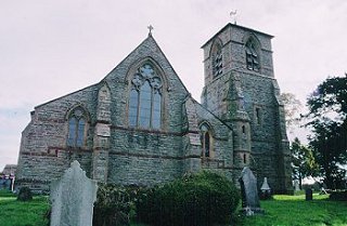
Church of St Michael , Forden
Forden Church is in the Diocese of St Asaph, in the community of Forden in the county of Powys. It is located at Ordnance Survey national grid reference SJ2272101117.The church is recorded in the CPAT Historic Environment Record as number 16418 and this number should be quoted in all correspondence.
Summary
The church of St Michael lies in the dispersed settlement of Forden about 4 miles south of Welshpool. The present building was constructed in 1867 to replace a small medieval single-chamber church which remained standing and in use while the present church was being erected a short distance to the south. Nothing of the earlier building survives above ground, and the only pre-19thC furnishing to survive is a font bowl of 1794. The irregularly-shaped churchyard retains some 18thC gravemarkers.
A 19thC church, built in Decorated style to the design of Thomas Nicholson of Hereford in 1867.
Parts of the following description are quoted from the 1979 publication The Buildings of Wales: Powys by Richard Haslam
History
The early church at Forden was a chapel attached to the church at Chirbury. There is nothing here to suggest an early medieval origin.
Forden chapel was not included in the 13thC Taxations, but does appear in the Valor Ecclesiasticus of 1535.
In 1830 a transept was added to the north side and this incorporated a gallery. A sketch of the old church appears in 'Montgomeryshire Collections', and shows a wooden belfry with a pyramidal roof and a weathercock.
By the middle of the 19thC the old church was deemed to be in a dangerous state and a faculty was granted in 1864 to take it down and build a new church. The foundation stone was laid in 1865 and the building was consecrated in 1867. The architect was Thomas Nicholson of Hereford. During the work the old church was left standing and continued to be used for services.
New heating apparatus was installed in 1917.
Architecture
The present structure consists of a nave with north and south aisles, a chancel, a northern vestry with a boiler room beneath, an organ chamber also on the north, and a western tower attached to the south -west corner of the south aisle. The church is aligned south-west to north-east but for the purposes of description 'ecclesiastical east' is adopted here.
Fabric: entirely of medium-sized blocks of yellow-grey Minera limestone, with Red Grinshill sandstone dressings. Fairly regularly coursing.
Roofs: slates, notched ceramic ridge tiles, sandstone coping and cross finials.
Drainage: 19thC guttering and downspouts lead to soakaways. Chippings around the south tower, part of the south side of the nave, and perhaps the south wall of the chancel hint at the presence of a wall trench.
Note: as the church is wholly 19thC the following description is no more than a summary. A near contemporary description is given in Vize 1883.
Exterior
General. A basal plinth with red sandstone capping runs all round the church and tower at a height of c.0.5m.
Tower. General. Three-stage tower with pyramidal slated roof surmounted by weathervane. Plinth and three sandstone string courses, the uppermost of which creates a continuous hoodmould over the belfry windows. Stepped angle buttresses. On the west side, a square staircase turret, which becomes octagonal at a higher level, projects from the wall, rising to first floor height; slit windows. South wall contains a two-centred entrance arch in Early English style with ringed shafts and floriated capitals, and the louvred belfry windows have two-centred arches over paired lancet lights with quatrefoils in Y-tracery.
Nave and aisles. General. Stepped buttresses. Two decorative horizontal bands of red sandstone, the lower one continuous, too, around the chancel, the upper one intermittent. Paired lancets with round tracery lights, usually with hoodmoulds and floriate stops. At the east end of the south and north walls are dormers, beneath which are windows with three cusped lights and hexafoil tracery, and hoodmoulds with head stops. Single trefoil-headed lights in the east walls.
Chancel. General. Angle buttresses; windows as nave except for the east window which contains three trefoil-headed lights with three equal sized rose multifoils above in plate tracery, and a hoodmould with head stops. At the base of the wall is a foundation stone with the date 1865. On the south side a priest's door to either side of which are two-centred windows containing two trefoil-headed lights with trefoils above. A brick chimney stack rises through the north side of the chancel roof.
Interior
Tower. General. Ground floor forms the porch. Tiled floor, deeply splayed apertures, planked ceiling. Pointed arched doorway to nave, and a shouldered arch to the tower staircase against the west wall. Stone benches along the east and west walls, and resting on each one is a wooden gravemarker.
Nave and aisles. General. Tiled floor with raised wooden flooring under the benches. An arcade of four bays on each side of the nave, with two-centred arches supported on columns with octagonal capitals carved with crocketted foliage in Early English style. Chancel arch of red and white stone with a narrow pointed head springing from short greenish-black marble ring shafts with carved capitals sitting on head corbels. Nave has a scissor-braced roof with dog tooth friezes on the wallplates; aisle roofs slope down to north and south with exposed rafters. One 19thC marble memorial on the east wall of the south aisle, and one of the 20thC on its south wall.
Chancel. General. Encaustic tiled floor. Longitudinal oak choir stalls. Stepped entrance from nave and five steps lead up to the sanctuary. Credence bracket on north wall, a sedile below south window in the sanctuary, and the Decalogue on boards on either side of the altar. A four-bay roof formed by four arch-braced scissor trusses with intermediate, ordinary scissor trusses; exposed purlins and battlemented wallplates.
Churchyard
The irregularly-shaped enclosure has been enlarged on the west in the last one hundred years; previously it was sub-rectangular, though there is a vague hint of curvilinearity on its south side. However, a new burial ground was consecrated in the 1920s on the south side of the main road opposite the church. The ground in the old churchyard slopes away on the north and west sides towards a brook. It is reasonably well-kept on the south and west sides around the church, but older graves are overgrown on the perimeters.
Boundary: hedged boundary on all sides. Slight scarp on the north side where the old boundary was removed.
Monuments: mainly chest tombs, railed graves, some crosses and large slabs of generally 19thC date; earlier slate and stone slabs of the period 1812-1820s are located near the south boundary hedge beneath the older yew trees. The earliest slabs noted are on the south side of the church, dating to 1765 and 1795.There are reputedly 634 unmarked graves in the churchyard dating from 1795 onwards before the House of Industry at Forden cosecrated its own burial ground in 1818.
Furniture: sandstone sundial located on the west side of the south path. A circular bowl with a leaf pattern carved around it, a circular stem and a square plinth now standing on a circular base. The dial and gnomon were a 1777 gift of the Churchwardens, made by Richard Harper of Salop and inscribed 'I Steal Upon You'.
Earthworks: the original west boundary pre-dating the churchyard extension on the north-west side can still be traced. The churchyard is not raised. The site of the earlier church was to the south of the present one - there are undulations here and it is assumed that the foundations of the old church still lie below ground.
Ancillary features: pair of wrought iron gates form the main entrance from the south and a tarmac path leads up to the tower door. A grassed-over path leads around the church and out to the western burial ground. A disused double gate and a single gate are located in the north-east corner and this was formerly the old entrance to the church.
Vegetation: the oldest yew trees are located on the south side of church: three on the roadside hedge boundary and two near the south-west corner of tower. An old yew on the west side of the south path blew down in the 1970s and several Irish yews were planted to take its place.
Sources consulted
Cadw Schedule of Listed Buildings 1998
CPAT Field Visit: 5 February 1995 and 18 February 1998
Eisel 1986, 177
Faculty: St. Asaph 1920 (NLW)
Haslam 1979, 102
HRO Church Records: 1864 - papers relating to demolition.
NMR Aberystwyth
Powys SMR
Ridgway 1997, 81
Vize 1883
Click here to view full project bibliography
Please note that many rural churches are closed to the public at certain times. It is advisable to check when the church will be open before visiting. Information about access, or how to contact parish clergy, can often be obtained from the relevant Diocesan Office which can be found through the Church in Wales website. Further information about Forden Church may also be found on the St Asaph Diocese website.
This HTML page has been generated from the Cadw Churches Survey database & CPAT's Regional Historic Environment Record - 17/07/2007 ( 22:02:05 ).
 The CPAT Montgomeryshire Churches Survey Project was funded by Cadw as part of an all Wales survey of medieval parish churches.
Further information about this and other churches surveyed is available from the Regional Historic Environment Record, Clwyd Powys Archaeological Trust, Curatorial Section, 41 Broad Street, Welshpool, Powys, SY21 7RR tel - (01938) 553670, fax - (01938) 552179, email - chrismartin@cpat.org.uk, website - www.cpat.org.uk.