
|
Back Home |
|
|
Index to Brecknockshire Churches survey |
Brecknockshire Churches Survey
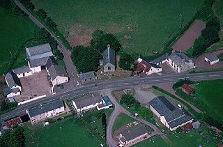
Upper Chapel Church
Upper Chapel Church is in the Diocese of Swansea and Brecon, in the community of Merthyr Cynog in the county of Powys. It is located at Ordnance Survey national grid reference SO0072740580.The church is recorded in the CPAT Historic Environment Record as number 20106 and this number should be quoted in all correspondence.
Summary
Also known as Capel Dyffryn Honddu, Upper Chapel some 10km to the south of Builth Wells, lacks a dedication. It has been rebuilt perhaps in the 18thC or early 19thC and nothing is known of its predecessor. It contains no features of medieval origin and its churchyard is only partially curvilinear.
Rebuilt in uniform masonry with simple windows at a date which has not been registered. Could be 18thC and certainly before the general phase of Victorianisation.
Parts of the following description are quoted from the 1979 publication The Buildings of Wales: Powys by Richard Haslam
History
Nothing is known of the earlier history of this chapel. One suspects it may have originated as a chapel of ease, perhaps in the Middle Ages, but there is nothing to corroborate such a theory. No medieval references have been encountered and there are few details even in the post-medieval era.
Dawson recorded that the register was commenced in 1826 and the communion plate was dated 1889. There was a schoolroom at the south-west angle in the 19thC.
Architecture
The church comprises a small single-cell structure with no external differentiation between nave and chancel. There is a south porch set almost centrally on the south side, and a bellcote at the west end. It is oriented west-north-west/east-south-east but 'ecclesiastical east' is adopted in this report.
Fabric: medium sized blocks and some slabs of red and grey sandstone, irregularly coursed; ashlar quoins.
Roof: slates with lead covering along ridge. Stone bellcote at west end with one bell under a pitched roof.
Drainage: concrete-lined gullies on all sides but the west, and extending round east and west sides of porch. There are downpipes on the west so conceivably a sub-surface gully.
Exterior
Nave and chancel. North wall: two single light windows, effectively broad lancets, dressed stone jambs and arch, not chamfered. Remnants of plaster.
East wall: window has two lights and Y-tracery, but its stonework the same as the windows on the north side.
South wall: two windows as north wall. Plaster remnants.
West wall: no windows but plaster remnants; formerly ivy covered.
Porch. General. Standard masonry. Plaster remnants on all three sides.
South wall: narrow two-centred arch with dressed arch stones but quoins rather than jambs. Wooden gable with lamp set in it.
Interior
Porch. General. Flagged floor; walls plastered and whitewashed; arched ceiling, also whitewashed. North wall has a two-centred arched doorway, comparable in materials to windows.
Nave. General. Austere interior. Flagged floor with benches set on flush boarding. Plain walls with narrowly splayed window embrasures and windows themselves in wooden frames with some stained glass; ceiling has a triangular pitch with no timber visible.
Chancel. General. On same level as nave, but for the fact that raised on wooden boards; one step up to sanctuary. Walls and roof as nave. East window holds more stained glass.
Churchyard
The churchyard lies on a very slight slope, just perceptible internally, for its position and that of the accompanying settlement is a spur location above the confluence of the Honddu and a tributary. It is raised on the east and south sides above the road but not on the north or west sides, and is in part curvilinear.
The churchyard is well kept and still used for burial.
Boundary: a mortared stone wall on the south and east, and a pletched hedge on the north and west.
Monuments: generally sparse and these almost entirely 20thC.
Furniture: none.
Earthworks: about 10m west and north of the perimeter hedge is a low scarp suggestive either of a former boundary or more likely perhaps a track around the enclosure which is depicted on the Tithe survey. The boundary here has a curve to it and in this respect the 1st edition OS map is more accurate than its modern successor.
Ancillary features: single unadorned iron gate give access to churchyard from east. Concrete path to porch.
Vegetation: several quite substantial yews and a couple smaller examples scattered around the churchyard, some just inside the perimeter.
Sources consulted
CPAT Field Visit: 21 November 1995
Dawson 1909, 235
Martin and Walters 1993, 123
NMR Aberystwyth
Click here to view full project bibliography
Please note that many rural churches are closed to the public at certain times. It is advisable to check when the church will be open before visiting. Information about access, or how to contact parish clergy, can often be obtained from the relevant Diocesan Office which can be found through the Church in Wales website. Further information about Upper Chapel Church may also be found on the Swansea and Brecon Diocese website.
This HTML page has been generated from the Cadw Churches Survey database & CPAT's Regional Historic Environment Record - 17/07/2007 ( 22:01:10 ).
 The CPAT Brecknockshire Churches Survey Project was funded by Cadw as part of an all Wales survey of medieval parish churches.
Further information about this and other churches surveyed is available from the Regional Historic Environment Record, Clwyd Powys Archaeological Trust, Curatorial Section, 7a Church Street, Welshpool, Powys, SY21 7DL tel - (01938) 553670, fax - (01938) 552179, email - chrismartin@cpat.org.uk, website - www.cpat.org.uk.