
|
Back Home |
|
|
Index to Brecknockshire Churches survey |
Brecknockshire Churches Survey
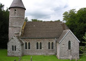
Bettws Penpont Church
Bettws Penpont Church is in the Diocese of Swansea and Brecon, in the community of Trallong in the county of Powys. It is located at Ordnance Survey national grid reference SN9728728525.The church is recorded in the CPAT Historic Environment Record as number 16934 and this number should be quoted in all correspondence.
Summary
Bettws Penpont church has no known dedication. It lies in the valley of the Usk 7km west of Brecon. A medieval chapel on this site is a possibility but the present building is almost entirely a Scott creation of the 1860s and contains virtually nothing that pre-dates his edifice.
Rebuilt in 1864, incorporating a little of an earlier tower.
Parts of the following description are quoted from the 1979 publication The Buildings of Wales: Powys by Richard Haslam
History
On the basis of a statement in a law suit of 1738 which claimed that 'the chapel had belonged to Castell Einon Sais or some religious house' it has been suggested - though not convincingly - that the chapel was founded in the 12thC or 13thC.
It formerly went under the name of Bettws or Capel Bettws, and the first identifiable church on the site was a chapel of ease to Llanspyddid, erected by the Williams family, owners of the nearby house of Penpont. Its erection is not dated but by 1738 it was ruinous. A new chapel was built in 1789 and this probably included a tower with a bee-hive top similar to that on the old church at Llansantffraid-juxta-Usk. It was at this time too that the churchyard was walled.
In 1864 the chapel was rebuilt in Early English style by Sir George Gilbert Scott. It was given the status of parish church in 1880.
Architecture
Bettws Penpont church comprises a nave and chancel in one, the latter having an apsidal east end, a round tower at the west end, an organ chamber off the south side of the chancel, and a vestry off the south side of the tower. It is oriented south-west/north-east but 'ecclesiastical east' is used here.
Fabrics: 'A' is of shaped blocks and slabs of sandstone, mostly grey but some red, randomly coursed; freestone dressings. 'B' is similar but the blocks are not so regular; heavy pointing. Possibly re-used material. 'C' is similar to 'B' but grey sandstone throughout.
Roofs: reconstituted clay tiles.
Drainage: stone drain along north and south sides.
Exterior Nave and chancel. General. Fabric 'A' throughout. Main doorway on north side. Wholly Victorian.
Tower. General. Circular with conical roof. In Fabrics 'B' and 'C', the windows all with sandstone dressings dating from 1864. Most of tower is in 'B', but on the north side the first 4m-5m is in 'C' and this appears to be the sole survival from the 18thC chapel. The earlier tower seems to have had a greater diameter than its successor, so to accommodate the curve of the 18thC masonry a wing wall was built out from the nave. The west and south sides of the tower are completely Victorian.
Interior General. All floors of flagstones, partly carpet-covered. Griffiths noted the re-use of a graveslab of 1762. Walls completely whitewashed, except for window dressings. Nave has scissor-beam roof, the chancel a hemicyclical wood-ribbed vault. Tower forms a narrow west apse and serves as a baptistry.
Churchyard
The churchyard occupies level ground, a little above the valley floor of the River Usk which flows past the site a short distance to the north, and to the west of the churchyard a small stream originating on Mynydd Illtyd runs northwards to join the river. Its shape has an irregular D-shaped outline.
It is reasonably well-maintained and is still used for burial.
Boundary: on the south is a stone wall defining the perimeter beside the main road. This is transformed on the east into a low bank with a stone facing, the external ground level higher than the churchyard interior. Another stretch of wall about 1m high is visible on the north but this gives way to a scarp bank surmounted by yew trees opposite Penpont House and in this form the boundary continues around the west.
Monuments: these lie in a fairly dense crescent around the north side of the church, and there are a few scattered around the south side. East of the chancel there are memorials of 1767 and 1785, with perhaps a few other early, but now illegible examples.
Furniture: none.
Earthworks: none of any significance.
Vegetation: large numbers of yews, some seemingly quite ancient.
Sources consulted
CPAT Field Visit: 14 September 1995
Dawson 1909, 9
Haslam 1979, 367
NMR Aberystwyth
Powys County Council leaflet: 1978
Click here to view full project bibliography
Please note that many rural churches are closed to the public at certain times. It is advisable to check when the church will be open before visiting. Information about access, or how to contact parish clergy, can often be obtained from the relevant Diocesan Office which can be found through the Church in Wales website. Further information about Bettws Penpont Church may also be found on the Swansea and Brecon Diocese website.
This HTML page has been generated from the Cadw Churches Survey database & CPAT's Regional Historic Environment Record - 17/07/2007 ( 22:01:06 ).
 The CPAT Brecknockshire Churches Survey Project was funded by Cadw as part of an all Wales survey of medieval parish churches.
Further information about this and other churches surveyed is available from the Regional Historic Environment Record, Clwyd Powys Archaeological Trust, Curatorial Section, 7a Church Street, Welshpool, Powys, SY21 7DL tel - (01938) 553670, fax - (01938) 552179, email - chrismartin@cpat.org.uk, website - www.cpat.org.uk.