
|
Back Home |
|
|
Index to Brecknockshire Churches survey |
Brecknockshire Churches Survey
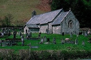
Church of St David , Llanwrtyd
Llanwrtyd Church is in the Diocese of Swansea and Brecon, in the community of Llanwrtyd Wells in the county of Powys. It is located at Ordnance Survey national grid reference SN8636047793.The church is recorded in the CPAT Historic Environment Record as number 16895 and this number should be quoted in all correspondence.
Summary
St David's Church occupies an isolated position above the River Irfon some 5km from Llanwrtyd Wells. At the heart of the present structure may be 14thC or perhaps 15thC masonry but much of the structure could be 16thC, and there has been subsequent rebuilding and renewal. Its rood screen and loft have gone but the mural stair survives, and their is a medieval font and an early medieval pillar stone. The churchyard is partially curvilinear, and an early medieval foundation on this spot seems very likely.
It is difficult to phase the building because of the irregularity and homogeneity of the masonry.
Nave may originally have been 14thC, perhaps partially rebuilt and extended westwards in 16thC, and its major windows also 16thC, though much renewed.
Small chancel with virtually no diagnostic features. Claimed to be 16thC, but has probably seen considerable rebuilding.
Parts of the following description are quoted from the 1979 publication The Buildings of Wales: Powys by Richard Haslam
History
The early history and subsequent development of this remote church are unrecorded and there is no mention of it in the 13thC Taxatios or the Valor Ecclesiasticus of 1535. However, the location and churchyard morphology do suggest an early medieval foundation.
William Williams Pantycelyn, the famous hymn writer, was the curate here in 1740-42.
The church was restored by C. Buckeridge in 1862, and Glynne when he visited it in 1867 found it "nicely restored and in good condition".
It remained the parish church until St James was built in Llanwrtyd Wells in 1896.
Further work was done on it in 1935. Roof repairs in 1969 revealed the rood loft stairs.
Architecture
A small church with a nave and west bellcote, a comparatively small chancel and a south porch. The church is oriented almost exactly east to west.
Fabrics: 'A' consists of irregular blocks and slabs of grey and brown rubble ranging from coarse sandstone through to (?) mudstone, shale and large worn pebbles, random coursing; larger blocks for quoins, some of them dressed. 'B' of small to large blocks of fine sandstone, little more than a variation of 'A'.
Roofs: slates with reconstituted clay ridge tiles; metal cross finials to porch and east end of nave, and a larger one in stone on chancel.
Bellcote is rectangular with a concrete capping, not slated; one bell with openings on east and west.
Drainage: a slight depression around south side of nave is suggestive though not conclusive, and there is nothing obvious elsewhere, but for a brick and slab opening by the west porch wall.
Exterior
Nave. General. Fabric A. Chimney rises through the roof on the north side.
North wall: base of wall battered to height of c.0.7m at north-west corner, c.1.2m at north-east; wall face exhibits remnant limewash traces as well as heavy pointing. Three windows, all rectangular with labels. From west i) three lights with trefoil tracery and ogee heads in brown sandstone weathering to grey, Victorian; ii) as i) but with two lights and the tracery slightly different, same sandstone and level of weathering; iii) window of three lights with four-centred almost segmental heads and sunken spandrels; mullions replaced but the heads, jambs and perhaps the label, all in red sandstone are probably original. No obvious signs of insertion for any of the windows.
East wall: 1.2m higher than chancel. Plain, heavy pointing and some remnant limewash.
South wall: battered to 1.5m at south-east corner, the masonry cleaner and less weathered than on the north. Features from west: i) blocked window or doorway, lacking dressings but having simple stone jambs, no head; ii) mural tablet of 1783 partly over i); iii) a blocked window, certainly shown on some plans and there is one vertical slab that could be a jamb, yet not wholly convincing; iv) standard Victorian three-light window with trefoiled tracery, ogee heads all in a rectangular frame with a label over. There is no convincing sign of insertion and it is conceivable that the whole wall has been rebuilt here - certainly the batter at the base of the wall fades to almost nothing; v) square-headed window with two lights having four-centred heads and a label over. Only the mullion has been replaced, and the wall batter is again obvious; vi) wall projects for rood stair housing, no batter, and large blocks for quoins but no masonry change; vii) small slit window illuminates stair, selected blocks for jambs; viii) mural tablet of 1787; ix) blocked slit window with grey sandstone jambs which could perhaps even have been a small lancet though there is too much mortar to be certain; very close to the rood stair housing and could be of earlier date?
West wall: battered to a maximum height of 0.6m. Plain but for a wide, blocked doorway with a four-centred arch, and chamfered dressings; no convincing signs of insertion or rebuilding.
Chancel. General. Standard 'A' fabric with inclusion of some larger blocks, particularly in north and south walls. Plinth at base, generally up to 0.5m. Not precisely aligned with nave.
North wall: plain wall with less limewash remnants than nave, and has outward lean. Disconformity at north-east angle with masonry at corner not flush with rest of wall, suggesting east end is rebuilt.
East wall: heavily pointed and with an inward lean. Victorian window of three lights with roundel above smaller, central one, a two-centred arch and, above it, a relieving arch. Possibly the whole wall rebuilt. Three 19thC grave slabs pinned against wall.
South wall: plain, with no plinth and a hint of a batter only towards the west end. Possibly considerable rebuilding. One mural slab of 1839.
Porch. General. Fabric 'B' in places, but could be no more than a variation in 'A'. Thought by Griffiths of RCAHMW to be of 19thC build, but re-using an earlier outer doorway.
East wall: plain, heavy pointing.
South wall: probably Fabric 'A'. Round-headed doorway with stopped chamfers on both sides. No gate or door.
West wall: plain.
Interior
Porch. General. Flagged floor, unplastered walls, and modern roof of collared rafters.
North wall: one step up to Victorian doorway with two-centred arch, rounded chamfers with broach stops and grey freestone dressings. Limewash on wall with thick coat behind roof collar. Slight disconformity in wall face at level of arch springers; wall above slopes in slightly and might be rebuilt.
East wall: slate slab bench with date 1961.
South wall: doorway has internal chamfer to jambs with stops that are not convincingly original; some replacement? Wooden beam built into wall above doorway, its purpose uncertain.
West wall: as east wall.
Nave. General. Tiled floor with concrete under the rear benches and flush wooden boarding under the front ones; two steps up to a raised dais at rear of nave. Plastered and whitewashed walls. Roof of seven bays with arch-braced collar trusses.
North wall: wall has outward lean; deeply splayed windows.
East wall: off-centre round-headed chancel arch with shallow chamfers. Early 19thC marble mural tablet to north of arch.
South wall: deeply splayed windows and door. Access to rood stair is a simple rectangular doorway, its large blocks painted not plastered, and now curtained off. In line with the two steps up to the dais is a slightly projecting plaster jamb rising to a height of c.2m and paralleled by a similar feature on the north wall. Almost certainly the rear of the nave was panelled off in the past to provide a school room or the like.
West wall: rectangular recess in wall, in line with but largely above the position of west door.
Chancel. General. One step up to tiled floor of chancel, one to sanctuary and one to altar. Walls as nave. Two-bay roof, lower than but otherwise similar to the nave. Internally chancel gives a greater sense of being out of alignment than on the exterior.
North wall: plain.
East wall: splayed window; mural slab of 1826 to south of it.
South wall: plain.
West wall: wall face is plain but it is inset at different heights on either side of chancel arch, indicative of some rebuilding.
Churchyard
Church and churchyard are set towards the bottom of a fairly steep slope just above the valley floor of the River Irfon. Its location has necessitated some artificial terracing.
Strongly curvilinear on the west and south-west, the rest of the perimeter which defines a rectilinear area, is of late 19thC/early 20thC origin. The earlier churchyard, however, also had straight boundaries on the north and east (see below).
It is well maintained and used for current burials.
Boundary: a mortared stone wall distinguishes the surviving part of the earlier enclosure, with hedges etc for the extension. There is some slight internal embanking on the south side, and overall there is little to suggest a raised churchyard.
Monuments: memorials are moderately dense throughout the churchyard, including the extension, but the lowest ground on the east has not been utilised. A number of railed plots of 19thC date lie to the north of the church, and to the south there may be some later 18thC flat tombs but their inscriptions are largely illegible.
Furniture: none noted.
Earthworks: to the north of the church is a scarp bank up to 1m high marking the former boundary. This swings round to the south and can be discerned along the east side, though its line does not appear to match exactly that shown on the 1st edition OS map.
Ancillary features: main entrance on south consists of a wooden kissing gate and a single metal gate. On the west double wooden gates give access to the extension. Roughly tarmac path.
Vegetation: no yews.
Sources consulted
Church guide 1992
CPAT Field Visit: 14 May 1996
Dawson 1909, 149
Glynne 1887, 282
Haslam 1979, 356
Martin and Walters 1993, 97
NMR Aberystwyth
Click here to view full project bibliography
Please note that many rural churches are closed to the public at certain times. It is advisable to check when the church will be open before visiting. Information about access, or how to contact parish clergy, can often be obtained from the relevant Diocesan Office which can be found through the Church in Wales website. Further information about Llanwrtyd Church may also be found on the Swansea and Brecon Diocese website.
This HTML page has been generated from the Cadw Churches Survey database & CPAT's Regional Historic Environment Record - 17/07/2007 ( 22:01:01 ).
 The CPAT Brecknockshire Churches Survey Project was funded by Cadw as part of an all Wales survey of medieval parish churches.
Further information about this and other churches surveyed is available from the Regional Historic Environment Record, Clwyd Powys Archaeological Trust, Curatorial Section, 7a Church Street, Welshpool, Powys, SY21 7DL tel - (01938) 553670, fax - (01938) 552179, email - chrismartin@cpat.org.uk, website - www.cpat.org.uk.