
|
Back Home |
|
|
Index to Brecknockshire Churches survey |
Brecknockshire Churches Survey
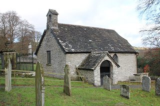
Church of St Mauritius , Alltmawr
Alltmawr Church is in the Diocese of Swansea and Brecon, in the community of Erwood in the county of Powys. It is located at Ordnance Survey national grid reference SO0733846879.The church is recorded in the CPAT Historic Environment Record as number 16705 and this number should be quoted in all correspondence.
Summary
St Mauritius' church, one of the smallest in Wales, is sited on the west bank of the River Wye, 5km south of Builth Wells. It has limited architectural interest for its windows are 18thC and much of the fabric was replaced in the 19thC. There is a medieval font and some of the post-medieval pews are retained at the back of the church.
Plan outline could be early as 13thC. Original walling survives on north and west sides of nave, and east wall of chancel; the date however remains uncertain, and conceivably this masonry could be as late as the 18thC windows that are placed in it. The south wall of the nave together with the north and south walls of the chancel, and probably most of the porch are 19thC.
Parts of the following description are quoted from the 1979 publication The Buildings of Wales: Powys by Richard Haslam
History
Nothing is known of the early history of the church. An early medieval origin might be suspected.
No medieval references have been encountered, and it is likely to have been a dependent chapel rather than a church.
Structurally there was some refurbishment in the 18thC and again at the end of the 19thC when the chancel was modified.
Architecture
St Mauritius' Church comprises a nave, hexagonal chancel, porch and west bellcote. The church is aligned fractionally south of west.
Fabrics: 'A' small to medium slabs of fine-grained sedimentary rock (perhaps a siltstone?), grey in colour though with occasional red sandstone lumps incorporated; some coursing; remnants of limewash left. 'B' as 'A' but more blocks of stone and also large, roughly dressed quoins in grey shaly sandstone. 'C' of thicker, more regular slabs of sedimentary rock, grey to dark grey.
Roof: shale slabs and ceramic roof tiles, except for vestry which has wooden shingles. No finials.
Bellcote above west gable with two opposing apertures, dressed stone; a single bell. 19thC.
Drainage: church is terraced into slope to depth of 0.6m at west end and shale slabs at base of the terrace would indicate some drainage function. A trench is visible, too, on south around porch and perhaps around chancel.
Exterior Nave. North wall: Fabric A; wall leans inwards slightly; basal courses to height of c.0.7m are rougher than rest of wall face and lack any limewash, perhaps a result of formerly being covered by soil? Two rectangular wooden windows with wooden lintels; that to west has one light, the more easterly two; lights have segmental heads.
East wall: chancel roof only c.0.2m lower so very little is visible.
South wall: no obvious limewash until the top 0.4m of the wall. The masonry has a fresher appearance with brown siltstone slabs and occasional red sandstone; this could be a result of less weathering or alternately because of rebuilding. In this context the base of the wall to a height of 0.3m is a projecting plinth which could perhaps be an earlier survival. One window with a four-centred arch and Y-tracery in wood, and rough stone utilised for jambs of embrasure. Set into wall and partly behind the porch roof is a timber which looks like the lintel of a blocked window for which there is no other evidence.
West wall: all 'A' except perhaps for extreme south-west angle which could be rebuilt; limewash remnants visible. Wooden rectangular window with two lights having segmental heads and a re-used wooden lintel. Wall is quite rough, and it is possible that this window has been inserted.
Vestry. General. Abuts north walls of both nave and chancel. In rough Fabric A; wooden window in west wall, door and window in east wall.
Chancel. General. In Fabric B on north and south, with some evidence of limewash on north side. Previously, there had been a standard rectangular chancel, but at the end of 19thC, the north and south walls were removed and were replaced by tangential walls that linked to the central part of the east wall to form a smaller chancel.
North wall: one lancet window with chamfered dressings in pink sandstone.
East wall: Fabric A with higher parts incorporating window in Fabric C; lancet window as on north side. Base of wall has projecting plinth.
South wall: standard lancet window and no plinth.
Porch. East and west walls: both plain, but former has a projecting foundation course.
South wall: wide four-centred archway turned in unchamfered blocks; in red sandstone and grey shaly sandstone. Probably of no great age. No gate.
Interior Porch. General. Flagged floor. Pitched ceiling is plastered.
North wall: wooden two-centred arched doorway. Remainder of wall is panelled, in part with old pews and perhaps other re-used timber.
East and west walls: wooden seats and, above this, panelling consisting of old pews.
Nave General. Flagged floor, carpeted over; no obvious heating grilles. Plastered walls. Roof of three bays has tie beams, king posts and raking struts, and collars, but plastered over at collar level; many of the timbers have stop-chamfered edges - thought to be late 18thC/early 19thC.
North wall: two splayed windows; old pews used to panel wall faces.
East wall: divide with chancel distinguished only by tie beam without king post and struts.
South wall: as north wall, but a single window and one 20thC brass.
West wall: one splayed window and a 19thC mural tablet.
Chancel General. One step up from nave; flagged floor with carpet over; sanctuary is a raised wooden plinth. Plastered walls. Roof is plastered over but shows purlins and rafters.
North wall: splayed window; simple passage to vestry.
South wall: splayed window; blocked recess looks as though it could have functioned as a priest's door, but nothing externally to suggest it was so used.
Churchyard
Alltmawr churchyard is small and irregularly D-shaped. Internally it slopes gently from west to east, and is set on a natural shelf above the valley floor of the River Wye, 200m to the east.
Its curvilinear perimeter on the north-east is not matched elsewhere, but there is a strong possibility that modifications have occurred to both the west and south-east sides, though these are now irrecoverable because of building and landscaping respectively.
The churchyard is well-maintained and still used for burial.
Boundary: an ivy covered stone wall defines the boundary on the south and this continues round the south-east, and the north-east where it is of double thickness. There is a high stone wall on the north, and buildings fronted by a small fence on the west. A slight scarp bank in front of the more northerly building could represent the earlier boundary. Around the eastern side of the churchyard, the external ground level is about a metre lower. Though this points to a raised interior, some of the height difference may be due to the local topography.
Monuments: not dense, but appearing in reasonable numbers; unmarked graves on south and modern burials to the east. The earliest marked graves have flat slabs of 1737/1756 and 1768.
Furniture: none.
Earthworks: none.
Ancillary features: there is an ungated entrance east of the church, a small ornamental gate giving access from Chapel House on the north, and the main entrance, also ungated, on the south-west. Grass paths.
Vegetation: one large yew tree in the south-west corner.
Sources consulted
CPAT Field Visit: 23 March 1996
Dawson 1909, 3
Haslam 1979, 281
NMR Aberystwyth
Click here to view full project bibliography
Please note that many rural churches are closed to the public at certain times. It is advisable to check when the church will be open before visiting. Information about access, or how to contact parish clergy, can often be obtained from the relevant Diocesan Office which can be found through the Church in Wales website. Further information about Alltmawr Church may also be found on the Swansea and Brecon Diocese website.
This HTML page has been generated from the Cadw Churches Survey database & CPAT's Regional Historic Environment Record - 17/07/2007 ( 22:00:30 ).
 The CPAT Brecknockshire Churches Survey Project was funded by Cadw as part of an all Wales survey of medieval parish churches.
Further information about this and other churches surveyed is available from the Regional Historic Environment Record, Clwyd Powys Archaeological Trust, Curatorial Section, 7a Church Street, Welshpool, Powys, SY21 7DL tel - (01938) 553670, fax - (01938) 552179, email - chrismartin@cpat.org.uk, website - www.cpat.org.uk.