Cymraeg / English

|
Bro Trefldwyn Historic Landscape |

|
Character area map |
Historic Landscape Characterisation
Bro Trefaldwyn:
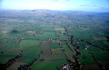
Gwern-y-go
Kerry and Churchstoke, Powys and Brompton and Rhiston, Shropshire
(HLCA 1075)
Low-lying land along the Caebitra valley, forming an important route into mid Wales via Sarn and Kerry, with Roman fort and marching camps, medieval grange, medieval and later mills.
Historic background
Early prehistoric activity in the area is represented by a Neolithic flint axe found near Brompton Hall, a Bronze Age leaf-shaped bronze spearhead found between Bacheldre and Crow Farm, and by cropmark ring-ditches possibly representing Bronze Age round barrows to the north and south of Brompton Hall, to the east of Pentrehyling, and possibly to the west of Gwern-y-go. Possible later prehistoric settlement is represented by a cropmark enclosure to the south of Perthybu. A Roman fort of the late 1st to early 2nd centuries, possibly housing a cavalry unit together with evidence for an extramural civilian settlment, was first identified from the air in 1969 just to the east of Pentreheyling Farm, together with a number of marching camps below Offa's Dyke and below Brompton Hall Farm. Brompton lies on the line of Offa's Dyke, and as its name implies it was probably a Mercian settlement, established by perhaps the 9th century, and probably falling within the compass of the settlement of Ristune given in the Domesday Book of 1086. The monastic grange at Gwern-y-go, belonging to the Cistercian abbey at Cwm-hir, had probably been founded by the middle of the 13th century. It derived its income partly from the profits of pastoral farming and partly from a mill. The abbey possessed all the lands and tenements in the township of Gwern-y-go and Caeliber-isaf on the sloping land to the north and in Hopton township, but the grange itself was separated from these by a ditch called the 'Grange Ditch', which has not been surveyed. The motte and bailey castle at Brompton had probably been erected by the late 12th to early 13th century, and was probably amongst the mottes in the Vale of Montgomery whose timber defences were required to be strengthened against possible Welsh attack in 1225. The grange chapel, possibly dedicated to St Michael, was served by a chaplain in 1397 and after the dissolution continued as a chapel of ease known as 'Chapel Gwernygo' into the second half of the 16th century. The precise location of the chapel is uncertain but was probably to the north of the present farm, and indicated by the field-names 'Chapel meadow' and 'Chapel close' on the Kerry tithe apportionment. Gwern-y-go mill continued in production during the 16th and 17th centuries, probably on the same site. It appears as flour mill in the mid 19th-century tithe apportionment, but seems to have ceased production by the 1880s. There area also references to a dyeing mill in the township in the mid 19th century, which was probably on the same site. Other mills in the character area include Bacheldre Mill, first recorded in the 1580s. By the early 19th century the area formed part of the townships of Bacheldre, Brompton, Hopton Issa and Ucha in the parish of Churchstoke, and parts of the townships of Caeliber Issa, Gwernygo, and Bachaethlon in the parish of Kerry.Key historic landscape characteristics
Low-lying land along the banks of the Caebitra brook, generally between 140-80m above Ordnance Datum. The underlying solid geology is composed of Silurian shales, the soils being fine silty and clayey stagnogleys, subject to seasonal waterlogging. Before the last glaciation the Afon Miwl probably flowed into the broad valley occupied by the Caebitra brook, having been diverted by ice and glacial debris blocking the valley near Sarn, just to the west of the historic landscape area. There ae areas of ancient replanted woodland in Gwern-y-go Wood.Modern settlement comprises a number of roadside houses and cottages and a small number of substantial widely-spaced farms, up to abut 1.5km apart, with small nucleated settlements around the mills at Bacheldre and Brompton.
The earliest surviving buildings are timber-framed, including the large early to mid 17th-century timber-framed houses Bacheldre House and Bacheldre Hall, the hall extended in Georgian style in the early 19th-century in stone, and a timber-framed cottage at Melin-y-wern. There is a large complex of brick farm buildings at Gwern-y-go, resulting from the planned development of the farm for animal husbandry in the early to mid 19th century by the Foxe family, associated with a rendered brick farmhouse dated to 1792. On the main road to the east of Sarn are a number of late Victorian houses and cottages, including Pitfield Villa in yellow and red brick.
The present-day pattern of large rectangular fields had developed by the early 19th-century, and remains little changed since that period, although some boundaries have been straightened and some removed. With the exception of a number of very small parcels, all the land in the character area had been enclosed by the early 19th century. Traces of ridge and furrow cultivation, possibly of medieval date, are recorded to the south of Perthybu and to the south of Mount Nebo farms. Present-day land-use is a mixture of arable and pasture.
The former mill at Gwern-y-go was fed by a long leat, about 1km in length, which may represent the medieval 'Grange Ditch'. Bacheldre Mill is a working flour watermill, parts of the present mill buildings in random stone and brick, dating to the mid 18th century. It was fed by an earlier long leat, about 800m long, taken from a weir on the Caebitra at Melin-y-wern, now replaced by a shorter leat and millpond fed by the Caebitra. A third mill, Brompton Mill, was also fed by the Caebitra.
Published sources
Allen 1986; 1988; 1991Barton 1999
Earp & Haines 1971
Eyton 1854-60
Fox 1955
Haslam 1979
King & Spurgeon 1965
Lavender 1951-52
Morris 1893
Morris 1982
Mountford 1928
Sothern & Drewett 1991
Thorn & Thorn 1986
Williams 1984; 1990
For further information please contact the Clwyd-Powys Archaeological Trust at this address, or link to the Countryside Council for Wales' web site at www.ccw.gov.uk.
Privacy and cookies