Cymraeg / English

|
Maelor Saesneg Historic Landscape |

|
Character area map |
Historic Landscape Characterisation
Maelor Saesneg:
Bettisfield
Bronington and Maelor South communities, Wrexham County Borough
(HLCA 1130)
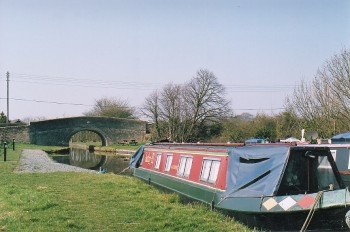 Rural landscape of scattered farms and irregular fields emerging from woodland clearance in the late medieval and early post-medieval period, with late linear settlement owing its origins to the coming of the canal and railway in the 19th century.
Historic background
Saxon settlement is indicated by the record of the manor of Bedesfeld in the Domesday survey, which was said to have been held by the church in the time of King Cnut (1016-35), the place-name probably derived from Betti's feld (Old English 'field'). The form or siting of this settlement is early unknown and it is possible that it may refer to a number of holdings dispersed around a manorial centre rather than a nucleated settlement. The inhabitants at that time included three knights (milites), who would have held land in return for military service, a priest, who it has been suggested may have been associated with an early church at Hanmer, about 4 kilometres to the north of the present settlement of Bettisfield, and what are described as 'three other men' (distinguished from serfs, villeins and bordars) who may represent a Welsh element in the population. Significantly, Domesday also records the presence of extensive areas of woodland, described as being three leagues by two leagues across, an area commensurate in size with the historic landscape character area. Extensive areas of woodland are recorded as being felled in the vicinity of Northwood in the adjacent areas of Shropshire between the late 15th century and the early decades of the 17th century, and it seems probable that large tracts of farmland in this area were similarly being created within this historic landscape area during that period. The earliest surviving maps dating to the late 18th century show a dispersed rural community within the area, the modern nucleated settlement at Bettisfield evidently largely owing its existence to the construction of the Ellesmere branch of the Shropshire Union Canal, completed in 1804, and by the Ellesmere and Whitchurch Railway, which began operations in 1863.Key historic landscape characteristics
Gently undulating pasture and arable farmland, generally between 80-100 metres above Ordnance Datum, with small marshy areas in poorly drained hollows towards the south and some heathland areas towards the west. The area is drained by to the north by steams which join the Emral Brook and ultimately the River Dee and to the south by streams which are tributaries of the River Roden in Shropshire.Fieldscapes are dominated by large irregular field patterns though with a distinct area of strip fields and reorganised strip fields associated with some relict areas of ridge and furrow in the area between Hill Farm and Knolls Farm, to the west of Bettisfield Park, that probably owes its origin to the enclosure of former medieval open fields. There is a diverse range of field boundary types, including mature mixed-species hedges with scatted mature oaks as well modern post and wire fences.
Present-day settlement is based on dispersed farms, between 0.5 and 1 kilometre apart, with the relatively recent linear settlement at Bettisfield, which as noted above appears to largely owe its existence to the coming of the canal and railway during the 19th century and which gave rise to a number of small-scale rural industries, including the former limekilns at Bettisfield, fed by lime and coal transported by canal barge.
The earliest surviving buildings in the area are high-status dwellings, which include The Ashes farmhouse, a late 16th-century, two storey timber framed house with an added timber-framed wing, and Bettisfield Old Hall, a 17th-century brick-built house, associated with a Tudor or Jacobean terraced garden. This replaced a probably timber hall in existence by the earlier 16th century, which at one time was in the ownership of a branch of the Hanmer family. An earlier pattern of settlement is represented by the moated site at Haulton Ring, to the east of Bettisfield Park, which may represent a colonising period of woodland clearance and settlement during the late 13th and early 14th century. A series of cropmark enclosures to the north of Blackhurst Farm are undated, but may belong to the later prehistoric, Romano-British, or medieval periods.
Sources
Baughan 1991Cadw 1995
Charles 1938
Frost 1995
Hubbard 1986
Manley 1990
Morgan 1978
Sawyer & Thacker 1987
Silvester et al. 1992
Smith 1988
Spurgeon 1991
Sylvester 1969
Listed Buildings lists
Regional Sites and Monuments Record
For further information please contact the Clwyd-Powys Archaeological Trust at this address, or link to the Countryside Council for Wales' web site at www.ccw.gov.uk.
Privacy and cookies