Cymraeg / English

|
Caersws Basin Historic Landscape |

|
Character area map |
|
|
More photographs |
Historic Landscape Characterisation
The Caersws Basin:
Rhos Ddiarbed
Llandinam and Mochdre communities, Powys
(HLCA 1185)
Irregular fieldscapes and dispersed farms possibly of medieval or earlier origin on the rising ground on the south and east of the Caersws Basin. Medieval motte and bailey castles associated with the Anglo-Norman conquest. Small nucleated church settlement of early medieval and medieval origin at Llandinam whose development was influenced by the turnpike road improvements in the late 18th and early 19th centuries and the coming of the railways and the patronage of the Davies family in the later 19th and earlier 20th centuries.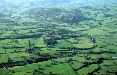
Historic background
The area formed part of the manorial townships of Maesmawr and Llandinam in the Montgomeryshire tithe parish of Llandinam and the township of Penstrowed in the tithe parish of Penstrowed.Key historic landscape characteristics
Generally gently sloping toe slope along the southern side of the Severn valley between Penstrowed and Llandinam, between a height of 130-280 metres. The soils are mostly seasonally waterlogged fine loams overlying clayey glacial drift deposits which historically have been economically best suited to stock rearing and some dairying on permanent grassland with some winter cereals. Fieldscapes are predominantly composed of large and small irregular fields probably representing gradual piecemeal clearance and enclosure from medieval or earlier periods onwards but with more regular field and straight-sided field patterning, in the areas to the south of Caetwp and in the area between Maesmawr Farm and The Moat respectively, which probably represent enclosure or landscape reorganisation associated with estate holdings in the post-medieval period. A small area of common encompassing the stream valleys just to the west of Plas Dinam was the subject of parliamentary enclosure in the early 19th century. Sinuous strips of ancient semi-natural woodland along a number of steep-sided stream valleys, together with a number of relatively small areas of conifer plantation of 19th and 20th-century origin on some steeper slopes. Modern land use changes include the golf driving range established near The Moat.Most of the placenames in the area relate to relatively recent settlement features but some indication of historic land use and vegetation is indicated by the woodland element celli (‘grove, copse’) in Gelli-dywyll and the implication of rough grazing by the element rhos in Rhos Ddiarbed.
Early land use and settlement of perhaps the Roman period is suggested by the cropmark of small rectangular ditched enclosures discovered by aerial photography near Gellidywyll and on a slight rise to the south of Llandinam Hall which appear to represent a cluster of such farmsteads in the Caersws area. The course of the Roman road southwards from Caersws to Castell Collen is thought to partly underlie the present A470 trunk road which runs through the area.
The church dedicated to St Llonio at Llandinam may have originated in the early medieval period. By the medieval period it was a clas church, one of the two mother-churches in the cantref of Arwystli and may have formed the focus of a small nucleated settlement from early times. The name of Llandinam first appears in the early 13th century and combines the elements llan (‘church’) and dinam (‘little fort’), the latter not having been closely identified with any particular site. The two earthwork castles at Bronfelin and Moat Farm motte and baileys on the rising ground to the south of the Severn, both appear to be associated with the period of Anglo-Norman conquest in the late 11th century, and although they may only have had a short-lived military significance they appear to have continued, perhaps as manorial centres, into the later medieval period.
The historic landscape character area includes a number of quite diverse and distinctive settlement landscapes, including the small nucleated settlement of early medieval or medieval origin at Llandinam, a dispersed pattern of farms of medieval and later origin, a cluster of probably of later 18th- and 19th- century encroachment cottages at Little London, and the 19th-century country house and associated buildings at Plas Dinam.
Apart from the medieval church the earliest surviving buildings in Llandinam are of 17th-century date and include several small vernacular buildings without land, clustered in an informal pattern reminiscent of squatting. Timber- framing was used in the earliest buildings but appears to have continued for those of lesser status: there are several cottages, as for example in Llandinam village and on the roadside south of it, which have the spindly timbers characteristic of late 18th-century or even early 19-century framing. There are also several good and more substantial 18th-century stone houses in the village. The later development of Llandinam was influenced by the turnpike road improvements in the later 18th and earlier 19th century, the coming of the railway in the later 19th century, and by the patronage of the Davies family in the later 19th and earlier 20th centuries. The roadside Lion Inn owes its existence to the turnpike road improvements, as does cast-iron Llandinam Bridge of 1846 crossing the Severn. The eminent Welsh industrialist, David Davies, a native of Llandinam, was one of the contractors for the bridge. Something of the character of the later focus of the village changed with the road widening and straightening schemes undertaken on the present-day A470 trunk road in the second half of the 20th century. The Llanidloes to Newtown railway which lay close to the river at Llandinam was completed in 1859, for which Davies was also the contractor. The railway finally closed in the 1960s, but the siting of the former station and sidings are still evident in the landscape. The fine bronze statue at the eastern end of the bridge of David Davies, shown wearing everyday clothes and examining a plan of Barry Docks, was erected ‘by public subscription’ in 1893, three years after his death. Davies was also the contractor and prime benefactor of the prominent roadside church of the Presbyterian Church of Wales (the denomination formerly known as the Calvinistic Methodists) built in a French Gothic style in 1873, where he and his family were regular worshippers. There was also formerly a Wesleyan Methodist chapel within the village. The character of the village is also influenced by several later buildings of which Davies’s descendants were benefactors, notably the Llandinam Institute with library and meeting rooms, built between 1905-10, and Trelonydd, a small planned estate of cottages around an informal green, built in about 1918 to house retired estate workers. The cottages, with white roughcast outer walls and small windows are built in a plain Arts and Crafts style.
The rural landscape of the character area is characterized by widely dispersed farms, some probably originating as freehold farms in the medieval and early post-medieval periods (as probably in the case of The Moat and Bronfelin Hall) and some as a result of improvements by the Llandinam Hall and Dinam Estates in the 19th century. Late medieval building traditions in the area are represented by Porth-gwibedyn which originated as a cruck-framed hall-house. The small farm at Caetwp, built in a later 19th-century Gothic style, was probably built or rebuilt as part of the Dinam Estate.
The cluster of cottages and small houses on the upland at Little London to the north-east of Llandinam, first recorded under its Welsh name, Lundain vach (‘Little London’) in 1740, most probably originated as encroachments on the once more extensive unenclosed commons in the area. The trackway running along the contour of the hill at this point has been thought to represent an earlier drover’s road.
The fine Victorian country house in a simple Arts and Crafts style at Plas Dinam and associated a series of offices east of the house and gardens was built on a new site in the 1870s for Captain J. O. Crewe-Read of Llandinam Hall. It was subsequently purchased by David Davies’s and occupied by his son.
The former use of water power in the character area is indicated by the place name Waulk Mill on the Ffinnant stream, just to the north of Llandinam, suggesting an earlier woollen mill.
Sources
Historic Environment Record; Cadw Listed Building descriptions; modern Ordnance Survey 1:10,000, 1:25,000 mapping and 1st edn Ordnance Survey 1:2,500 mapping; Anon 1886; Cadw 1999; Davies 1977; Evans 2004; Fisher 1917; Garbett-Edwards 1987; Lea 1975; Haslam 1979; Hogg and King 1963; Jones 1869; Jones 1983; Lewis 1833; Montgomeryshire Genealogical Society 1997; Morgan 2001; Pryce 2002; RCAHMW 1911; Soil Survey of England and Wales; Sothern and Drewett 1991; Spurgeon 1965-66; Stephenson 2005; Zaluckyj 2006For further information please contact the Clwyd-Powys Archaeological Trust at this address, or link to the Countryside Council for Wales' web site at www.ccw.gov.uk.
Privacy and cookies