Cymraeg / English

|
Caersws Basin Historic Landscape |

|
Character area map |
|
|
More photographs |
Historic Landscape Characterisation
The Caersws Basin:
Cerist
Caersws and Llandinam communities, Powys
(HLCA 1181)
Mixed fieldscapes on the relatively flat and lowlying ground along the lower Trannon and Cerist valleys, representing a combination of piecemeal clearance and enclosure from medieval times onwards, probable emparkment and landscape reorganisation in perhaps the early post-medieval period, and some reorganisation following the construction of the Van Railway and the diversion of a stretch of the river Cerist in the later 19th century.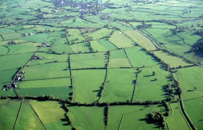
Historic background
The area formed parts of the manorial township of Wig in the tithe parish of Llanwnog, the townships of Trywythen and Carnedd in the parish of Llandinam, and the township of Bodaeoch in the parish of Trefeglwys.The farm at Park, formerly called Pen-prys, was a manor and possible administrative centre of the of commote of Arwystli Iscoed from at least the later 13th century with both arable and meadow land. The Augustinian canons of Haughmond were granted rights to feed their pigs in the wood of Pen-prys, presumably on more marginal land to the north or west of the manorial centre during the Middle Ages. Park had become a noted centre of horse breeding by the later 12th century and from at least the early 13th century appears to have been the focus of a hunting park. By the Tudor period, in the later 16th century it had become a royal horse stud, perhaps because of the quality of the lowland meadows in the valley of the lower Trannon and Cerist which were being enclosed at this time.
Key historic landscape characteristics
Generally flat and lowlying valley at a height of about 130 metres at the confluence of the Trannon and Cerist rivers and the Colwyn Brook, just to the east of the confluence of the Cerist and Garno with the river Severn. Several low hillocks to the north and west which rise to between 170-80 metres represent glacial drumlins which have had a local impact upon drainage patterns. The lower Cerist/Trannon below Carnedd was straightened presumably to ameliorate flooding between the early 1830s and later 1840s and in 1871 the channel of the Cerist upstream from Carnedd was realigned when the Van Railway was built. Soils in the valley bottom are derived from river alluvium and are composed of deep stoneless, fine silty and clayey soils which are have been naturally affected by waterlogging in places and which have economically been most suited to dairying and stock rearing on permanent grassland. The soils on the rising ground to the north are fine loamy or silty soils overlying either shale bedrock or fluviglacial gravel and drift, economically suited to stock rearing on permanent grassland and some cereals.A localized prehistoric lowland peat deposit, up to 2 metres deep and several hundred metres across, spans the eastern boundary of the character area, close to the confluence of the Garno and Severn.
The fieldscapes on the more elevated land to the north and west are dominated by large and small irregular field patterns which are likely to represent a piecemeal process of clearance and enclosure from medieval times or earlier. A distinctive pattern of more regularly shaped fields to the south-east of Park appears to represent landscape reorganisation associated with the Pen-prys manorial estate, and possibly dating from the mid 16th century or earlier. Straight-sided fields bordering the southern boundary of the area represent landscape reorganisation associated with the construction of the Van Railway and the canalization of the river Cerist in 1871.
Early settlement and land use is suggested by the chance find of a Neolithic or Bronze Age stone axe near Park. The course of the Roman road west of the Roman fort at Caersws runs though the area, part of which survives as a visible earthwork. Iron Age or more probably Romano-British agriculture is indicated by a cropmark enclosure representing a ditched enclosure near Maesgwastad, just to the north of the course of the Roman road.
The oldest surviving building in the area is the house of the Herbert family at Park (formerly Pen-prys) which was a high status building originally constructed in closely-studded timber towards the end of the 17th century parts of which survive behind a later exterior. This is associated with the adjacent farm complex of 19th century origin at Werglodd-Deg. Most of the houses and other buildings in the character area lie along the road to Trefeglwys or along the minor road to Park (following the course of the Roman road westwards from Caersws) are of 20th century date.
Sources
Historic Environment Record; Cadw Listed Building descriptions; modern Ordnance Survey 1:10,000, 1:25,000 mapping and 1st edn Ordnance Survey 1:2,500 mapping; Anon 1883; Barker 1997; Baughan 1980; Bridgeman 1868; Carr 1992; Collens 1988; Conway Davies 1945-46; Cozens 1953; Cozens et al. 2004; Clough and Cummins 1988; Davies 1810; Gibson 1998; Lea 1975; Leeks, Lewin and Newson 1988; Peate 1940; Pennant 1783; Soil Survey of England and Wales; Stephenson 2005; Walker et al. 2000For further information please contact the Clwyd-Powys Archaeological Trust at this address, or link to the Countryside Council for Wales' web site at www.ccw.gov.uk.
Privacy and cookies