Cymraeg / English

|
Caersws Basin Historic Landscape |

|
Character area map |
|
|
More photographs |
Historic Landscape Characterisation
The Caersws Basin:
Glasgoed
Caersws community, Powys
(HLCA 1180)
Predominantly irregular fieldscapes representing piecemeal woodland clearance and enclosure since at least early medieval times onwards.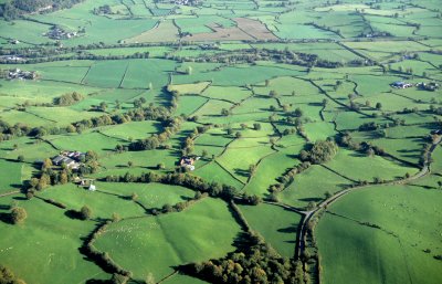
Historic background
The area fell within the manorial townships of Surnant and Wig in the Montgomeryshire tithe parish of Llanwnog.Key historic landscape characteristics
Hilly spur with steeply sloping sides between the valley of the river Garno to the east and the valley of the Trannon and Cerist to the south, between a height of 150-290 metres. The soils on the higher ground are well drained fine loamy and silty soils, shallow in places and overlying rock, economically best suited to stock rearing and woodland. The soils on the sloping ground to the east and south of the area are fine loamy and silty with impeded drainage in places, overlying glacial drift deposits, and best suited to stock rearing on permanent grassland. Fieldscapes are predominantly composed of small irregular fields with some larger irregular fields, which probably represent a process of piecemeal clearance and enclosure probably from medieval times and earlier. In the north-eastern corner of the area are a number of straight-sided fields north of Pen-y-coed which represent enclosure of an area of former open common grazing enclosed in the early 19th century. Small residual strips of ancient semi-natural woodland along some of the stream valleys.From the hilly nature of the area it is understandable that names including the element coed ('wood, trees') are frequent, as in Pen-y-coed, Coed-orddle, and Glasgoed.
Prehistoric settlement and land use is suggested by a stone axe found near Perth-eiryn.
The present-day settlement pattern is represented by widely dispersed farms of possible medieval or later medieval origin such as Pen-y-coed and Glasgoed, of which the latter expanded during the 20th century, with the erection of steel-framed buildings, together with a number of scattered cottages. The roadside house at Gate probably originated in the early 19th century, taking its name from the toll gate on the road to Trefeglwys which was formerly sited about 400 metres to the east.
Sources
Historic Environment Record; modern Ordnance Survey 1:10,000, 1:25,000 mapping and 1st edn Ordnance Survey 1:2,500 mapping; Jones 1983; Lea 1975; Morgan 2001; Soil Survey of England and Wales; Sothern and Drewett 1991For further information please contact the Clwyd-Powys Archaeological Trust at this address, or link to the Countryside Council for Wales' web site at www.ccw.gov.uk.
Privacy and cookies