Cymraeg / English

|
Back Home |

|
Historic Landscapes |
Historic Landscape Characterisation
Berwyn
|
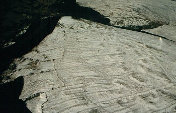
The following description, taken from the Historic Landscapes Register, identifies the essential historic landscape themes. This remote upland landscape occupies the westerly slopes of the Berwyn Mountains which physically and visually divide North from Mid-Wales. The area comprises tracts of rolling moorland pasture lying to the south east of the Dee valley, overlooking Llandrillo and having prospects to the Snowdonian massif beyond in the west. On the east side of the area, the central ridge of the Berwyn Mountains reaches a height of 827m above OD at the summits of Cader Berwyn and Moel Sych, but westwards the ground slopes gradually in a series of ridges to between 350–450m above OD, before dropping steeply into Cwm Pennant which adjoins the area on the west. In recent years, a combination of aerial photography and archaeological fieldwork has revealed a well-preserved relict landscape of historical agriculture, comprising extensive areas of field systems extending for over 3km above Cwm Pennant. The banks, ditches, enclosures and habitation sites of these field systems are believed to be variously of prehistoric and medieval origin. Gradually, fieldwork is revealing a complex pattern of settlement and farming where a number of terraced platforms, often occurring in pairs with vestigial stone foundations and presumably representing a ‘house and byre’, can be seen to be sited at the ends of associated paddocks and fields. Each complex perhaps represents a small medieval family farmstead. This pattern overlies the remains of an earlier period of land use, represented by stone cairns and circular stone hut foundations, probably belonging to the Bronze Age, and although the pattern here too is presumed to be one of small family farmsteads, the two episodes are separated by at least 2000 years of history. The pastures have been improved in this area during the last fifty years, which has masked some features, but many of the modern boundaries adopt the lines of their predecessors. The wide range of surviving earthworks and stone structures make this landscape an important archaeological resource for further study. In the central part of the area, the Cefn Penagored ridge, extending eastward between Nant Cwm Tywyll and Nant Esgeiriau, displays the remains of former prehistoric field systems consisting of low stone banks as well as several hut circles. This area contains a remarkably complete Bronze Age landscape of fields, huts and other habitations. The area also includes elements of the prehistoric spiritual landscape containing, as it does, a small stone circle and numerous burial cairns and standing stones. Smaller, but no less important groups of Bronze Age burial cairns occupy the northern fringe of the area at Moel Tyˆ Uchaf, while other groups occupy prominent positions on the local summits and along the crest of the central ridge to the east. One small area bounded by two streams, Nant Cwm Tywyll and Clochnant, has escaped recent improvements. Ffridd Camen is an area within the landscape of gently sloping hillside which contains well-preserved evidence of the area’s medieval cultivation. The remains of a substantial bank, stone-faced in parts, forms the divide between the stone-strewn land to the east and the cultivated, stone-cleared land to the west, which is subdivided into strips. Lying behind the bank are the remains of two longhouses and a stone pound. Ffridd Camen thus appears to have supported a selfcontained farm holding during the medieval period: fields cleared of stone lay on the lower slopes and the large bank was presumably constructed to keep stock out of the cultivated area, the whole being overlooked by the farmhouse. It seems likely that this example is representative of the general pattern of land use on the western slopes of the Berwyn Mountains during the medieval period. Traces of the former cultivated strips, encroaching on the upland moors, are still to be seen within the general area. These are delineated by low banks of earth and stone and are accompanied by numerous clearance cairns. While modern land improvement has greatly reduced the survival of many of the historic elements of the Berwyn Mountains landscape, this area still represents one of the best preserved landscapes of its type in central Wales. The remarkably high number of prehistoric features, resulting both from farming and ritual activity, and the equally impressive survival of medieval and later farming and settlement evidence contained in this relatively small area, make this a rare and important example of a historic landscape in Wales. |
For further information please contact the Clwyd-Powys Archaeological Trust at this address, or link to the Countryside Council for Wales' web site at www.ccw.gov.uk.
Privacy and cookies
