
|
Back Home |
|
|
Index to Radnorshire Churches survey |
Radnorshire Churches Survey
Church of St Meilig , Llowes
Llowes Church is in the Diocese of Swansea and Brecon, in the community of Glasbury in the county of Powys. It is located at Ordnance Survey national grid reference SO1924841728.The church is recorded in the CPAT Historic Environment Record as number 16899 and this number should be quoted in all correspondence.
Summary
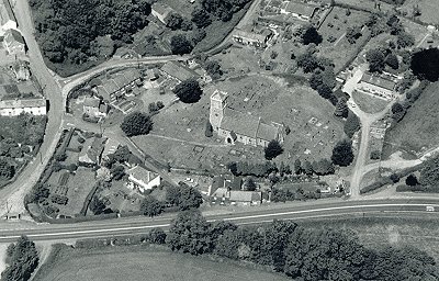
St Meilig's church is a moderately sized Victorian structure and only the tower dates back to the medieval era. It retains an early font and an 11thC inscribed cross but otherwise is devoid of early fittings. Set on the north side of the Wye valley the churchyard is sub-oval in shape, and may have housed a mother church from the 7thC onwards.
Lower part of tower perhaps medieval with Victorian insertions, and basal stage in different fabric and thus earlier than second stage; belfry stage may be largely Victorian.
Remainder of church is certainly Victorian, of 1853-5.
Parts of the following description are quoted from the 1979 publication The Buildings of Wales: Powys by Richard Haslam
History
St Meilig reputedly came from Clydeside in c.650 AD and founded a clas here. Certainly the location and the dedication are in keeping with an early medieval establishment.
The Taxatio of 1291 refers to 'Ecclesia de Lewas' at a value of ś8.
Little is known of the medieval structure, for the lower stages of the tower apart, nothing is left of it. The nave and chancel were entirely rebuilt in 1853-5 by W. J. Worthington.
Architecture
Llowes church comprises a nave and narrower chancel, a west tower, a south porch, and a vestry adjoining the north side of the chancel. The church is oriented south-west/north-east but 'ecclesiastical east' is adopted for this description.
Fabrics: 'A' is of small and medium blocks and slabs of sedimentary rock (sandstone and siltstone?), grey and brown in colour, randomly laid and giving an irregular appearance. 'B' presents a more regular appearance; though blocks and slabs are present, there is a predominance of long slabs showing some coursing; colour is more brown than grey. 'C' is best described as grey shaley sandstone blocks with some occasionally in red; the blocks are quite regular and some coursing is evident.
Roofs: slates with plain ridge tiles and cross finials to nave and chancel. Weathercock on the tower's pyramidal roof.
Drainage: there is nothing obvious on the north and east sides, and flower-beds edge the tower and part of the nave, with grass around the rest of the nave and the chancel. The only possible sign is a depression on the west side of the porch.
Note: only the tower is of any age, and consequently the description of the body of the building is a summary only.
Exterior
Tower. North wall: modern lean-to against this side. First stage in 'A' topped by chamfered string course; two blocked slit windows, the higher one has large blocks of brown sandstone for dressings while the lower is simply formed by selected masonry; a relieving arch in edge slabs for the lower window is interrupted by the upper slit. The second stage is in 'B' and terminates in a chamfered string course; it is notable for having yellow freestone quoins. There is a blocked window with large jambs of unchamfered but dressed stone. The third stage, again inset, looks like a mixture of 'B' and 'C', though the latter is rough. Belfry window has a two-centred arch, two louvred lights with trefoiled heads, a hoodmould with decorated stops and a relieving arch; the yellow sandstone dressings are Victorian, comparable with the nave. Fourth stage has battlemented parapet above a more elaborate string course with waterspouts at the angles.
East wall: nave roof reaches to the top of the second stage. Standard belfry window in third stage.
South wall: traces of a chamfered basal plinth; first stage contains inserted Victorian doorway with triangular head; then standard slit windows as on north though no relieving arch to lower. Second stage has clock face and two Victorian cusped lancets. Standard third stage, though Fabric 'B' lower down, and more 'B'/'C' higher up.
West wall: basal plinth as on south (but not visible on north side). Window removed from first stage, but?sill left in situ, and traces of limewash on the 'A' fabric. Two cusped lancets inserted. Second stage has a large Victorian west window of three lights, and the next stage has the standard belfry window.
Nave, Chancel and Porch. General. Wholly Victorian. Fabric of walls and buttresses all in 'C'. Windows to a standard pattern in yellow freestone with two-centred arches, cusped lights and stopped hoodmoulds; and an elaborate east window of four lights with Y-tracery. Porch has two-centred arched doorway with iron gates. Chancel has priest's door with complex moulded dressings and a triangular head.
Interior
Porch. General. Tiled floor; collar and rafter roof of no distinction. Wooden benches against side walls. South door has two-centred arch with ballflower stops to hoodmould. One step up into nave.
Nave. General. Tiled floor with carpet over, no obvious grilles to indicate underfloor heating; benches on raised wooden boarding. Plastered walls. Roof of eight bays with arch-braced collars and struts above, all supported on corbels. High chancel arch. North wall has marble mural tablet of 1854 and a World War One remembrance tablet, south wall a mural tablet of 1848. West wall sports a plan of the church (1855), an undated metal plaque recording the Incorporated Church Building Society grant in the 19thC, and a benefaction board referring to the will of John ap Hugh who died in 1671. A Victorian door leads to the tower and over it is a window installed in 1992 so that the chancel can be seen from the belfry.
Chancel. General. One step up to the chancel, another to the sanctuary. Tiled with carpet over. Choir stalls on raised wooden plinths. All windows have stained glass. North wall has five mural tablets ranging from 1805 to 1846; south wall has two of 1817 and 1846 with a 20thC brass.
Churchyard
The medium-sized churchyard is set close to the edge of the Wye Valley terrace and internally has a slight slope from north-west to south-east. A small stream occupies a shallow valley just to the west, and south-eastwards the ground drops almost immediately to the Wye valley floor.
It is well-maintained and is currently still in use for burial.
Boundary: north-east of the church is a drystone wall, with an internal embankment up to 0.4m high but no difference between the internal and external ground levels. It seems likely that this was not the original boundary line on this side but there is no indication of a predecessor. On the north-west the wall rises to nearly 1.5m but again the internal embanking apart there is no change in the ground level. But from the west side through to the south-east there is a considerable drop, in places up to 2m, with the wall acting more as a retaining line.
Monuments: these are set throughout the yard except in parts of the north sector. Nowhere, other than to the south of the nave and porch are they particularly dense. A few date from the earlier 18thC and though the majority of these are worn, they include a fine slab of 1684/1729 and another of 1707. 20thC graves lie to the north of the church.
Furniture: a sundial just to the south of the path and south-west of the church has the inscription 'The gift of John Williams B.D., Vicar of this parish 1810' on the gnomon, but the pillar carries the plaque recording its erection in 1954 to the memory of Kilvert.
Earthworks: viewed from the east and north-east the church is placed on a platform which under the chancel is about 1m high. Whether this is a deliberately constructed platform or a result of demolished material from the earlier church will be ascertained only by excavation.
Ancillary features: a metal gate and kissing gate provide an entrance in the north-east corner, there is a small metal gate to the house known as 'Church Row' on the north-west side, and at the south-west double metal gates and a kissing gate.
Vegetation: two yews on the west, one by the main gate, but otherwise conifers and other bushes, primarily around the perimeter. A tarmac path leads to the porch from the south-west, a grass one to the gate on the north-east.
Sources consulted
CPAT Field Visit: 22 March 1996
Davies 1905, 259
Haslam 1979, 256
Howse, 1949, 243
Click here to view full project bibliography
Please note that many rural churches are closed to the public at certain times. It is advisable to check when the church will be open before visiting. Information about access, or how to contact parish clergy, can often be obtained from the relevant Diocesan Office which can be found through the Church in Wales website. Further information about Llowes Church may also be found on the Swansea and Brecon Diocese website.
This HTML page has been generated from the Cadw Churches Survey database & CPAT's Regional Historic Environment Record - 17/07/2007 ( 22:02:45 ).
 The CPAT Radnorshire Churches Survey Project was funded by Cadw as part of an all Wales survey of medieval parish churches.
Further information about this and other churches surveyed is available from the Regional Historic Environment Record, Clwyd Powys Archaeological Trust, Curatorial Section, 41 Broad Street, Welshpool, Powys, SY21 7RR tel - (01938) 553670, fax - (01938) 552179, email - chrismartin@cpat.org.uk, website - www.cpat.org.uk.