
|
Back Home |
|
|
Index to Radnorshire Churches survey |
Radnorshire Churches Survey
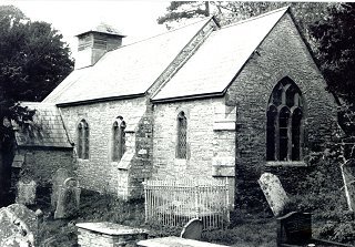
Church of St David , Llanddewi Fach
Llanddewi Fach Church is in the Diocese of Swansea and Brecon, in the community of Painscastle in the county of Powys. It is located at Ordnance Survey national grid reference SO1462045424.The church is recorded in the CPAT Historic Environment Record as number 16821 and this number should be quoted in all correspondence.
Summary
A small, rectilinear churchyard set into north slope of a valley carrying a small stream north-westwards towards the Bachawy; a remote location 2km south-west of Painscastle. St David's church was rebuilt in mid-19thC, leaving virtually nothing of earlier structure either inside or out.
Church rebuilt in 1860; only evidence of earlier structure is foundation at east end of chancel.
Parts of the following description are quoted from the 1979 publication The Buildings of Wales: Powys by Richard Haslam
History
The origin and development of this small church is unknown, and it does not figure in any of the medieval taxation records. As late as the 19thC it was a chapel attached to Llowes.
It was entirely rebuilt by Prichard and Seddon in 1860.
Architecture
St David's Church consists of a nave with west belfry, chancel, and south porch. Church is oriented west-north-west/east-south-east, but 'ecclesiastical east' is adopted here for descriptive purposes.
Fabric: slabs and blocks of shale of varying size, with some sandstone; larger blocks used for foundation courses and quoins; traces of former render.
Roofs: artificial 'slates' on body of building, but real slates on bellcote. Porch ridged in metal sheeting.
Drainage: church terraced into hillside on north and east, so terrace has drainage function; drainage trench visible on south side, but nothing obvious on west.
Exterior.
General. Church appears to have been almost completely rebuilt in 19thC so following description is a summary one only.
Nave and chancel walls have continuous chamfered plinth, though nave slightly wider than chancel. Victorian Gothic windows, but none on north side. Diagonal buttresses at west and east ends, and on south side of porch, angle buttresses at east end of nave.
East wall of chancel has projecting foundation, which rises in series of steps rather than being horizontal. Earlier wall fragment?
Bell-turret is square with pyramidal roof and louvred openings.
Interior
Porch. Flagged floor, ceiled, plastered walls.
Nave. General. Floor of stone flags, no re-use of gravestones; benches raised on wooden boarding. No evidence of underground heating voids. Roof ceiled, but two principal trusses with collars showing. Walls plastered and whitewashed. Fireplace in north wall, but no longer used. Ranged along north and south walls, panelling of earlier, but undated, pews.
Chancel. General. Chancel on same level as nave, but one step up to altar. Floor flagged. Roof and walls as in nave. North wall carries one mural tablet of 1850. Beneath altar one flagstone has initials M.P. and B.P.
Churchyard
Small, rectilinear churchyard set into north slope of a valley, with no indication that it has ever been modified or enlarged. Church itself terraced into slope to a depth in excess of 1.5m, and the bench occupied by churchyard is probably largely a function of centuries of use.
It is not well-maintained, is heavily overgrown on north side, and is actively used by badgers.
Perimeter is defined by a drystone wall, well-built but now collapsing. On west this is c. 0.8m high, on south it acts more as a revetment wall, crumbling away towards the south-east corner. At its soundest in vicinity on east gate, where perhaps 1.2m high. On north, it is in reasonable condition, the internal ground level at least 0.5m lower than the external level because of the natural slope. Blocked gateway in wall, west of north-east corner.
Monuments: spread along south side of churchyard with none to north. Not many in total, but because of small size of churchyard they are quite tightly packed. Earliest graveslab is of 1691, but this was taken out of church prior to 1983. Earliest upright stone of 1765, and some chest tombs of late 18thC/early 19thC.
Furniture: none seen.
Earthworks: surface of churchyard irregular but nothing of any significance obvious. House platforms outside churchyard.
Ancillary features: two small wooden gates give access to church, via grass path, on east side of churchyard.
Vegetation: four mature yews around southern perimeter: Yew Tree Conservation Group has certified that one could be 650 years old! Self-seeded bushes and small trees on north and west.
Sources consulted
CPAT Field Visit: 14 November 1995
Davies 1905, 255
Haslam 1979, 244
Howse, 1949, 259
Silvester 1994, 89
Click here to view full project bibliography
Please note that many rural churches are closed to the public at certain times. It is advisable to check when the church will be open before visiting. Information about access, or how to contact parish clergy, can often be obtained from the relevant Diocesan Office which can be found through the Church in Wales website. Further information about Llanddewi Fach Church may also be found on the Swansea and Brecon Diocese website.
This HTML page has been generated from the Cadw Churches Survey database & CPAT's Regional Historic Environment Record - 17/07/2007 ( 22:02:45 ).
 The CPAT Radnorshire Churches Survey Project was funded by Cadw as part of an all Wales survey of medieval parish churches.
Further information about this and other churches surveyed is available from the Regional Historic Environment Record, Clwyd Powys Archaeological Trust, Curatorial Section, 41 Broad Street, Welshpool, Powys, SY21 7RR tel - (01938) 553670, fax - (01938) 552179, email - chrismartin@cpat.org.uk, website - www.cpat.org.uk.