
|
Back Home |
|
|
Index to Radnorshire Churches survey |
Radnorshire Churches Survey
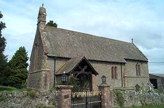
Church of St Mary , Kinnerton
Kinnerton Church is in the Diocese of Hereford, in the community of Old Radnor in the county of Powys. It is located at Ordnance Survey national grid reference SO2442263144.The church is recorded in the CPAT Historic Environment Record as number 16800 and this number should be quoted in all correspondence.
Summary
St Mary's church lies in the middle of Kinnerton a few kilometres to the south of the Lugg Valley and 7km to the west of Presteigne. A chapel of ease with virtually no documented history, the present edifice is a total Victorian rebuild and retains nothing of the original medieval and later chapel, except for one painting.
A
Church was completely rebuilt in last quarter of 19thC. Nothing of the earlier structure survives.
Parts of the following description are quoted from the 1979 publication The Buildings of Wales: Powys by Richard Haslam
History
It seems probable that Kinnerton emerged as a chapel of ease at some point in the Middle Ages.
The earlier church consisted of low building with lancet windows, a bell-turret at west and also a west porch.
It was rebuilt in 1884-5, perhaps by Stephen Williams.
The churchyard was extended in the 1940s.
Architecture
Church consists of nave, narrower chancel, vestry on north side of chancel, south porch attached to south-west corner of nave, and bell turret at west end. The church is aligned slightly south of west, but for descriptive purposes 'ecclesiastical east' is adopted here.
Fabric: small to medium slabs of grey-brown shale weathering to grey, coursed. Dressings including quoins in brick red sandstone. Wholly Victorian.
Roofs: slated, toothed ridge tiles, cross finial on chancel. Bell turret in red sandstone with cross on top. Chimney projects from north side of chancel roof.
Drainage: nothing obvious on north though some possible disturbance outside chancel wall. On south downpipes but no certain drainage trench.
Exterior
Nave. General. Chamfered plinth at base (at height of 0.4m), another at c.3m but restricted to west end. Here too a pair of hollow-chamfered lancets with hoodmoulding and decorated stops. Other sides have more simple single and double lancets.
Chancel. General. East wall has string-course which steps up beneath east window. This is a triple lancet with continuous hoodmoulding but lacks the elaboration of the west window. Double lancet in south wall has quatrefoil light over.
Vestry. General. As chancel but lit by single lights.
Porch. General. Plain walls with a south entrance that has arch-braced tie-beam and cusped struts above.
Interior
Porch. General. Two steps up into porch; flagged floor; roof of scissor trusses. Stone benches against side walls. South door to church has a multifoiled head in red sandstone. One step up into interior.
Nave. General. Tiled floor with carpet over, flush wooden flooring under benches; no heating ducts. Roof of scissor trusses with arch-braced truss as chancel arch resting on 13thC-type imposts. Walls plastered but not window embrasures.
Chancel. General. One step up chancel, two to sanctuary; tiled floor; raised choir stalls. Roof as nave, but ribbed panels as ceiling over altar. Beside the altar, aumbry to north, piscina to south.
Churchyard
Kinnerton churchyard has a quadrilateral shape with the church itself pushed back into the south-east corner. A path bisects the present yard on a north-east/south-west axis and the ground to the north is an extension of c.1943. Possibly south-western part is also an extension: a curving bank (see below) could define an earlier perimeter.
Churchyard occupies a shelf for the ground rises gradually to north and falls to south, and also a gradual fall to east.
It is well-maintained throughout.
A stone wall encloses the area and a datestone of 1951 reveals when northern extension was walled. It is raised throughout from about 1m on west to 1.7m at south-east corner. Even the post-war extension is 1m higher than the road outside.
Monuments: small dense cluster immediately to south of church; less dense to west and north, and new graves in extension to north-west. None earlier than 1840s.
Furniture: none.
Earthworks: low bank on west side of church curves round to merge with internal banking behind stone churchyard wall on south side of church. Possible earlier churchyard line?
Ancillary features: double, ornate, metal gates on south; iron kissing gate on west; metal gates on east to facilitate burial access. Tarmac paths.
Vegetation: some yews, the one to north-east of church of some age. Other trees both deciduous and evergreen species.
Sources consulted
CPAT Field Visit: 21 February 1996
Haslam 1979, 237
Click here to view full project bibliography
Please note that many rural churches are closed to the public at certain times. It is advisable to check when the church will be open before visiting. Information about access, or how to contact parish clergy, can often be obtained from the relevant Diocesan Office which can be found through the Church in Wales website. Further information about Kinnerton Church may also be found on the Hereford Diocese website.
This HTML page has been generated from the Cadw Churches Survey database & CPAT's Regional Historic Environment Record - 17/07/2007 ( 22:02:45 ).
 The CPAT Radnorshire Churches Survey Project was funded by Cadw as part of an all Wales survey of medieval parish churches.
Further information about this and other churches surveyed is available from the Regional Historic Environment Record, Clwyd Powys Archaeological Trust, Curatorial Section, 41 Broad Street, Welshpool, Powys, SY21 7RR tel - (01938) 553670, fax - (01938) 552179, email - chrismartin@cpat.org.uk, website - www.cpat.org.uk.