
|
Back Home |
|
|
Index to Montgomeryshire Churches survey |
Montgomeryshire Churches Survey
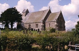
Church of St Michael , Llanfihangel-yng-Ngwynfa
Llanfihangel-yng-Ngwynfa Church is in the Diocese of St Asaph, in the community of Llanfihangel in the county of Powys. It is located at Ordnance Survey national grid reference SJ0803016944.The church is recorded in the CPAT Historic Environment Record as number 16407 and this number should be quoted in all correspondence.
Summary
St Michael's church in the small village of Llanfihangel-yng-Ngwynfa, some 11 miles to the north-west of Welshpool, stands on high ground, within a polygonal churchyard. The present church was built in 1862, and few of the fittings from earlier times have been retained: a bell, the font and some benefaction boards appear to be the sole survivals, other than three inscribed stones of 14thC date set into the walls of the vestry.
Church rebuilt in 1862/3 in Gothic style; some re-use of old masonry on the north side.
Parts of the following description are quoted from the 1979 publication The Buildings of Wales: Powys by Richard Haslam
History
The date of the foundation of Llanfihangel is uncertain, though dedications to Michael are often attributed to the later centuries of the early medieval period.
The church is recorded in the Norwich Taxation of 1254 as 'Capella de Llanvihangel' at a value of 13s 4d and in the Lincoln Taxation of 1291 as 'Ecclia de Lanvyhangel' at ś5.
A new church was built on the site in the 16thC or 17thC and a chancel added in 1723. This building had the chancel wider than the nave, a belfry protruded through the latter and there was a southern porch and a dormer window in the nave roof. A dog-leg staircase led up to the belfry from the west end of the nave. Pews to either side of the central aisle ran up to the sanctuary, and the pulpit and reading desk were against the east wall of the chancel.
In 1862, the old church was demolished, the vicar at the time noting that the walls of the nave were constructed of weatherworn stones while the chancel was of quarried stone. A new church was built in its stead at a cost of ś1081, and consecrated in 1864. A canopied pew with the date of 1577 was removed to Wynnstay at this time.
The building was declared unsafe in 1987 and closed for services. Extensive restoration took place and the church was re-opened in 1990.
St Michael's Well, known to have been sited in the village some 150m from the church, was formerly used for baptisms. Its precise location is now unclear.
Architecture
The present church consists of a nave, a slightly narrower chancel, a south porch and north vestry, both towards the west end of the building, and a bell turret above the west gable. The building is oriented almost exactly west to east.
Fabrics: 'A' is of small to medium linear blocks of local grey and brown shale, (some of it closer to sandstone), with quoins of similar material. Apertures have sandstone dressings. 'B' contains more irregular lumps of shale and includes at least one block of red sandstone. Almost certainly re-used stone from the earlier church.
Roofs: slates with grey, reconstituted clay ridge tiles; metal cross finial to chancel end, stone cross to nave end.
The bell turret rises directly from the gable end; two-tiered with a saddleback roof; small apertures with sandstone dressings.
Drainage: guttering and downspouts (fairly recently renewed) lead to soakaways. Stone chippings, c.0.8m wide, have been placed around all walls of the church, suggesting a surrounding drainage trench.
Exterior
Nave. General. Stone capped plinth at 0.5m around all walls; angle buttresses at corners; paired lancets in north and south walls (and a single lancet to the west of the porch), those on the south, east of the porch, having hoodmoulds with human-head stops. In the west wall a single lancet in a square-headed aperture, and higher up at the apex of the gable a narrow, louvred, shoulder-arched window.
Chancel. General. Lower roof line than nave. Plinth at about 1m above ground level around all walls; angle buttresses at east corners. Single standard lancets with hoodmoulds and stops in north and south walls, and in the east wall, a two-centred window with three plain lancet lights and a hoodmould with head stops.
Porch. General. Side walls are plain, and the south wall has a two-centred entrance, chamfered with pyramid stops, a hoodmould with head stops, and above a datestone with 1863.
Vestry. General. 1923 addition. Datestone in north wall.
Interior
South porch. General. Tiled floor, benches along the sides; six close-set scissor trusses with exposed planked ceiling.
Nave. General. West end is partitioned off and provides access to the bell turret. 19thC tiled floors but carpetted in centre aisle; benches raised on plank flooring. Walls plastered leaving exposed dressings; fenestration set in semi-circular-headed splayed embrasures. Eight arch-braced scissor trusses form five full bays and two half bays, with exposed rafters and purlins; the trusses spring from short wall posts and the wall plates. A narrow two-centred chancel arch in red sandstone on the east, while on the partition panelling at the west end are four Benefaction boards. High up in the west wall behind a truss is a small two-centred window with chamfered dressings.
Chancel. General. Two steps up from the nave, one to the sanctuary, one to the altar. Tiled floor; plastered walls, splayed apertures and a tiled reredos; roof of three bays separated by two scissor trusses with cusped panels above, unlike the plain nave trusses, and springing from stubby wall posts.
Vestry. General. Tiled floor, plastered walls and ceiling above exposed rafters. Incorporated in the walls are three carved medieval stones, unplastered. In 1722 these had been used as a sill and jambstones in the sill of a south window - the inscriptions published by RCAHMW in 1911 are no longer fully decipherable
Churchyard
The original polygonal churchyard was extended on the north-west side in 1914, to create a slightly larger but similarly shaped enclosure, sitting on a low summit from which the ground slopes away in all directions. It is overgrown on the north and east sides, though elsewhere is well maintained.
Boundary: walls on the east, south and south-west sides, largely acting as retaining walls because the ground falls away. Hedge boundary to the north and north-west, a sign of the 1914 extension.
Monuments: graves on all sides; mainly slate slabs of 19thC date, and also several chest tombs. The grave of Ann Griffiths (1776-1805), a famous Welsh Hymn writer, is located on the west side of the entrance path. The red granite pillar that marks the grave stands on a square plinth surrounded by low railings. The earliest gravemarker that was seen was of 1747, but there are a number of much weathered (?18thC) chest tombs.
Furniture: none noted.
Earthworks: the bank of the earlier churchyard is still visible as a scarp up to 1m high on the west and north of the church.
Ancillary features: a pair of 19thC wrought iron gates set in stone pillars form the sole entrance, on the south. A tarmac path leads to the south door of the church.
Vegetation: four pairs of yew trees form an entrance arch over the south path. A single yew is located east of the entrance path on the sloping burial ground.
Sources consulted
CPAT Field Visit 27 October 1995 and 4 March 1998
Crossley and Ridgway 1947, 192
Eisel 1986, 183
Faculty St Asaph 1914 (NLW)
Gresham 1968, 125; 156; 158
Haslam 1979, 131
Jones 1992, 198 (holy wells)
NMR Aberystwyth
Powys SMR
Ridgway 1997, 144
RCAHMW 1911, 93
Thomas 1911, 227
Click here to view full project bibliography
Please note that many rural churches are closed to the public at certain times. It is advisable to check when the church will be open before visiting. Information about access, or how to contact parish clergy, can often be obtained from the relevant Diocesan Office which can be found through the Church in Wales website. Further information about Llanfihangel-yng-Ngwynfa Church may also be found on the St Asaph Diocese website.
This HTML page has been generated from the Cadw Churches Survey database & CPAT's Regional Historic Environment Record - 17/07/2007 ( 22:02:05 ).
 The CPAT Montgomeryshire Churches Survey Project was funded by Cadw as part of an all Wales survey of medieval parish churches.
Further information about this and other churches surveyed is available from the Regional Historic Environment Record, Clwyd Powys Archaeological Trust, Curatorial Section, 41 Broad Street, Welshpool, Powys, SY21 7RR tel - (01938) 553670, fax - (01938) 552179, email - chrismartin@cpat.org.uk, website - www.cpat.org.uk.