
|
Back Home |
|
|
Index to Eastern Conwy Churches survey |
Eastern Conwy Churches Survey
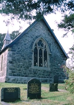
Church of St Winifred , Gwytherin
Gwytherin Church is in the Diocese of St Asaph, in the community of Llangernyw in the county of Conwy. It is located at Ordnance Survey national grid reference SH8767161464. At one time it was dedicated to St James.The church is recorded in the CPAT Historic Environment Record as number 16790 and this number should be quoted in all correspondence.
Summary
St Winifred's church lies at the heart of the small village of Gwytherin in a remote part of Conwy. It has a long history associated with St Winefride, but the present church was built in the later 19thC and, an old chest apart, contains nothing of an earlier date. The churchyard is an irregular shape but is notable for four standing stones in a line, the westernmost of which is an early medieval pillar stone, and some ledgers of the late 17thC/early 18thC.
The church is a totally Victorian structure of 1867-9, though the foundations of the earlier church were used on the north side, and it may have been necessary to resort to earlier material to complete the east gable.
Parts of the following description are quoted from the 1986 publication The Buildings of Wales: Clwyd by Edward Hubbard
History
Traditionally a church was established at Gwytherin in the early medieval period and there is a legend that St Winefride became abbess of a convent here. Archdeacon Thomas reported that this was a clas foundation and that the original church had been founded by St Eleri, but when rebuilt it was re-dedicated to St James. A knoll to the south is the site of a chapel to St Winefride (Penbryn Chapel), and recent research by Hulse suggests that the early medieval 'llan' incorporated this knoll as well.
In the 1254 Taxatioappears 'Ecclesia de Gwytherin et Nanclyn' (Nantglyn), but it appeared separately in 1291 at a value of ś4 1s 8d.
Subsequently the chapel had its own enclosure but the rural dean's report of 1729 indicates that it was once again integrated with the churchyard of Gwytherin. By this time the chapel had become a ruin.
Glynne in 1852 found a simple church with a roof 'of the usual Welsh construction', but boarded over the sanctuary. Some windows had been replaced in recent times but the east window had two trefoiled lights and a little stained glass, and there was a square-headed window with two obtuse-headed lights on the south side. A report of 1858 mentions two lancet lights at the east end, two wooden chests in one of which was 'a portion of the coffin of St Winifred', the octagonal font, and some large yews. The south door appears to have been cyclopean, there was a round-headed priest's door that had been blocked, and a dormer window to light the gallery.
By the 1860s it had become very dilapidated - photograph in Thomas 1911, 313 - and was rebuilt in 1867-9 by Lloyd Williams & Underwood, a copy of its single chamber predecessor, at a cost of ś750. The two medieval sepulchral slabs were uncovered at this time.
The church was rededicated in 1990 after deconsecration in 1982 and eight years of disuse.
Geophysical prospecting in 1995 failed to pinpoint the chapel site in the field to the south of the church.
Architecture
Gwytherin church comprises a nave and chancel as one chamber, a south porch and a north vestry. A small bell turret is set centrally over the nave in line with the porch. The church is oriented due east to west.
Fabrics: 'A' of blocks and slabs of grey shale, small to medium in size and exhibiting some degree of coursing. Quoins of light grey stone that may be limestone. A homogeneous appearance. 'B' is of mixed shale and siltstone with some rounded stone, giving a heterogeneous appearance. Traces of limewash unlike 'A'.
Roof: slates with?terracotta ridge tiles, and a cross finial on the chancel. Reconstituted clay tiles on porch. Bell-turret has slated sides and a timber chamber with louvred openings; above is a spirelet.
Drainage: whole building has a 0.5m wide trench around it.
Exterior
Nave and chancel. General. No external differentiation between nave and chancel. Walls founded on a chamfered plinth of large blocks of?limestone.,
North wall: beneath the plinth in the drainage trench are large lumps of stone which may be part of the earlier structure. Wall in Fabric 'A'. Three windows, one with a single cusped light, the others paired cusped lancet lights, all in pale yellow freestone, though the jambs of the double lights are in a pink sandstone. Vestry at its east end, possibly added at a later date for the cusped heads of its windows appear to have been cut down suggesting re-use.
East wall: lower part in 'A' but upper part of wall from below window springer level in 'B'. Two-centred window has three cusped lights with a trefoil and other subsidiary lights. Above is a stopped hoodmould in buff yellow freestone and over this a relieving arch in shale blocks.
South wall: 'A' throughout, with standard windows, the outer two, single lancets, the inner two of paired lancets.
West wall: 'A' throughout, though less regular blocks in gable. Three cusped, stepped lights.
Porch. General. All in 'A' and in buff yellow freestone. Plain east and west walls. South wall has a two-centred doorway with chamfered dressings terminating in broach stops; hoodmould with cube stops.
Interior
Porch. General. One step up from churchyard. Tiled floor, walls plastered and whitewashed, simple raftered roof. South door of church has high two-centred arch and chamfered dressings with broach stops.
Nave. General. Tiled floor, no vents, benches raised on wooden boarded floors. Walls plastered and whitewashed. Nave and chancel have roof of five bays with arch-braced trusses and raking struts. Splayed Victorian window embrasures throughout. North wall carries a marble mural tablet of 1848/1861 and the south wall an Incorporated Church Building Society panel of 1910 and an undated benefaction board.
Chancel. General. No chancel as such but two steps up to sanctuary (incorporating a sepulchral slab) and one to altar. Tiled floors and walls and roof as nave. Windows as nave. Another sepulchral slab set in north wall.
Churchyard
Gwytherin churchyard is rectilinear, and occupies a spur with the ground dropping to the north and east above the valley of the Cledwen, the church occupying the highest point in the enclosure. On the south side of the church the ground drops down into a natural hollow before rising to another knoll, the site of the former Penbryn chapel. This hollow lies within the churchyard but it is not clear whether this is a later intake - the scarp slope may represent an earlier boundary but could be very largely natural. It is well kept and is still used for burial.
Boundary: fences of no great age delimit the yard on the south-west and south, there is a stone wall on the east and just a stream on the north. Only on the north-west is there a trace of a relict bank in front of the present stone wall.
Monuments: regularly laid out but not dense on the south and west with a few to the east and fewer to the north. There are none in the hollow south of the church. The memorials are in a variable state of preservation - some of the chest tombs have collapsed. The earliest are ledgers to the east of the chancel; one from the 1680s is partly illegible and two others date to 1707.
Furniture: north of the church are four standing stones in a line, two of them first recorded in a visitation of 1710. The westernmost has a Latin inscription commemorating Vinnemaglus, son of Senemaglus, and is dated to the 5thC or early 6thC.
Earthworks: as noted above there is a 1m-high scarp around the south side of the church and its curves slightly as it runs around the east side. This may indicate a former boundary though it could be largely natural. At the east end, too, the church occupies a levelled platform.
Ancillary features: double, wrought iron gates at west entrance with a concrete path to the porch.
Vegetation: four old yews, that to the east of the chancel being the most venerable.
Sources consulted
CPAT Field Visit: 15 October 1996
Deconsecration decree: St Asaph 1982 (NLW)
Glynne 1884, 251
Gresham 1968, 102; 108
Hubbard 1986, 178
Hulse 1994: typescript
Knight, J: typsecript
Quinquennial Review 1993
Ridgway 1997, 92
Thomas 1911, 312
Click here to view full project bibliography
Please note that many rural churches are closed to the public at certain times. It is advisable to check when the church will be open before visiting. Information about access, or how to contact parish clergy, can often be obtained from the relevant Diocesan Office which can be found through the Church in Wales website. Further information about Gwytherin Church may also be found on the St Asaph Diocese website.
This HTML page has been generated from the Cadw Churches Survey database & CPAT's Regional Historic Environment Record - 17/07/2007 ( 22:01:13 ).
 The CPAT Eastern Conwy Churches Survey Project was funded by Cadw as part of an all Wales survey of medieval parish churches.
Further information about this and other churches surveyed is available from the Regional Historic Environment Record, Clwyd Powys Archaeological Trust, Curatorial Section, 7a Church Street, Welshpool, Powys, SY21 7DL tel - (01938) 553670, fax - (01938) 552179, email - chrismartin@cpat.org.uk, website - www.cpat.org.uk.