
|
Back Home |
|
|
Index to Brecknockshire Churches survey |
Brecknockshire Churches Survey
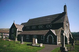
Church of St Cynog , Ystradgynlais
Ystradgynlais Church is in the Diocese of Swansea and Brecon, in the community of Ystradgynlais in the county of Powys. It is located at Ordnance Survey national grid reference SN7872010056.The church is recorded in the CPAT Historic Environment Record as number 16979 and this number should be quoted in all correspondence.
Summary
St Cynog's church is located on the east side of the River Tawe and is now surrounded by modern housing. The present building in Victorian Gothic was constructed in 1861, replacing a reputedly Norman church, which lay 50m to the north and whose position on a raised platform is marked by an obelisk. Only a few monuments and two early medieval stones were preserved during the demolition of the earlier structure. This may have occupied a sub-circular churchyard but the present yard has been enlarged considerably during the last two hundred years.
Church completely built in 1861 on new site.
Parts of the following description are quoted from the 1979 publication The Buildings of Wales: Powys by Richard Haslam
History
The location and dedication of the church suggests an early medieval origin, which may be reinforced by the inscribed stones set in the chancel wall and taken from the old church.
No reference to Ystradgynlais has been found in either Taxatio, but in the Valor Ecclesiasticus it appears as 'Estradguillos' and was worth ś9 10s 7d.
Jones, in 1809, recorded that the church dedication was to St Mary, but he had no doubt that the patron saint was Gwnlen or Gunleus.
The previous church, reputed to be of Norman date, stood on a raised platform some 50m to the north of the present building. It is claimed that its foundations are still visible, though this could not be substantiated in 1995, and the whole area is now covered by graves. Theophilus Jones noted that the old church was 'low, dark and too small for the parish'. It was 63' long and 23' wide and had a gallery built in 1743 placed across the middle of the nave.
The present church was built by Benjamin Ferrey between 1858 when the specification was drawn up and 1861. Haslam points out that it is such an odd building that it might have been largely built by the Reverend Thomas Walters, and indeed Jones (in 1930) recorded that the vicar was his own architect. Stone from the old church was supposed to be re-used, but there is no evidence of this in the external faces of the present building. A north-west tower was planned but never built. Vestry and organ chamber were added in 1933.
Architecture
A large Victorian building consisting of nave and chancel, north and south aisles, north porch at west end of north aisle and a vestry at east end, and an organ chamber at east end of south aisle. Bellcote over west end of nave. The church is oriented south-west/north-east but 'ecclesiastical east' is adopted for this description.
Fabric: consistently of blocks of grey granular sandstone, randomly coursed. All the dressings have been painted white to produce a contrasting pattern.
Interior General. Haslam describes interior as large, bright and ungainly. Stone arcades separating nave from aisles are set on spindly paired iron colonnettes with carved capitals. Clerestory of paired circular trefoiled windows. Scissor truss roofs with big cusped bracing. Wooden block floor with underfloor heating vents. Three steps up from nave to chancel, two steps up to sanctuary.
Churchyard
The churchyard is large and of irregular form, having been enlarged on several occasions during the last two hundred years (cf 1st Edition Ordnance Survey map 1:2500). Contrary to some reports the angular northern part of the present churchyard is unlikely to represent the perimeter of the medieval churchyard - there has certainly been some modification on the northern side in the last one hundred years.
The churchyard is located on the eastern side of River Tawe, set back a very short distance from the edge of the river terrace, which manifests itself by a sudden drop outside the churchyard wall into vicarage garden. There is a slight drop in the slope from north to south, and the site of the old church is on level ground at the highest point in the modern churchyard.
Churchyard is well-kept.
Boundary: is a mortared stone wall with concrete coping. In places a slight build up of soil etc behind wall, but generally the external ground level only a little greater than internal level. Exception is on west where external drop is more than a metre and possibly closer to two metres lower than inner level.
Monuments: most graves are 19thC, and to south of the present church they are tightly packed into churchyard extension. Notable are a number of cast iron memorials, one dating to 1866. North of the present church graves are sparser and some patches of ground are apparently devoid of burials. Between old and new churches a good range of 18thC stones - the earliest seen was of 1735 - but all are lying flat and many are broken off towards base, as a result of deliberate policy of overturning gravestones some years ago.
Furniture: sundial complete with gnomon, the dial inscribed 'Thos Keats' but no date, set on an iron pillar to north-west of present church. Also an obelisk with an inscription occupies the location of chancel of the old church.
Earthworks: a scarped platform, up to 0.7m high, and clearly evident on south, while on the east it fades as it runs northwards; not visible on west. Perhaps about 40m x 40m, and representing the location of the old church and, just conceivably, the earliest churchyard. Also visible to the south and west of the present church is a pre-late 19thC boundary showing as a scarp which has been cut back to allow graves to be inserted.
Ancillary Features: modern stone lychgate with metal gates in north angle of churchyard; further entrances in north-west corner and?in south. Tarmac paths including complete circuit around Victorian church.
Vegetation: several yew trees to north of present church and one to south. Conifers around edge of graveyard extension south of church.
Sources consulted
CPAT Field Visit: 23 November 1995
Dawson 1909, 238
Faculty 1858: NLW/SD/687
Haslam 1979, 387
Hughes 1961
Jones and Bailey 1930, iv, 82 & 90
NMR, Aberystwyth
Click here to view full project bibliography
Please note that many rural churches are closed to the public at certain times. It is advisable to check when the church will be open before visiting. Information about access, or how to contact parish clergy, can often be obtained from the relevant Diocesan Office which can be found through the Church in Wales website. Further information about Ystradgynlais Church may also be found on the Swansea and Brecon Diocese website.
This HTML page has been generated from the Cadw Churches Survey database & CPAT's Regional Historic Environment Record - 17/07/2007 ( 22:01:10 ).
 The CPAT Brecknockshire Churches Survey Project was funded by Cadw as part of an all Wales survey of medieval parish churches.
Further information about this and other churches surveyed is available from the Regional Historic Environment Record, Clwyd Powys Archaeological Trust, Curatorial Section, 7a Church Street, Welshpool, Powys, SY21 7DL tel - (01938) 553670, fax - (01938) 552179, email - chrismartin@cpat.org.uk, website - www.cpat.org.uk.