
|
Back Home |
|
|
Index to Brecknockshire Churches survey |
Brecknockshire Churches Survey
Llandulas Church
Llandulas Church is in the Diocese of Swansea and Brecon, in the community of Llangammarch in the county of Powys. It is located at Ordnance Survey national grid reference SN8797841296.The church is recorded in the CPAT Historic Environment Record as number 16839 and this number should be quoted in all correspondence.
Summary
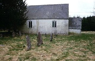
Llandulas church, lacking any known dedication, is a small whitewashed building about 19km south-west of Builth Wells. It is said to have been built in the 18thC and restored in the 19thC, and nothing of its predecessor(s) is known. Apart from some 18thC memorials there are no features of pre-19thC interest internally. The church lies in the southern sector of its polygonal churchyard which may add credence to the view that the present structure was erected on a new site.
A small plain church with wooden windows, probably 18thC.
Parts of the following description are quoted from the 1979 publication The Buildings of Wales: Powys by Richard Haslam
History
It is not known whether there was a medieval or even an early medieval church on or near this spot; its location is suggestive, but there is nothing to support such a contention, and Theophilus Jones at the beginning of the 19thC claimed that the situation of the old church was not known. Dawson's view was that this was solely a mortuary chapel built at the beginning of the 18thC . To her it was known as Ty'r Abat while Jones offered a range of names including 'Tyr Abot, otherwise Newchurch, otherwise Llandulas'.
A plaque within the church records the building of 'Capella nova de Tir Abbat' in 1716. It was supposedly altered in 1871.
Architecture
The church comprises a nave and chancel as a single cell without any external differentiation, and a west porch. It is oriented fractionally north of east.
Fabric: 'A' consists of small and medium slabs and a few blocks of stone, irregularly coursed. But exposed over only a small area of the east wall with the rest of the external wall faces plastered and whitewashed.
Roofs: slate with reconstituted clay ridge tiles; no finials.
Drainage: a drainage trench with a maximum width of 0.5m and of unknown depth around the whole building.
Exterior
Nave and chancel. General. External walls are plastered and whitewashed.
North wall: plain but for two rectangular wooden-framed windows with near segmental heads turned in edge stones; each contains two two-centred headed lights; jambs of selected stone, rather than freestone dressings.
East wall: wall face recently stripped of plaster but painted over with whitewash. Rectangular wooden-framed window with slightly peaked head but otherwise exactly as windows in north wall.
South wall: wall is slightly bowed. Two windows as on north though heads barely curved.
West wall: porch against wall. High up in gable end is a rectangular window with louvre-boards, presumably the equivalent of the bell turret.
Porch. General. Plain walls on north and south. High and acute two-centred archway without chamfers in west face.
Interior
Porch. General. Concrete floor, walls whitewashed; steeply pitched ceiling showing two purlins.
North and south walls: plain.
East wall: wooden door frame with segmental head matching external windows.
West wall: inner arch to main porch doorway turned in brick; a wooden gate with metal grilling covers the whole entry.
Nave. General. One step up from porch. Tiled floor with carpet down the aisle; benches and other furnishings on flush wooden boarding. Walls plastered and whitewashed. The roof of nave and chancel is continuous with eight bays; trusses have braced collars with king and raking struts above. Griffiths of RCAHMW noted that the roof timbers looked old but were in fact no earlier than the 19thC.
North wall: two splayed windows and a disconformity between them which is probably the position of the original north door, now plastered over. An irregularity in the wall face also, where the braced trusses meet the wall - could the wall have been heightened, and if so how early is the lower part of the wall? One graveslab of 1773 against wall.
South wall: two windows; no disconformity compared with north wall.
West wall: wall face is uneven, but nothing of obvious significance.
Chancel. General. One step up into chancel cum sanctuary. Floor tiled. East wall painted yellow but otherwise as nave. Roof is continuation of nave as noted above.
North wall: irregularity at wall post level continues from nave. One mural slab of 1726.
East wall: splayed window. Two large marble mural tablets of 1734 and of the 19thC with two upright graveslabs of 1787 and 1777 below.
South wall: one upright graveslab of 1819.
Churchyard
The church was set within what might be classed as a circular churchyard, though on early editions of the Ordnance Survey map at least it was shown as more polygonal than circular. Now the churchyard has been expanded on the south and east, reaching almost to the river.
Church and churchyard are on flat ground occupying a terrace within 30m of the infant River Dulas. A second, higher terrace supports the village to the west.
Boundary: a wire fence on the south and east, a mortared wall on the north, and only on the north-west is there a hint of a curving bank. There is also some internal banking on the north side.
Monuments: some to the north of the church and a few by the south-east angle, but all sparsely spread. All are 19thC and nothing earlier was recognised.
Furniture: none.
Earthworks: the former churchyard boundary on the south side shows as a scarp bank, up to 0.5m high, and on the east rises to about 1m and incorporates tree stumps and two surviving deciduous trees; this is probably the natural terrace.
Ancillary features: main entrance is via a modern wooden latched gate on the west, with the approach to the church along a grass path. There is also an old metal gate on the north side, now little used, but the main access in the 19thC.
Vegetation: there are two yews of no great age immediately to the north-east of the church, some conifers on the south and west boundaries, and two deciduous trees on the old eastern boundary.
Sources consulted
CPAT Field Visit: 14 May 1996
Dawson 1909, 231
Haslam 1979, 374
Jones and Bailey 1909, ii, 211
NMR Aberystwyth
Click here to view full project bibliography
Please note that many rural churches are closed to the public at certain times. It is advisable to check when the church will be open before visiting. Information about access, or how to contact parish clergy, can often be obtained from the relevant Diocesan Office which can be found through the Church in Wales website. Further information about Llandulas Church may also be found on the Swansea and Brecon Diocese website.
This HTML page has been generated from the Cadw Churches Survey database & CPAT's Regional Historic Environment Record - 17/07/2007 ( 22:00:47 ).
 The CPAT Brecknockshire Churches Survey Project was funded by Cadw as part of an all Wales survey of medieval parish churches.
Further information about this and other churches surveyed is available from the Regional Historic Environment Record, Clwyd Powys Archaeological Trust, Curatorial Section, 7a Church Street, Welshpool, Powys, SY21 7DL tel - (01938) 553670, fax - (01938) 552179, email - chrismartin@cpat.org.uk, website - www.cpat.org.uk.